Greetings Card > Arts > Artists > B > Martin Behaim
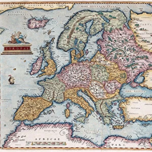
Greetings Card : Globe of 1492, lacking the New World


![]()
Cards from North Wind
Globe of 1492, lacking the New World
Diagram of Martin Behaims globe, made just before Columbus discovered America.
Hand-colored woodcut of a 19th-century illustration
North Wind Picture Archives brings history to life with stock images and hand-colored illustrations
Media ID 5880810
© North Wind Picture Archives
1400s 1492 15th Century Africa Age Of Discovery Asia Cartography Earth Europe Globe India Japan Java Navigation Ocean World Map Behaim Old World Orient
Greetings Card (A5)
"Step back in time with our exquisite selection of Media Storehouse Greeting Cards, featuring the captivating image of Martin Behaim's Globe of 1492 from North Wind Picture Archives. This stunning hand-colored woodcut depicts the world as it was known before the discovery of America. Perfect for history enthusiasts, these cards are a unique and thoughtful way to express your sentiments. Delve into the past and explore the wonders of the unknown with each turn of the page. Order yours today and add a touch of history to your correspondence."
Create your own greetings card. Size when folded is A5 (14.5x21cm or 5.7x8.3 inches)
Greetings Cards suitable for Birthdays, Weddings, Anniversaries, Graduations, Thank You and much more
Estimated Image Size (if not cropped) is 21cm x 14.5cm (8.3" x 5.7")
Estimated Product Size is 21cm x 29cm (8.3" x 11.4")
These are individually made so all sizes are approximate
Artwork printed orientated as per the preview above, with landscape (horizontal) orientation to match the source image.
FEATURES IN THESE COLLECTIONS
> Africa
> Related Images
> Arts
> Artists
> B
> Martin Behaim
> Arts
> Artists
> O
> Oceanic Oceanic
> Asia
> India
> Related Images
> Asia
> Japan
> Related Images
> Asia
> Related Images
> North Wind Picture Archives
> Exploration
> North Wind Picture Archives
> Maps
EDITORS COMMENTS
This print showcases the Globe of 1492, a remarkable artifact that predates Christopher Columbus' discovery of America. The diagram, based on Martin Behaim's globe, provides a fascinating glimpse into the world as it was perceived just before this monumental event in history. Hand-colored and beautifully crafted, this woodcut illustration from the 19th century transports us back to an era when navigation and exploration were at their peak. The absence of the New World on this globe is striking; it reminds us of how limited knowledge about distant lands was during that time. As we study this intricate piece, our eyes are drawn to the vast oceans connecting continents such as Africa, Asia, and Europe. It serves as a reminder of humanity's relentless curiosity to explore uncharted territories. With its rich historical significance and traditional artistic style, this print takes us on a journey through time. It evokes feelings of wonderment and awe for those who have an appreciation for cartography and the Age of Discovery. This image encapsulates not only the artistry involved in creating such maps but also reflects upon our collective heritage as explorers. Whether displayed in homes or educational institutions, this vintage photograph captures both beauty and intellectual curiosity. Its presence invites contemplation about how far we have come since then while honoring the legacy left by pioneers like Martin Behaim.
MADE IN THE UK
Safe Shipping with 30 Day Money Back Guarantee
FREE PERSONALISATION*
We are proud to offer a range of customisation features including Personalised Captions, Color Filters and Picture Zoom Tools
SECURE PAYMENTS
We happily accept a wide range of payment options so you can pay for the things you need in the way that is most convenient for you
* Options may vary by product and licensing agreement. Zoomed Pictures can be adjusted in the Basket.