Greetings Card > Europe > United Kingdom > Scotland > East Lothian > Haddington
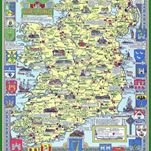
Greetings Card : Old Map of the County of Haddington from the Philips Handy Atlas of 1882


![]()
Cards from MapSeeker
Old Map of the County of Haddington from the Philips Handy Atlas of 1882
PHA016
Welcome to the Mapseeker Image library and enter an historic gateway to one of the largest on-line collections of Historic Maps, Nostalgic Views, Vista's and Panorama's from a World gone by.
Media ID 20348209
County Map County Map Of Scotland Historic Map Old County Map Old Scottish County Map Scottish County Map Haddington Haddingtonshire
Greetings Card Large (A4)
Step back in time with our exquisite selection of greeting cards from Media Storehouse. This particular card features an old map of Haddington County from the Philips Handy Atlas of 1882, sourced from MapSeeker. The intricate details of the antique map are beautifully preserved, making this card a unique and thoughtful gift for history enthusiasts, map collectors, or anyone who appreciates the charm of the past. Send a piece of history with your message, and let the recipient be transported to another era with every greeting.
Create your own large greetings card. Size when folded is A4 (21x30cm or 8.3x11.7 inches)
Greetings Cards suitable for Birthdays, Weddings, Anniversaries, Graduations, Thank You and much more
Estimated Image Size (if not cropped) is 29.7cm x 21cm (11.7" x 8.3")
Estimated Product Size is 29.7cm x 42cm (11.7" x 16.5")
These are individually made so all sizes are approximate
Artwork printed orientated as per the preview above, with landscape (horizontal) orientation to match the source image.
FEATURES IN THESE COLLECTIONS
> Europe
> United Kingdom
> Scotland
> East Lothian
> Haddington
> Europe
> United Kingdom
> Scotland
> Haddingtonshire
> Europe
> United Kingdom
> Scotland
> Lothian
> Haddington
> Europe
> United Kingdom
> Scotland
> Maps
> Maps and Charts
> Early Maps
> Maps and Charts
> Related Images
> MapSeeker
> Maps from the British Isles
> Scotland and Counties PORTFOLIO
EDITORS COMMENTS
This stunning print showcases an exquisite piece of history - the Old Map of the County of Haddington from the Philips Handy Atlas of 1882. Immerse yourself in the rich heritage and charm of Scotland with this Scottish county map. With intricate details and a vintage allure, this old county map takes you on a journey back in time to explore Haddington's past. Discover the historical boundaries, towns, villages, and landmarks that shaped this enchanting region. Every line tells a story, every name evokes nostalgia. As you gaze upon this remarkable historic map, let your imagination wander through centuries gone by. Picture horse-drawn carriages traversing winding roads, bustling marketplaces filled with merchants and locals exchanging goods and stories. Haddingtonshire comes alive before your eyes as you delve into its fascinating history through this authentic representation. From ancient castles to picturesque landscapes, each element on this map invites exploration and sparks curiosity about what once was. Whether you are an avid collector or simply appreciate the beauty of cartography, this print is sure to be a cherished addition to any space. Let it transport you to another era as you admire its intricate details and marvel at how much has changed over time
MADE IN THE UK
Safe Shipping with 30 Day Money Back Guarantee
FREE PERSONALISATION*
We are proud to offer a range of customisation features including Personalised Captions, Color Filters and Picture Zoom Tools
SECURE PAYMENTS
We happily accept a wide range of payment options so you can pay for the things you need in the way that is most convenient for you
* Options may vary by product and licensing agreement. Zoomed Pictures can be adjusted in the Basket.