Greetings Card > Arts > Realistic drawings > Pencil drawings > Black and white artwork
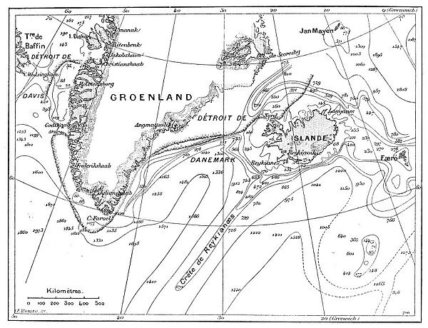
Greetings Card : Antique illustration of Greenland and Iceland bathymetry map
![]()

Cards from Fine Art Storehouse
Antique illustration of Greenland and Iceland bathymetry map
Unleash your creativity and transform your space into a visual masterpiece!
ilbusca
Media ID 13667173
© ilbusca
78279 Atlantic Ocean Atlas Curve Deep Diagram Graph Greenland Iceland Isolated Isolated On White North America North Pole Paintings Pencil Drawing Sketch World Map Bathymetry Classical Style Drawing Art Product Image Created 19th Century Obsolete Painted Image Retro Styled Victorian Style
Greetings Card (A5)
Discover the captivating beauty of the past with our Antique Illustration of Greenland and Iceland Bathymetry Map Greetings Cards from Media Storehouse. This exquisite design, sourced from the Fine Art Storehouse by ilbusca, showcases an intricate and detailed depiction of the underwater terrain of Greenland and Iceland. Each card is a work of art, transporting you back in time to explore the history and wonder of these fascinating lands. Perfect for sending a thoughtful message to a loved one or friend, these vintage-inspired greeting cards are sure to leave a lasting impression. Add a touch of history and charm to your correspondence with our Antique Illustration of Greenland and Iceland Bathymetry Map Greetings Cards.
Create your own greetings card. Size when folded is A5 (14.5x21cm or 5.7x8.3 inches)
Greetings Cards suitable for Birthdays, Weddings, Anniversaries, Graduations, Thank You and much more
Estimated Image Size (if not cropped) is 21cm x 14.5cm (8.3" x 5.7")
Estimated Product Size is 21cm x 29cm (8.3" x 11.4")
These are individually made so all sizes are approximate
Artwork printed orientated as per the preview above, with landscape (horizontal) orientation to match the source image.
FEATURES IN THESE COLLECTIONS
> Fine Art Storehouse
> Map
> Historical Maps
> Arts
> Realistic drawings
> Pencil drawings
> Black and white artwork
EDITORS COMMENTS
This antique illustration takes us back to the 19th century, showcasing a beautifully detailed bathymetry map of Greenland and Iceland. With its retro-styled cartography, this print exudes an air of nostalgia and elegance that transports us to a bygone era. The artist's skillful use of pencil drawing and engraving techniques brings forth intricate details in this painted image. The curves and contours of the world map are meticulously depicted, providing a glimpse into the scientific exploration of the time. This black and white artwork captures the essence of classical Victorian style, evoking a sense of history and culture. Isolated on a white background, this art piece stands out as an exquisite representation of nature's deep mysteries. As we gaze upon it, we can almost feel ourselves being transported to the vast Atlantic Ocean surrounding these Arctic lands. With its obsolete charm, this antique illustration serves as both a historical document and a work of art. It invites us to appreciate not only its aesthetic beauty but also the scientific knowledge it represents. A true gem from ilbusca's collection at Fine Art Storehouse, this print is sure to captivate anyone with an appreciation for vintage maps or those seeking inspiration from our rich past.
MADE IN THE UK
Safe Shipping with 30 Day Money Back Guarantee
FREE PERSONALISATION*
We are proud to offer a range of customisation features including Personalised Captions, Color Filters and Picture Zoom Tools
SECURE PAYMENTS
We happily accept a wide range of payment options so you can pay for the things you need in the way that is most convenient for you
* Options may vary by product and licensing agreement. Zoomed Pictures can be adjusted in the Basket.


