Greetings Card > Arts > Realistic drawings > Pencil drawings > Black and white artwork
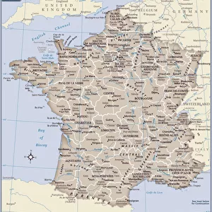
Greetings Card : Antique France Map


Resolution may be poor at this size (82 DPI)
![]()
Cards from Fine Art Storehouse
Antique France Map
France Map, - Antique style. Includes mountains and water bodies. High detail - vector illustration
Unleash your creativity and transform your space into a visual masterpiece!
Media ID 13666481
Cartographer Computer Graphic Computer Graphics Frame Geographical Border Globe Globe Navigational Equipment Intricacy Land National Pencil Drawing Picture Frame Plan Planet Space Sketch Topography Vector Drawing Art Product Painted Image White Color
Greetings Card Large (A4)
Add a touch of old-world charm to your correspondence with our Antique France Map Greetings Cards from Media Storehouse. Featuring intricately detailed vector illustrations, these cards transport you back in time with their fine art representation of France's historic geography. The antique style map includes mountains, water bodies, and other topographical features, making each card a unique work of art. Perfect for birthdays, anniversaries, or just to brighten someone's day, these cards are sure to impress with their high-quality print and elegant design.
Create your own large greetings card. Size when folded is A4 (21x30cm or 8.3x11.7 inches)
Greetings Cards suitable for Birthdays, Weddings, Anniversaries, Graduations, Thank You and much more
Estimated Image Size (if not cropped) is 29.7cm x 21cm (11.7" x 8.3")
Estimated Product Size is 29.7cm x 42cm (11.7" x 16.5")
These are individually made so all sizes are approximate
Artwork printed orientated as per the preview above, with landscape (horizontal) orientation to match the source image.
FEATURES IN THESE COLLECTIONS
> Fine Art Storehouse
> Map
> Historical Maps
> Arts
> Realistic drawings
> Pencil drawings
> Black and white artwork
EDITORS COMMENTS
This print showcases an Antique France Map, exuding a timeless charm with its intricate details and old-world artistry. The black and white computer graphic illustration is meticulously crafted in high detail, depicting the picturesque landscapes of France. From majestic mountains to meandering rivers and serene water bodies, every element is thoughtfully captured. The map's design reflects the expertise of a skilled cartographer, resembling a beautifully painted image with hints of ink and pencil drawing techniques. Encased within an elegant frame, this piece evokes a sense of nostalgia for globe navigational equipment from bygone eras. Transporting us back in time, this antique map unveils the rich history and topography of France. It reveals ancient national borders while highlighting physical geographical features such as lakes, forests, and mountain ranges. Its vintage aesthetic adds character to any space it graces. Perfect for art enthusiasts or those with a passion for travel and exploration, this unique artwork combines elements of both art and craft. Whether displayed in homes or offices alike, this stunning print serves as a testament to the beauty found in maps as well as the artistic skill required to create them.
MADE IN THE UK
Safe Shipping with 30 Day Money Back Guarantee
FREE PERSONALISATION*
We are proud to offer a range of customisation features including Personalised Captions, Color Filters and Picture Zoom Tools
SECURE PAYMENTS
We happily accept a wide range of payment options so you can pay for the things you need in the way that is most convenient for you
* Options may vary by product and licensing agreement. Zoomed Pictures can be adjusted in the Basket.