Greetings Card > Europe > France > Maps
Greetings Card : Map of France, Gallia Antique, from The Atlas of Ancient Geography, by Samuel Butler


![]()
Cards from Fine Art Finder
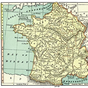
Map of France, Gallia Antique, from The Atlas of Ancient Geography, by Samuel Butler
KW288092 Map of France, Gallia Antique, from The Atlas of Ancient Geography, by Samuel Butler, published in London, c.1829 (colour litho) by English School, (19th century); Private Collection; Ken Welsh; English, out of copyright
Media ID 12791701
© www.bridgemanimages.com
Greetings Card (A5)
Step back in time with our exquisite collection of ancient geography greeting cards from Media Storehouse. This particular design features a captivating Map of France, known as Gallia Antique, taken from The Atlas of Ancient Geography by Samuel Butler. Published in London around 1829, this beautifully detailed, color lithograph image transports you to a bygone era. Perfect for history enthusiasts or anyone looking for a unique and thoughtful greeting card, these cards come in various designs and are blank inside for your personal message. Bring history to life with Media Storehouse's ancient geography greeting cards.
Create your own greetings card. Size when folded is A5 (14.5x21cm or 5.7x8.3 inches)
Greetings Cards suitable for Birthdays, Weddings, Anniversaries, Graduations, Thank You and much more
Estimated Image Size (if not cropped) is 21cm x 14.5cm (8.3" x 5.7")
Estimated Product Size is 21cm x 29cm (8.3" x 11.4")
These are individually made so all sizes are approximate
Artwork printed orientated as per the preview above, with landscape (horizontal) orientation to match the source image.
FEATURES IN THESE COLLECTIONS
> Fine Art Finder
> Schools
> English School
> Europe
> Related Images
> Europe
> United Kingdom
> England
> London
> Related Images
> Maps and Charts
> Early Maps
> Maps and Charts
> Related Images
EDITORS COMMENTS
This print showcases a stunning map of France, specifically Gallia Antique, from The Atlas of Ancient Geography by Samuel Butler. Published in London around 1829, this color lithograph offers a glimpse into the rich history and intricate cartography of ancient Gaul. The map itself is a testament to the meticulous craftsmanship and attention to detail that characterized 19th-century English cartographers. It beautifully captures the various regions and Latin names associated with ancient Gaul, providing an invaluable resource for those interested in European geography or studying the region's past. With its vibrant colors and intricate markings, this piece transports viewers back in time, allowing them to explore the vast expanse of what is now modern-day France through an entirely different lens. From Aquitania to Belgica and beyond, each region comes alive on this map as it whispers stories of ancient civilizations and cultures that once thrived within these borders. As we gaze upon this remarkable image from our private collection, we are reminded not only of the historical significance but also of the enduring beauty found within maps themselves. They serve as gateways to exploration - both physical and intellectual - inviting us to embark on journeys across time and space. So join us as we delve into the depths of ancient Gaul through this mesmerizing Map of France from The Atlas of Ancient Geography by Samuel Butler.
MADE IN THE UK
Safe Shipping with 30 Day Money Back Guarantee
FREE PERSONALISATION*
We are proud to offer a range of customisation features including Personalised Captions, Color Filters and Picture Zoom Tools
SECURE PAYMENTS
We happily accept a wide range of payment options so you can pay for the things you need in the way that is most convenient for you
* Options may vary by product and licensing agreement. Zoomed Pictures can be adjusted in the Basket.