Framed Print > Europe > France > Maps
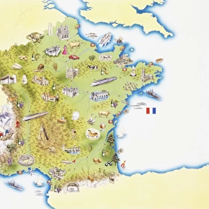
Framed Print : Map of France, Gallia Antique, from The Atlas of Ancient Geography, by Samuel Butler


![]()
Framed Photos from Fine Art Finder
Map of France, Gallia Antique, from The Atlas of Ancient Geography, by Samuel Butler
KW288092 Map of France, Gallia Antique, from The Atlas of Ancient Geography, by Samuel Butler, published in London, c.1829 (colour litho) by English School, (19th century); Private Collection; Ken Welsh; English, out of copyright
Media ID 12791701
© www.bridgemanimages.com
14"x12" (38x32cm) Modern Frame
Discover the rich history of France with our stunning Framed Prints from Media Storehouse. Featuring the captivating Map of France, Gallia Antique, taken from Samuel Butler's Atlas of Ancient Geography, published in London around 1829. This exquisite color lithograph by the English School showcases an ancient perspective of France, making it a unique and intriguing addition to any home or office. Transport yourself back in time and immerse yourself in the history and culture of France with this beautiful and authentic piece of art.
Wood effect frame, card mounted, 10x8 archival quality photo print. Overall outside dimensions 14x12 inches (38x32cm). Environmentally and ozone friendly, 40mm wide x 15mm Polycore® moulding has the look of real wood, is durable and light and easy to hang. Biodegradable and made with non-chlorinated gases (no toxic fumes) it is efficient; producing 100 tons of polystyrene can save 300 tons of trees! Prints are glazed with lightweight, shatterproof, optical clarity acrylic (providing the same general protection from the environment as glass). The back is stapled hardboard with a sawtooth hanger attached. Note: To minimise original artwork cropping, for optimum layout, and to ensure print is secure, the visible print may be marginally smaller
Contemporary Framed and Mounted Prints - Professionally Made and Ready to Hang
Estimated Image Size (if not cropped) is 24.4cm x 19cm (9.6" x 7.5")
Estimated Product Size is 37.6cm x 32.5cm (14.8" x 12.8")
These are individually made so all sizes are approximate
Artwork printed orientated as per the preview above, with landscape (horizontal) orientation to match the source image.
FEATURES IN THESE COLLECTIONS
> Fine Art Finder
> Schools
> English School
> Europe
> Related Images
> Europe
> United Kingdom
> England
> London
> Related Images
> Maps and Charts
> Early Maps
> Maps and Charts
> Related Images
EDITORS COMMENTS
This print showcases a stunning map of France, specifically Gallia Antique, from The Atlas of Ancient Geography by Samuel Butler. Published in London around 1829, this color lithograph offers a glimpse into the rich history and intricate cartography of ancient Gaul. The map itself is a testament to the meticulous craftsmanship and attention to detail that characterized 19th-century English cartographers. It beautifully captures the various regions and Latin names associated with ancient Gaul, providing an invaluable resource for those interested in European geography or studying the region's past. With its vibrant colors and intricate markings, this piece transports viewers back in time, allowing them to explore the vast expanse of what is now modern-day France through an entirely different lens. From Aquitania to Belgica and beyond, each region comes alive on this map as it whispers stories of ancient civilizations and cultures that once thrived within these borders. As we gaze upon this remarkable image from our private collection, we are reminded not only of the historical significance but also of the enduring beauty found within maps themselves. They serve as gateways to exploration - both physical and intellectual - inviting us to embark on journeys across time and space. So join us as we delve into the depths of ancient Gaul through this mesmerizing Map of France from The Atlas of Ancient Geography by Samuel Butler.
MADE IN THE UK
Safe Shipping with 30 Day Money Back Guarantee
FREE PERSONALISATION*
We are proud to offer a range of customisation features including Personalised Captions, Color Filters and Picture Zoom Tools
SECURE PAYMENTS
We happily accept a wide range of payment options so you can pay for the things you need in the way that is most convenient for you
* Options may vary by product and licensing agreement. Zoomed Pictures can be adjusted in the Basket.