Glass Place Mat > Arts > Artists > L > George Landseer
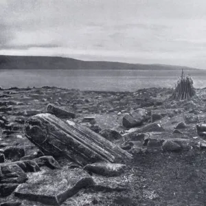
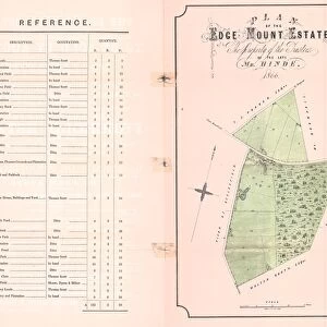
Glass Place Mat : Plan of land along the River Rivelin, Sheffield, 1784


![]()
Home Decor from Sheffield City Archives
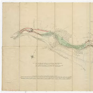
Plan of land along the River Rivelin, Sheffield, 1784
Full title: A plan of the Holme Wheels, and of the lands of the Earl of Surrey held with them by George Spooner and William Hellifield.
Scale 2 chains : 1 inch [40 inches : 1 mile]
Surveyor: William Fairbank II.
Spooner Wheel and dam clearly shown as well as land along the banks of the River Rivelin.
Numerical list with descriptions and acreages.
From an original at Sheffield Libraries: arc03007
Sheffield City Archives and Local Studies Library has an unrivalled collection of images of Sheffield, England
Media ID 19225931
© Sheffield City Council - All Rights Reserved
Bradfield Sheffield Waterwheels Yorkshire
Glass Place Mat (Set of 4)
Set of 4 Glass Place Mats. Stylish and elegant polished safety glass, toughened and heat resistant (275x225mm, 7mm thick). Matching Coasters also available.
Set of 4 Glass Place Mats. Elegant polished safety glass and heat resistant. Matching Coasters may also be available
Estimated Image Size (if not cropped) is 19.7cm x 25.4cm (7.8" x 10")
Estimated Product Size is 22.5cm x 27.5cm (8.9" x 10.8")
These are individually made so all sizes are approximate
FEATURES IN THESE COLLECTIONS
> Arts
> Artists
> L
> George Landseer
> Europe
> France
> Canton
> Landes
> Europe
> United Kingdom
> England
> Surrey
> Related Images
> Europe
> United Kingdom
> England
> Yorkshire
> Holme
> Europe
> United Kingdom
> England
> Yorkshire
> Related Images
> Europe
> United Kingdom
> England
> Yorkshire
> Sheffield
> Europe
> United Kingdom
> England
> Yorkshire
> Well
> Sheffield City Archives
> Maps and Plans
> Maps of Bradfield
EDITORS COMMENTS
This print from Sheffield City Archives takes us back to the year 1784, offering a glimpse into the rich history of land along the River Rivelin in Sheffield. The full title of this remarkable piece is "A plan of the Holme Wheels, and of the lands of the Earl of Surrey held with them by George Spooner and William Hellifield". Surveyed by William Fairbank II, it showcases intricate details such as Spooner Wheel and dam, while also highlighting the beautiful expanse of land that stretches along the riverbanks. The scale used for this plan is truly impressive - 2 chains to 1 inch or 40 inches to 1 mile. This meticulous attention to detail allows viewers to immerse themselves in every aspect captured within this image. Additionally, a numerical list accompanies this print, providing descriptions and acreages for each specific area depicted. Preserved at Sheffield Libraries under reference arc03007, this original piece holds immense historical significance for Yorkshire's Bradfield region. It offers an invaluable window into how these lands were utilized during that era. As we admire this photograph print today, let us appreciate its beauty and acknowledge its importance in documenting our past. It serves as a reminder not only of our connection to nature but also how human ingenuity has shaped landscapes throughout time.
MADE IN THE UK
Safe Shipping with 30 Day Money Back Guarantee
FREE PERSONALISATION*
We are proud to offer a range of customisation features including Personalised Captions, Color Filters and Picture Zoom Tools
SECURE PAYMENTS
We happily accept a wide range of payment options so you can pay for the things you need in the way that is most convenient for you
* Options may vary by product and licensing agreement. Zoomed Pictures can be adjusted in the Basket.


![Maps of Several Parcels of Land proposed to be exchanged, Bradfield, [c. 1750 - 1760]](/sq/716/maps-parcels-land-proposed-exchanged-bradfield-19192402.jpg.webp)
![A map of Wm. Carrs Farm at Stanington [Stannington], 1747](/sq/716/map-wm-carrs-farm-stanington-stannington-1747-19192400.jpg.webp)


![A survey of a parcel of Land called Platts... [Platts Farm, Ughill], 1728](/sq/716/survey-parcel-land-called-platts-19225923.jpg.webp)