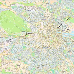
Glass Place Mat > Europe > United Kingdom > England > Yorkshire > Sheffield
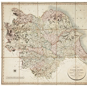
Glass Place Mat : Map of the West Riding of Yorkshire, divided into Wapentakes and Boroughs, and shewing all its Railways, Roads, Rivers, Canals, 1838


![]()
Home Decor from Sheffield City Archives
Map of the West Riding of Yorkshire, divided into Wapentakes and Boroughs, and shewing all its Railways, Roads, Rivers, Canals, 1838
By J H Franks for William Whites Directory of the West Riding.Scale 15 miles : 2.7 inches.Original at Local Studies Library: E3M
Sheffield City Archives and Local Studies Library has an unrivalled collection of images of Sheffield, England
Media ID 14047411
© Sheffield City Council
Canals Maps Rail Rivers Transport Yorkshire
Glass Place Mat (Set of 4)
Set of 4 Glass Place Mats. Stylish and elegant polished safety glass, toughened and heat resistant (275x225mm, 7mm thick). Matching Coasters also available.
Set of 4 Glass Place Mats. Elegant polished safety glass and heat resistant. Matching Coasters may also be available
Estimated Image Size (if not cropped) is 25.4cm x 20.2cm (10" x 8")
Estimated Product Size is 27.5cm x 22.5cm (10.8" x 8.9")
These are individually made so all sizes are approximate
FEATURES IN THESE COLLECTIONS
> Europe
> United Kingdom
> England
> West Yorkshire
> Related Images
> Europe
> United Kingdom
> England
> Yorkshire
> Related Images
> Europe
> United Kingdom
> England
> Yorkshire
> Sheffield
> Maps and Charts
> Related Images
> Popular Themes
> Railway Posters
> Sheffield City Archives
> Maps and Plans
EDITORS COMMENTS
This print showcases a historical treasure, the "Map of the West Riding of Yorkshire, divided into Wapentakes and Boroughs". Created in 1838 by J H Franks for William Whites Directory of the West Riding, this map offers an intricate depiction of the region's geography and transportation networks. With a scale of 15 miles to 2.7 inches, it provides a detailed overview that captures both the grandeur and complexity of Yorkshire. The map not only highlights major landmarks such as railways, roads, rivers, canals but also emphasizes their interconnectedness within this vast landscape. It serves as a testament to the importance placed on efficient transport systems during that era. The inclusion of canals underscores their significance in facilitating trade and commerce across various towns and villages. Preserved at Sheffield City Archives' Local Studies Library under reference E3M, this original piece is undoubtedly invaluable for researchers delving into Yorkshire's rich history. Its meticulous craftsmanship reflects both artistic skill and cartographic precision. As we gaze upon this remarkable image today, we are transported back in time to an era when rail travel was emerging as a transformative force while waterways remained vital arteries connecting communities. This photograph reminds us how our ancestors navigated these lands before modern advancements reshaped transportation forevermore.
MADE IN THE UK
Safe Shipping with 30 Day Money Back Guarantee
FREE PERSONALISATION*
We are proud to offer a range of customisation features including Personalised Captions, Color Filters and Picture Zoom Tools
SECURE PAYMENTS
We happily accept a wide range of payment options so you can pay for the things you need in the way that is most convenient for you
* Options may vary by product and licensing agreement. Zoomed Pictures can be adjusted in the Basket.