Glass Place Mat > Maps and Charts > Related Images
Glass Place Mat : Map of the Rivelin Valley Estate, 1934


![]()
Home Decor from Sheffield City Archives
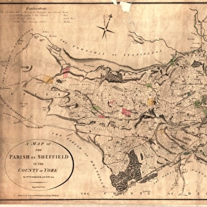
Map of the Rivelin Valley Estate, 1934
Taken from a Report of Special Conference regarding the Development of the Rivelin Valley, Sheffield City Council, Sep 1934.Rivelin Mill, Rivelin Valley Road, Rivelin Hotel, St Michaels RC Cemetery, The Hagg, Roscoe Wheel, Hollins Bridge Mill, Holly Bush Inn, Walkley Bank Tilt, Walkley Bank Plantation, Mousehole Forge, Holme Head Wheel.E Partington, Estates Surveyor.Original at Sheffield Local Studies Library: MP 117 M
Sheffield City Archives and Local Studies Library has an unrivalled collection of images of Sheffield, England
Media ID 14088520
© Sheffield City Council
Bank Bridge Broadsheets Cemetery Corn Farm Forge Holme Hotel Hotels Houses Mill Mills Power Public Rivelin Road Tilt Valley Walkley Water Wheel Hagg Hollins Holly Michaels Mousehole Roscoe
Glass Place Mat (Set of 4)
Set of 4 Glass Place Mats. Stylish and elegant polished safety glass, toughened and heat resistant (275x225mm, 7mm thick). Matching Coasters also available.
Set of 4 Glass Place Mats. Elegant polished safety glass and heat resistant. Matching Coasters may also be available
Estimated Image Size (if not cropped) is 25.4cm x 8.2cm (10" x 3.2")
Estimated Product Size is 27.5cm x 22.5cm (10.8" x 8.9")
These are individually made so all sizes are approximate
FEATURES IN THESE COLLECTIONS
> Maps and Charts
> Related Images
> Sheffield City Archives
> Maps and Plans
> Maps of Sheffield
> Sheffield City Archives
> Maps and Plans
EDITORS COMMENTS
This print showcases the detailed "Map of the Rivelin Valley Estate, 1934" taken from a report of a special conference regarding its development. The map, preserved at Sheffield Local Studies Library, offers an intriguing glimpse into the past and provides valuable insights into the historical landscape of Sheffield City Council in September 1934. The map highlights various landmarks and significant locations within the estate, including Rivelin Mill, Rivelin Valley Road, Rivelin Hotel, St Michaels RC Cemetery, The Hagg, Roscoe Wheel, Hollins Bridge Mill, Holly Bush Inn, Walkley Bank Tilt, Walkley Bank Plantation Mousehole Forge and Holme Head Wheel. These names evoke a sense of nostalgia as they represent key elements that shaped life in this vibrant valley during that era. As we delve deeper into this remarkable piece of history captured by E Partington (Estates Surveyor), we can't help but imagine how these places once thrived with activity. From water mills harnessing power to corn mills grinding away tirelessly to produce sustenance for local communities - each location on this map tells a unique story. While gazing upon this print transports us back in time to witness the charm and beauty of yesteryears' rural landscapes dotted with public houses and hotels like Holly Bush Inn or St Michaels RC Cemetery nestled amidst nature's embrace. It serves as a reminder of our rich heritage and encourages us to appreciate the efforts made by Sheffield City Archives in preserving such invaluable
MADE IN THE UK
Safe Shipping with 30 Day Money Back Guarantee
FREE PERSONALISATION*
We are proud to offer a range of customisation features including Personalised Captions, Color Filters and Picture Zoom Tools
SECURE PAYMENTS
We happily accept a wide range of payment options so you can pay for the things you need in the way that is most convenient for you
* Options may vary by product and licensing agreement. Zoomed Pictures can be adjusted in the Basket.