
Walkley Collection
"Unveiling the Historical Tapestry of Walkley: Tracing its Roots through Maps and Architectural Marvels" Step into the past with a captivating journey through Walkley


All Professionally Made to Order for Quick Shipping
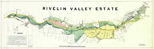
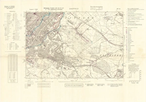
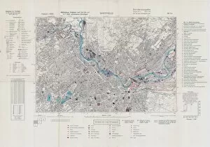
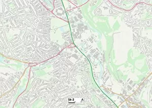
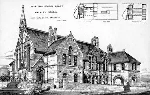
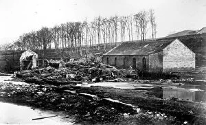
"Unveiling the Historical Tapestry of Walkley: Tracing its Roots through Maps and Architectural Marvels" Step into the past with a captivating journey through Walkley, as we explore its rich history woven together by intriguing maps and architectural wonders. Delving back to 1934, we discover the Map of the Rivelin Valley Estate, offering a glimpse into the area's early development. Fast forward to wartime Sheffield in 1940, where an Ordnance Survey map marked with bombing targets reveals the city's resilience amidst adversity. Transporting us further back in time is a fascinating plan from 1929 showcasing lands at Neepsend by The Sheffield Gas Company. This blueprint offers insights into industrial growth and urban expansion during that era. Venturing even deeper into history, we stumble upon a remarkable map from 1790 depicting Crookes' involvement in both Ecclesall and Nether Hallam. It paints a vivid picture of how this neighborhood evolved over centuries. Architectural enthusiasts will be captivated by Walkley School's Greaves Street design dating back to 1874. Its intricate details reflect educational aspirations embedded within Victorian society. The Cromwell Street area comes alive on an Ordnance Survey Map from 1889 (Yorkshire sheet No. 294. 7. 2), revealing how Walkley transformed throughout the late nineteenth century. Not forgetting nature's impact on this community, remnants of Limbrick Wheels along River Loxley serve as poignant reminders of Sheffield Flood's devastating consequences in 1864 (w00439). These wheels were once part of H. Johnson and S. J. Barkers - makers of crinoline wires - symbolizing resilience amid tragedy (w00427) (w00426). As you navigate through these historical gems like pieces of an intricate puzzle, uncovering layers upon layers that shaped Walkley's identity becomes truly mesmerizing.