Glass Place Mat > Arts > Artists > M > Sebastian Munster
Glass Place Mat : Map of Palestine, 1588


![]()
Home Decor from Science Photo Library
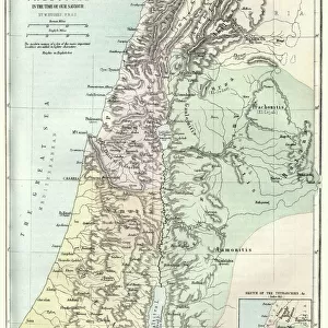
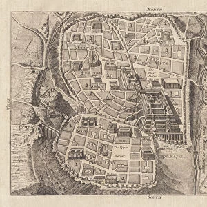
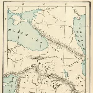
Map of Palestine, 1588
16th century map of Palestine. North is towards upper right. Published in 1588, this German map shows the geography of Palestine, centred on the area that later become the state of Israel. The inscriptions are in German, and the place names are in Latin. These include ancient names like Petra, Coele Syria and Judea. The Dead Sea is at lower centre, and the Mediterranean coast is at left. Numerous towns and villages are shown on the map. The map is by the German cartographer Sebastian Munster (1489-1552), and was published in Basel in a posthumous edition of his Cosmographia, the earliest German atlas
Science Photo Library features Science and Medical images including photos and illustrations
Media ID 1699831
© LIBRARY OF CONGRESS, GEOGRAPHY AND MAP DIVISION/SCIENCE PHOTO LIBRARY
1500s 1588 16th Century Arab Cartography Dead Sea German Israel Jewish Judea Medieval Middle Ages Middle East Palestine Cosmographia Petra Sebastian Munster
Glass Place Mat (Set of 4)
Set of 4 Glass Place Mats. Stylish and elegant polished safety glass, toughened and heat resistant (275x225mm, 7mm thick). Matching Coasters also available.
Set of 4 Glass Place Mats. Elegant polished safety glass and heat resistant. Matching Coasters may also be available
Estimated Image Size (if not cropped) is 25.4cm x 21.9cm (10" x 8.6")
Estimated Product Size is 27.5cm x 22.5cm (10.8" x 8.9")
These are individually made so all sizes are approximate
FEATURES IN THESE COLLECTIONS
> Arts
> Art Movements
> Medieval Art
> Arts
> Artists
> M
> Sebastian Munster
> Arts
> Artists
> S
> Syrian Syrian
> Asia
> Israel
> Related Images
> Asia
> Palestine
> Related Images
> Asia
> Syria
> Related Images
> Science Photo Library
> History
EDITORS COMMENTS
This 16th-century map of Palestine, printed in 1588, offers a fascinating glimpse into the geography and history of the region. Created by renowned German cartographer Sebastian Munster, this map showcases the area that would later become the state of Israel. With its north oriented towards the upper right corner, it presents an array of ancient names like Petra, Coele Syria, and Judea. The inscriptions on this print are in German while the place names are written in Latin. The Dead Sea takes center stage at the lower part of the map, while to its left lies the picturesque Mediterranean coast. This meticulously detailed artwork also highlights numerous towns and villages scattered across Palestine. Published posthumously as part of Munster's Cosmographia atlas in Basel, Switzerland, this historic piece provides invaluable insights into medieval cartography during a time when accurate maps were scarce. It serves as a testament to Munster's expertise and dedication to his craft. As we explore this remarkable snapshot from centuries past, we can appreciate both its artistic beauty and historical significance. From its depiction of ancient landmarks to its portrayal of regional boundaries long before modern political divisions emerged – this print is not only a treasure for geographers but also for those intrigued by Middle Eastern history and culture.
MADE IN THE UK
Safe Shipping with 30 Day Money Back Guarantee
FREE PERSONALISATION*
We are proud to offer a range of customisation features including Personalised Captions, Color Filters and Picture Zoom Tools
SECURE PAYMENTS
We happily accept a wide range of payment options so you can pay for the things you need in the way that is most convenient for you
* Options may vary by product and licensing agreement. Zoomed Pictures can be adjusted in the Basket.