Glass Place Mat > Fine Art Finder > Artists > Grazioso Benincasa
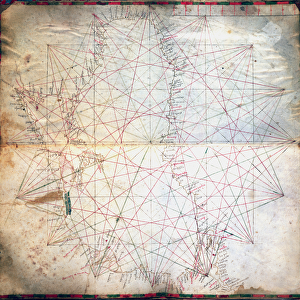
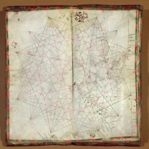
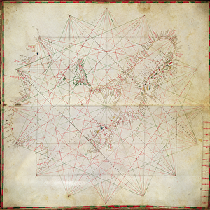
Glass Place Mat : Map of the Eastern Mediterranean (ink on parchment)
")
")


![]()
Home Decor from Fine Art Finder
Map of the Eastern Mediterranean (ink on parchment)
XCF307300 Map of the Eastern Mediterranean (ink on parchment) by Benincasa, Grazioso (fl.1468); Private Collection; Italian, out of copyright
Media ID 12841879
© www.bridgemanart.com
Atlas Chart Cyprus Geographic Greek Islands Mapping Nile Delta
Glass Place Mat (Set of 4)
Set of 4 Glass Place Mats. Stylish and elegant polished safety glass, toughened and heat resistant (275x225mm, 7mm thick). Matching Coasters also available.
Set of 4 Glass Place Mats. Elegant polished safety glass and heat resistant. Matching Coasters may also be available
Estimated Image Size (if not cropped) is 22.5cm x 25.4cm (8.9" x 10")
Estimated Product Size is 22.5cm x 27.5cm (8.9" x 10.8")
These are individually made so all sizes are approximate
FEATURES IN THESE COLLECTIONS
> Fine Art Finder
> Artists
> Grazioso Benincasa
> Fine Art Finder
> Maps (celestial & Terrestrial)
EDITORS COMMENTS
This print showcases a remarkable piece of cartography, the "Map of the Eastern Mediterranean" by Grazioso Benincasa. Created in 1468, this ink on parchment masterpiece is an exquisite example of Renaissance mapping. The intricate details and craftsmanship evident in this artwork transport us back to a time when exploration was at its peak. The map encompasses vast territories, from Greece and its enchanting islands to the Nile Delta in Egypt, as well as Cyprus and other significant locations across Africa, Europe, and the Middle East. As we gaze upon this historical artifact, we are reminded of the importance of geography in shaping our understanding of the world. Each line carefully drawn represents not only coastlines but also connections between cultures and civilizations. The delicate strokes bring life to each island dotting the sea while accurately depicting landmasses with precision. This map serves as both an atlas for sailors navigating treacherous waters and a testament to human curiosity about distant lands. Preserved within a private collection today, this work offers us a glimpse into ancient times when explorers embarked on daring voyages that expanded our knowledge beyond imagination. Through this photograph print from Fine Art Finder's collection by www. bridgemanart. com, we can appreciate Benincasa's artistry while marveling at how his creation continues to inspire awe centuries later.
MADE IN THE UK
Safe Shipping with 30 Day Money Back Guarantee
FREE PERSONALISATION*
We are proud to offer a range of customisation features including Personalised Captions, Color Filters and Picture Zoom Tools
SECURE PAYMENTS
We happily accept a wide range of payment options so you can pay for the things you need in the way that is most convenient for you
* Options may vary by product and licensing agreement. Zoomed Pictures can be adjusted in the Basket.