Glass Frame > Science > Space Exploration > Planets > Venus
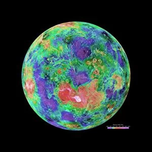
Glass Frame : Topographic map of Venusian north polar region


![]()
Mounted Prints from Science Photo Library
Topographic map of Venusian north polar region
Colour-coded topographic map of the region surrounding Venus north pole. The view is centred on the pole and extends down to a latitude of 20 degrees north. Yellow areas represent high ground & orange areas low ground. The yellow region just below centre is Ishtar Terra and contains Lakshmi Planum (smooth area at left) and the Maxwell Montes (rough terrain at right), the highest mountains on Venus. The rope-like ridges at upper left are thought to be tectonic in origin. The map was compiled using data from the Soviet Venera 15 & 16 spacecraft, the American Pioneer Venus spacecraft and the Arecibo radio telescope in Puerto Rico
Science Photo Library features Science and Medical images including photos and illustrations
Media ID 6426303
© USGS/NASA/SCIENCE PHOTO LIBRARY
Circle Circles Cosmology Planetary Round Shape Rounded Circular Venus
8"x6" Glass Mount
Wall mounted or free-standing, these black edged glass frames feature a smooth chamfered edge and a stylish black border (on back face of the glass). Manufactured from 4mm thick glass, Glass Mounts are a durable, professional way of displaying and protecting your prints. Your 8x6 print is slotted into the back of the frame so can easily be changed if needed.
Tempered Glass Mounts are ideal for wall display, plus the smaller sizes can also be used free-standing via an integral stand
Estimated Image Size (if not cropped) is 15.2cm x 20.3cm (6" x 8")
Estimated Product Size is 17.7cm x 22.8cm (7" x 9")
These are individually made so all sizes are approximate
Artwork printed orientated as per the preview above, with portrait (vertical) orientation to match the source image.
FEATURES IN THESE COLLECTIONS
> Maps and Charts
> Related Images
> North America
> Puerto Rico
> Maps
> North America
> Puerto Rico
> Related Images
> North America
> Related Images
> Science
> Space Exploration
> Pioneer
> Science
> Space Exploration
> Planets
> Venus
> Science
> Space Exploration
> Related Images
> Science
> Space Exploration
> Telescopes Radio
EDITORS COMMENTS
This print showcases a vivid and detailed topographic map of the Venusian north polar region. The image presents a mesmerizing colour-coded representation of the area surrounding Venus' north pole, with its focal point centered on the pole itself and extending down to a latitude of 20 degrees north. The vibrant yellow hues indicate high ground, while orange areas represent low-lying terrain. One cannot help but be drawn to the prominent yellow region just below the center, known as Ishtar Terra. Within this expanse lies Lakshmi Planum, a smooth area visible towards the left side of the photograph, contrasting with the rougher Maxwell Montes found on the right. These towering mountains are renowned as being among Venus' highest peaks. Adding intrigue to this already fascinating landscape are rope-like ridges situated in the upper-left corner. Scientists believe these distinctive features have tectonic origins, further deepening our understanding of Venus' geological history. Compiled using data from various spacecraft missions such as Soviet Venera 15 & 16 and American Pioneer Venus, along with contributions from Puerto Rico's Arecibo radio telescope, this comprehensive map offers valuable insights into one of our neighboring planets. Its circular shape emphasizes both its planetary nature and its cosmic significance within our vast universe.
MADE IN THE UK
Safe Shipping with 30 Day Money Back Guarantee
FREE PERSONALISATION*
We are proud to offer a range of customisation features including Personalised Captions, Color Filters and Picture Zoom Tools
SECURE PAYMENTS
We happily accept a wide range of payment options so you can pay for the things you need in the way that is most convenient for you
* Options may vary by product and licensing agreement. Zoomed Pictures can be adjusted in the Basket.