Glass Frame > Maps and Charts > Abraham Ortelius
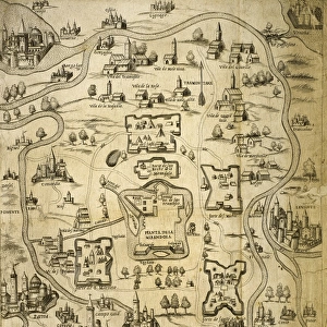
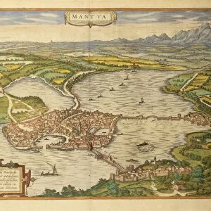
Glass Frame : Rimini, Italy. Theatrum Orbis Terrarum by Abraham Ortelis, 1


![]()
Mounted Prints from Mary Evans Picture Library
Rimini, Italy. Theatrum Orbis Terrarum by Abraham Ortelis, 1
Italy. Rimini city. Theatrum Orbis Terrarum by Abraham Ortelis, 1570. Library Estense. Modena. Italy
Mary Evans Picture Library makes available wonderful images created for people to enjoy over the centuries
Media ID 14337175
© Thaliastock / Mary Evans
1570 Abraham Adriatic Atlas Cartography Emilia Romagna Engraved Geographer Geography Orbis Ortelius Rimini Terrarum Theatrum
7"x5" Glass Mount
Wall mounted or free-standing, these black edged glass frames feature a smooth chamfered edge and a stylish black border (on back face of the glass). Manufactured from 4mm thick glass, Glass Mounts are a durable, professional way of displaying and protecting your prints. Your 7x5 print is slotted into the back of the frame so can easily be changed if needed.
Tempered Glass Mounts are ideal for wall display, plus the smaller sizes can also be used free-standing via an integral stand
Estimated Image Size (if not cropped) is 17.7cm x 12.7cm (7" x 5")
Estimated Product Size is 20.3cm x 16.2cm (8" x 6.4")
These are individually made so all sizes are approximate
Artwork printed orientated as per the preview above, with landscape (horizontal) orientation to match the source image.
EDITORS COMMENTS
This image is a rare and exquisite glimpse into the past, showcasing the Italian city of Rimini as it appeared in the late 16th century, as depicted in the renowned atlas "Theatrum Orbis Terrarum" by the Flemish cartographer Abraham Ortelius. The engraving, created in 1570, is part of the vast collection housed in the Library Estense in Modena, Italy. The meticulously detailed illustration highlights the strategic location of Rimini along the Adriatic Sea, nestled between the Emilia-Romagna region and the Apennine Mountains. The city's port is clearly visible, with ships anchored in the harbor, signaling the importance of maritime trade during this era. The intricate line work and vibrant colors bring to life the city's architectural gems, including the ancient Arch of Augustus and the imposing Malatesta Temple. This historical map offers a fascinating window into the world of 16th-century geography and cartography, providing a valuable record of the past and a testament to the artistic mastery of Abraham Ortelius.
MADE IN THE UK
Safe Shipping with 30 Day Money Back Guarantee
FREE PERSONALISATION*
We are proud to offer a range of customisation features including Personalised Captions, Color Filters and Picture Zoom Tools
SECURE PAYMENTS
We happily accept a wide range of payment options so you can pay for the things you need in the way that is most convenient for you
* Options may vary by product and licensing agreement. Zoomed Pictures can be adjusted in the Basket.