Glass Frame > Africa > Cameroon > Maps
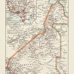
Glass Frame : Map Of The Cameroons, Scene Of One Of Britains Campaigns During World War One. From The Illustrated War News Published 1915


![]()
Mounted Prints from Design Pics
Map Of The Cameroons, Scene Of One Of Britains Campaigns During World War One. From The Illustrated War News Published 1915
Design Pics offers Distinctively Different Imagery representing over 1,500 contributors
Media ID 18190603
© Ken Welsh / Design Pics
Africa African Britains Colony First Geography German Mapmaking Retreat Warfare World Cameroon Cameroons Campaigns
7"x5" Glass Mount
Wall mounted or free-standing, these black edged glass frames feature a smooth chamfered edge and a stylish black border (on back face of the glass). Manufactured from 4mm thick glass, Glass Mounts are a durable, professional way of displaying and protecting your prints. Your 7x5 print is slotted into the back of the frame so can easily be changed if needed.
Tempered Glass Mounts are ideal for wall display, plus the smaller sizes can also be used free-standing via an integral stand
Estimated Image Size (if not cropped) is 12.7cm x 17.7cm (5" x 7")
Estimated Product Size is 16.2cm x 20.3cm (6.4" x 8")
These are individually made so all sizes are approximate
Artwork printed orientated as per the preview above, with portrait (vertical) orientation to match the source image.
FEATURES IN THESE COLLECTIONS
> Africa
> Cameroon
> Related Images
> Historic
> World War I and II
> World War I
> Maps and Charts
> Related Images
> Maps and Charts
> World
EDITORS COMMENTS
This print titled "Map Of The Cameroons, Scene Of One Of Britain's Campaigns During World War One" takes us back to the year 1915 when the world was engulfed in the chaos of war. Published in The Illustrated War News, this historical artifact offers a glimpse into one of Britain's significant military operations during World War I. The map showcases the region of Cameroons, known as Kamerun at that time, situated in Africa. It serves as a testament to the fierce battles fought between British and German forces for control over this strategic colony. As we observe closely, we can almost visualize the intense warfare that took place on these very lands. The image not only highlights the geographical features but also reflects upon the artistry and precision involved in mapmaking during those times. Every contour and detail has been meticulously captured by Ken Welsh, transporting us back to an era where maps played a crucial role in guiding troops through unfamiliar terrains. As we reflect upon this photograph print, it reminds us of the sacrifices made by countless individuals who fought bravely for their countries during World War I. It serves as a poignant reminder of how conflicts shape our history and impact nations far beyond their borders.
MADE IN THE UK
Safe Shipping with 30 Day Money Back Guarantee
FREE PERSONALISATION*
We are proud to offer a range of customisation features including Personalised Captions, Color Filters and Picture Zoom Tools
SECURE PAYMENTS
We happily accept a wide range of payment options so you can pay for the things you need in the way that is most convenient for you
* Options may vary by product and licensing agreement. Zoomed Pictures can be adjusted in the Basket.

![Henri-Victor de Rochefort-Lucay, [French politician and author], c. 1880](/sq/731/henri-victor-rochefort-lucay-french-politician-24036601.jpg.webp)