Glass Coaster > Europe > United Kingdom > Scotland > Roxburghshire
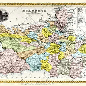
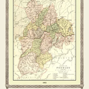
Glass Coaster : Old Map of the County of Roxburgh from the Philips Handy Atlas of 1882


![]()
Home Decor from MapSeeker
Old Map of the County of Roxburgh from the Philips Handy Atlas of 1882
PHA027
Welcome to the Mapseeker Image library and enter an historic gateway to one of the largest on-line collections of Historic Maps, Nostalgic Views, Vista's and Panorama's from a World gone by.
Media ID 20348193
County Map County Map Of Scotland Historic Map Old County Map Old Scottish County Map Scottish County Map Roxburgh Roxburghshire
Glass Coaster
Individual Glass Coaster. Stylish and elegant polished safety glass, toughened and heat resistant (10x10cm, 7mm thick). Price shown is per individual coaster.
Individual Glass Coaster. Elegant polished safety toughened glass and heat resistant, matching Place Mats are also available
Estimated Image Size (if not cropped) is 6.1cm x 7.6cm (2.4" x 3")
Estimated Product Size is 10cm x 10cm (3.9" x 3.9")
These are individually made so all sizes are approximate
Artwork printed orientated as per the preview above, with portrait (vertical) orientation to match the source image.
FEATURES IN THESE COLLECTIONS
> Europe
> United Kingdom
> Scotland
> Maps
> Europe
> United Kingdom
> Scotland
> Posters
> Europe
> United Kingdom
> Scotland
> Related Images
> Europe
> United Kingdom
> Scotland
> Roxburghshire
> Maps and Charts
> Early Maps
> Maps and Charts
> Related Images
> MapSeeker
> Maps from the British Isles
> Scotland and Counties PORTFOLIO
EDITORS COMMENTS
This print showcases an exquisite piece of history, the "Old Map of the County of Roxburgh from the Philips Handy Atlas of 1882 (PHA027)". Steeped in Scottish heritage, this vintage county map offers a fascinating glimpse into the past. With intricate details and delicate craftsmanship, this old Scottish county map transports us back to a bygone era. The rich hues and fine lines depict the boundaries and topography of Roxburghshire with remarkable accuracy. Every curve and contour tells a story, revealing how this region was once navigated. As we explore this historic map, we are reminded of Roxburgh's significance in Scotland's tapestry. Its strategic location near England made it a pivotal stronghold during turbulent times. This map serves as both an educational tool and a window into our ancestors' lives. Beyond its historical value, this old county map also captivates with its aesthetic appeal. The aged paper texture adds character while enhancing the nostalgic charm that emanates from every corner. Whether you're an avid collector or simply appreciate Scotland's rich heritage, this stunning print is sure to be cherished for generations to come. It invites us to immerse ourselves in the past and marvel at how far we've come since those early cartographic endeavors
MADE IN THE UK
Safe Shipping with 30 Day Money Back Guarantee
FREE PERSONALISATION*
We are proud to offer a range of customisation features including Personalised Captions, Color Filters and Picture Zoom Tools
SECURE PAYMENTS
We happily accept a wide range of payment options so you can pay for the things you need in the way that is most convenient for you
* Options may vary by product and licensing agreement. Zoomed Pictures can be adjusted in the Basket.