Glass Coaster > Europe > United Kingdom > Scotland > Edinburgh > Edinburgh
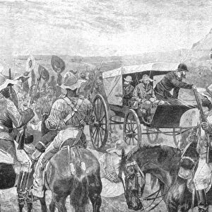
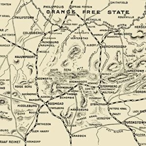
Glass Coaster : Map of the Seat of War, 1901. Creator: Unknown


![]()
Home Decor from Heritage Images
Map of the Seat of War, 1901. Creator: Unknown
Map of the Seat of War, 1901. From " South Africa and the Transvaal War, Vol. VI", by Louis Creswicke. [T. C. & E. C. Jack, Edinburgh, 1901]
Heritage Images features heritage image collections
Media ID 19781211
© The Print Collector/Heritage Images
1899 1902 2nd Boer War Bamp W Boer Wars Creswicke Jack Louis Louis Creswicke Occupied Territory Orange Free State Second Boer War Second Transvaal War South Africa South Africa And The Transvaal War South African Strategic Strategy Tc And Ec Tc And Ec Jack Territorial Territory Transvaal British Empire
Glass Coaster
Individual Glass Coaster. Stylish and elegant polished safety glass, toughened and heat resistant (10x10cm, 7mm thick). Price shown is per individual coaster.
Individual Glass Coaster. Elegant polished safety toughened glass and heat resistant, matching Place Mats are also available
Estimated Image Size (if not cropped) is 5.2cm x 7.6cm (2" x 3")
Estimated Product Size is 10cm x 10cm (3.9" x 3.9")
These are individually made so all sizes are approximate
Artwork printed orientated as per the preview above, with portrait (vertical) orientation to match the source image.
FEATURES IN THESE COLLECTIONS
> Africa
> Related Images
> Africa
> South Africa
> Maps
> Africa
> South Africa
> Related Images
> Arts
> Literature
> Europe
> United Kingdom
> Scotland
> Edinburgh
> Edinburgh
> Europe
> United Kingdom
> Scotland
> Lothian
> Edinburgh
> Maps and Charts
> British Empire Maps
> Maps and Charts
> Related Images
EDITORS COMMENTS
This print showcases a historical treasure, the "Map of the Seat of War, 1901". Created by an unknown artist and featured in Louis Creswicke's book "South Africa and the Transvaal War, Vol. VI" this map offers a glimpse into a crucial period in South African history. The image takes us back to the early 20th century when Britain was engaged in the Second Boer War. It depicts strategic locations, military occupation, and territorial boundaries during this turbulent time. The British Empire's efforts to expand its colonial influence are evident as they navigate through South African territories such as Transvaal and Orange Free State. As we explore this print, we can't help but appreciate its significance within Victorian literature and colonialism studies. Its detailed representation of occupied territory provides valuable insights into military strategies employed during that era. Preserved by The Print Collector, this remarkable piece serves as a reminder of our past struggles while also highlighting how far we have come since then. It invites us to reflect on the complexities of imperialism and its impact on countries like South Africa. Whether you're a history enthusiast or simply intrigued by maps from yesteryears, this fascinating print is sure to captivate your imagination with its rich historical context.
MADE IN THE UK
Safe Shipping with 30 Day Money Back Guarantee
FREE PERSONALISATION*
We are proud to offer a range of customisation features including Personalised Captions, Color Filters and Picture Zoom Tools
SECURE PAYMENTS
We happily accept a wide range of payment options so you can pay for the things you need in the way that is most convenient for you
* Options may vary by product and licensing agreement. Zoomed Pictures can be adjusted in the Basket.