Glass Coaster > North America > United States of America > New York > New York > Maps
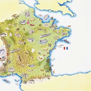
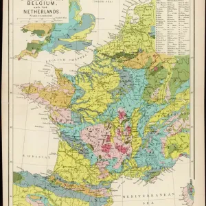
Glass Coaster : France map 1875


![]()
Home Decor from Fine Art Storehouse
France map 1875
The Independent Course Comprehensive Geography by James Monteith, A.S. Barnes & Co, New York & Chicago 1875
Unleash your creativity and transform your space into a visual masterpiece!
THEPALMER
Media ID 13612219
© This content is subject to copyright
Globe Navigational Equipment Paper
Glass Coaster
Individual Glass Coaster. Stylish and elegant polished safety glass, toughened and heat resistant (10x10cm, 7mm thick). Price shown is per individual coaster.
Individual Glass Coaster. Elegant polished safety toughened glass and heat resistant, matching Place Mats are also available
Estimated Image Size (if not cropped) is 7.6cm x 5.7cm (3" x 2.2")
Estimated Product Size is 10cm x 10cm (3.9" x 3.9")
These are individually made so all sizes are approximate
Artwork printed orientated as per the preview above, with landscape (horizontal) orientation to match the source image.
FEATURES IN THESE COLLECTIONS
> Fine Art Storehouse
> The Magical World of Illustration
> Palmer Illustrated Collection
> Fine Art Storehouse
> Map
> Historical Maps
> Maps and Charts
> Related Images
> North America
> United States of America
> Maps
> North America
> United States of America
> New York
> New York
> Maps
> North America
> United States of America
> New York
> Related Images
EDITORS COMMENTS
This print showcases a vintage France map from the year 1875, extracted from "The Independent Course Comprehensive Geography" by James Monteith. A true relic of its time, this exquisite piece was published by A. S. Barnes & Co in New York and Chicago during that era. The map itself is an intricate engraving on old paper, depicting the physical geography of France with remarkable detail. Transporting us back to a bygone era, this antique illustration offers a glimpse into the world of cartography as it existed over a century ago. Every line and contour has been meticulously engraved, capturing the essence of French topography with precision and artistry. Displayed horizontally, this print exudes an air of sophistication and historical significance. It serves as both a decorative item for any space and an educational tool for those fascinated by geography or history. The image also features elements such as navigational equipment and a globe, further emphasizing its connection to exploration and discovery. With THEPALMER's skillful photography capturing every nuance of this enchanting artwork, viewers are invited to immerse themselves in the rich heritage encapsulated within this stunning piece. Whether you're an avid collector or simply appreciate the beauty found in antiquity, this print is sure to captivate your imagination while adding timeless charm to any setting.
MADE IN THE UK
Safe Shipping with 30 Day Money Back Guarantee
FREE PERSONALISATION*
We are proud to offer a range of customisation features including Personalised Captions, Color Filters and Picture Zoom Tools
SECURE PAYMENTS
We happily accept a wide range of payment options so you can pay for the things you need in the way that is most convenient for you
* Options may vary by product and licensing agreement. Zoomed Pictures can be adjusted in the Basket.