Fraud Blocker Skip to main content

Oceanography Collection (page 2)

Oceanography is the fascinating study of Earth's vast and mysterious oceans

Background imageOceanography Collection: World Map showing Ocean Currents, 1902. Creator: Unknown

World Map showing Ocean Currents, 1902. Creator: Unknown
World Map showing Ocean Currents, 1902. From The Century Atlas of the World. [John Walker & Co, Ltd. London, 1902]

Background imageOceanography Collection: Artists impression of deep sea scene with luminous fishes, 1903

Artists impression of deep sea scene with luminous fishes, 1903. Some of the creatures shown here were brought up in the dredges during the French oceanographical expeditions of the Travailleur

Background imageOceanography Collection: Matthew Fontaine Maury, American naval officer, hydrographer and oceanographer, 1896

Matthew Fontaine Maury, American naval officer, hydrographer and oceanographer, 1896. Maury (1806-1873) was the founder of the US Naval Oceanographic Office

Background imageOceanography Collection: Circulation of water between sea and mountains, 1665

Circulation of water between sea and mountains, 1665. Blue-tinted flows are from mountains to the sea, while black represents flows taking water from whirlpools in the sea back to the mountains via

Background imageOceanography Collection: Albert I, Prince of Monaco (1848-1922), amateur oceanographer, 1900. Artist: Spy

Albert I, Prince of Monaco (1848-1922), amateur oceanographer, 1900. Artist: Spy
Albert I, Prince of Monaco (1848-1922), amateur oceanographer, 1900. Albert established the Oceanographic Museum of Monaco and the Oceanographic Institute in Paris

Background imageOceanography Collection: Alexandre Agassiz, Swiss-born American oceanographer, marine zoologist and mining engineer, 1883

Alexandre Agassiz, Swiss-born American oceanographer, marine zoologist and mining engineer, 1883. Alexandre Emmanuel Rodolphe Agassiz (1835-1910)

Background imageOceanography Collection: Illustration, the Nautile, yellow manned submersible owned by French Research Institute for

Illustration, the Nautile, yellow manned submersible owned by French Research Institute for Exploitation of the Sea, side view

Background imageOceanography Collection: A Liopleurodon attacks a Plesiosaurus

A Liopleurodon attacks a Plesiosaurus
A hapless Plesiosaurus becomes a meal for the much larger Liopleurodon aquatic reptile

Background imageOceanography Collection: North America, topographic map

North America, topographic map. Highlands and lowlands of the continents are also shown, as ridges and flat areas. South America (bottom right) and the Arctic (top) are also seen

Background imageOceanography Collection: Gulf steam bottles, used in scientific experiments to provide information about ocean currents

Gulf steam bottles, used in scientific experiments to provide information about ocean currents. From Longmans New Geographical Readers, published 1892

Background imageOceanography Collection: Oceanography

Oceanography
Sealife under the ocean including jellyfish, lobster and anemone. Date: 1930

Background imageOceanography Collection: Liopleurodon reptile hunting Ichthyosaurus dinosaurs in Jurassic seas

Liopleurodon reptile hunting Ichthyosaurus dinosaurs in Jurassic seas

Background imageOceanography Collection: Marine predators of the Cretaceous period

Marine predators of the Cretaceous period
Artists concept of primary marine predators that shared the ocean waters of the Western Interior Seaway of North America 75 million years ago

Background imageOceanography Collection: Leedsichthys fish about to swallow an Ichthyosaurus marine reptile

Leedsichthys fish about to swallow an Ichthyosaurus marine reptile. Leedsichthys is a large extinct fish from the Jurassic seas

Background imageOceanography Collection: Metriorhynchus marine reptiles try to capture a Coelacanth fish

Metriorhynchus marine reptiles try to capture a Coelacanth fish
Two Metriorhynchus marine reptiles try to capture a Coelacanth fish in Jurassic seas

Background imageOceanography Collection: Africa and Atlantic Ocean, with clouds C016 / 3727

Africa and Atlantic Ocean, with clouds C016 / 3727
Africa and Atlantic Ocean, with clouds. Computer graphic of an Earth globe centred on West Africa, generated using satellite and mapping data

Background imageOceanography Collection: South America, topographic map

South America, topographic map. Highlands and lowlands of the continents are also shown, as ridges and flat areas. North America and the Caribbean (top left) and Antarctica (bottom right)

Background imageOceanography Collection: Eurasia, topographic map

Eurasia, topographic map. This map is centred on Russia, with Europe at centre left and East Asia at right. The North Pole (upper left), with Greenland shown in white

Background imageOceanography Collection: Yucatan peninsula, south-eastern Mexico, separating the Gulf of Mexico from the Caribbean

Yucatan peninsula, south-eastern Mexico, separating the Gulf of Mexico from the Caribbean Sea photographed by Satellite. Credit NASA. Science Earth Geology Oceanography

Background imageOceanography Collection: Weedy Seadragon (Phyllopteryx taeniolatus), a long sea weed like dragon

Weedy Seadragon (Phyllopteryx taeniolatus), a long sea weed like dragon

Background imageOceanography Collection: True-color image of the entire Earth

True-color image of the entire Earth
This spectacular image is the most detailed true-color image of the entire Earth to date. Using a collection of satellite-based observations

Background imageOceanography Collection: January 2, 2009 - Cloud simulation of the full Earth

January 2, 2009 - Cloud simulation of the full Earth

Background imageOceanography Collection: Detailed satellite view of Earth

Detailed satellite view of Earth

Background imageOceanography Collection: January 2, 2009 - Cloud simulation of a single day centered over the western Pacific

January 2, 2009 - Cloud simulation of a single day centered over the western Pacific

Background imageOceanography Collection: Cylindrical equidistant projection of visualization showing clouds across the world

Cylindrical equidistant projection of visualization showing clouds across the world
January 2, 2009 - Cylindrical equidistant projection of visualization showing clouds across the world

Background imageOceanography Collection: A pod of iridescent red and blue jellyfish

A pod of iridescent red and blue jellyfish swim together in the vast ocean

Background imageOceanography Collection: A pod of Eurhinosaurus marine reptiles try to evade the much larger Liopleurodon

A pod of Eurhinosaurus marine reptiles try to evade the much larger Liopleurodon in Jurassic seas

Background imageOceanography Collection: Angelfish try to swim out of the reach of a Plesiosaurus dinosaur

Angelfish try to swim out of the reach of a Plesiosaurus dinosaur
An unlucky Redfin Angelfish tries to swim out of the reach of a Plesiosaurus dinosaur in the Jurassic Age

Background imageOceanography Collection: Group of Portuguese Man O War

Group of Portuguese Man O War
The Portuguese Man O War is a dangerous jellyfish which stings its prey with poisonous tentacles

Background imageOceanography Collection: Portuguese Man o War swarm over the surface of a Cambrian ocean

Portuguese Man o War swarm over the surface of a Cambrian ocean 500 million years ago. During the Cambrian period the Earths oceans were teaming with life

Background imageOceanography Collection: A school of Lemonpeel Angelfish swim by Plesiosaurus dinosaurs

A school of Lemonpeel Angelfish swim by Plesiosaurus dinosaurs
A school of Lemonpeel Angelfish keep a wary eye on three large predatory Plesiosaurus dinosaurs

Background imageOceanography Collection: Two Suchomimus dinosaurs search for big fish prey underwater

Two Suchomimus dinosaurs search for big fish prey underwater
Two Suchomimus dinosaurs dive and search for big fish prey to capture and eat

Background imageOceanography Collection: Plesiosaurus attacks a Metriorhynchus in Jurassic seas

Plesiosaurus attacks a Metriorhynchus in Jurassic seas
A Metriorhynchus becomes a meal for a Plesiosaurus marine reptile in blue Jurassic seas

Background imageOceanography Collection: A Eurhinosaurus reptile preys on a coelacanth fish

A Eurhinosaurus reptile preys on a coelacanth fish
A coelacanth fish becomes prey for a Eurhinosaurus marine reptile in a Jurassic ocean

Background imageOceanography Collection: A massive Shonisaurus attempts to make a meal of a school of squid-like Belemnites

A massive Shonisaurus attempts to make a meal of a school of squid-like Belemnites
A massive, 30-ton Shonisaurus, the largest known ichthyosaur (marine reptile) attempts to make a meal of a school of squid-like Belemnites

Background imageOceanography Collection: Liopleurodon eating an ammonite

Liopleurodon eating an ammonite. Liopleurodon are large carnivorous marine reptiles from the Jurassic era

Background imageOceanography Collection: A swarm of jellyfish swim the Panthalassic Ocean

A swarm of jellyfish swim the Panthalassic Ocean
A smack, or swarm, of jellyfish swim the Panthalassic Ocean 500 million years ago during the Cambrian Period. Jellyfish, also known as sea jellies

Background imageOceanography Collection: A pair of Elasmosaurus engage in a swimming courtship dance

A pair of Elasmosaurus engage in a swimming courtship dance
A pair of 40-foot-long Elasmosaurus engage in a swimming courtship dance in a secluded pool 80 million years ago in what is today North America

Background imageOceanography Collection: OCEAN DEPTHS, 1888. Map showing the depths of the Western Atlantic Basin and the Gulf of Mexico

OCEAN DEPTHS, 1888. Map showing the depths of the Western Atlantic Basin and the Gulf of Mexico, 1888

Background imageOceanography Collection: CURRENT METER, 1888. Pillsburys instrument for measuring ocean currents. Diagram, 1888

CURRENT METER, 1888. Pillsburys instrument for measuring ocean currents. Diagram, 1888

Background imageOceanography Collection: MATTHEW FONTAINE MAURY (1806-1873). American naval officer and oceanographer

MATTHEW FONTAINE MAURY (1806-1873). American naval officer and oceanographer. Title page of the first edition, 1855, of Maurys The Physical Geography of the Sea

Background imageOceanography Collection: HMS CHALLENGER, 1872-76. Watercolor drawing of HMS Challenger on the first page

HMS CHALLENGER, 1872-76. Watercolor drawing of HMS Challenger on the first page of the journal of the oceanographic voyage of 1872-76 kept by Lieutenant Pelham Aldrich, a member of the ships company

Background imageOceanography Collection: A chart of the east coast of America and the Gulf Stream, printed by Benjamin Franklin, 1786

A chart of the east coast of America and the Gulf Stream, printed by Benjamin Franklin, 1786
GULF STREAM CHART, 1786. A chart of the east coast of America and the Gulf Stream, printed by Benjamin Franklin, 1786

Background imageOceanography Collection: An early 19th century chart of the Gulf Stream according to the discoveries

An early 19th century chart of the Gulf Stream according to the discoveries and writings of Benjamin Franklin
GULF STREAM CHART. An early 19th century chart of the Gulf Stream according to the discoveries and writings of Benjamin Franklin

Background imageOceanography Collection: Illustration of four zones of plate tectonics: Sea-floor spreading

Illustration of four zones of plate tectonics: Sea-floor spreading, in which new earth crust is created as magma rises;
GEOLOGY: PLATE TECTONICS. Illustration of four zones of plate tectonics: Sea-floor spreading, in which new earth crust is created as magma rises; subduction zone in which a seafloor plate descends

Background imageOceanography Collection: (1806-1873). American naval officer and oceanographer. Geological agency of the winds

(1806-1873). American naval officer and oceanographer. Geological agency of the winds
MATTHEW FONTAINE MAURY (1806-1873). American naval officer and oceanographer. Geological agency of the winds. Engraved plate from the first edition of Maurys The Physical Geography of the Sea, 1855

Background imageOceanography Collection: Credit Image courtesy: MODIS Ocean Group, NASA GSFC, and the University of Miami

Credit Image courtesy: MODIS Ocean Group, NASA GSFC, and the University of Miami
Credit Image courtesy:MODIS Ocean Group, NASA GSFC, and the University of Miami: sea surface temperature shown in false-colour image. a one-month composite for May 2001

Background imageOceanography Collection: Circulation of water between sea and mountains. Blue-tinted flows are mountains to sea

Circulation of water between sea and mountains. Blue-tinted flows are mountains to sea, black represents subterranean flows from sea to mountains. From Athanasius Kircher Mundus Subterraneous, 1665


All Professionally Made to Order for Quick Shipping

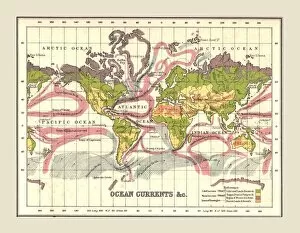
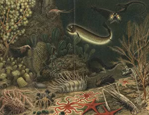
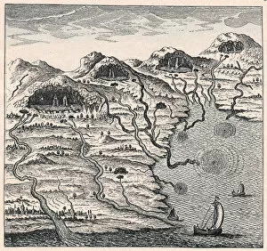
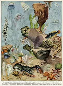
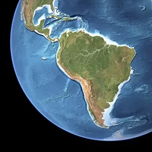
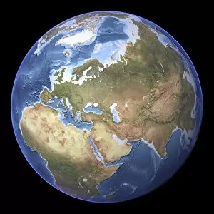
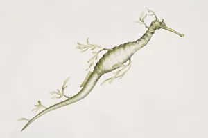
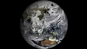
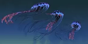
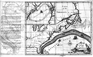
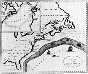
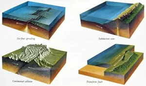
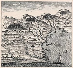
Oceanography is the fascinating study of Earth's vast and mysterious oceans. Through the use of topographic and bathymetric maps, scientists are able to explore the intricate features that make up our planet's watery depths. These maps provide a detailed understanding of both the land and seafloor, giving us insight into how they interact with one another. One area of focus is studying ocean currents off the Americas. By analyzing these powerful flows of water, researchers can better comprehend their impact on climate patterns and marine life distribution. This knowledge helps us navigate and understand our ever-changing world. Delving into history, we discover undersea exploration in 16th-century Europe played a crucial role in shaping modern oceanography. Pioneers like Jacques Cousteau paved the way for future generations to delve deeper into uncharted territories beneath the waves. Australia's topographic map reveals its unique coastal geography, showcasing its stunning beaches and diverse marine ecosystems. Understanding these features aids scientists in preserving this fragile environment for future generations to enjoy. The submersible Alvin with its silver body and control arms has revolutionized underwater research by allowing scientists to reach extreme depths previously inaccessible. Its advanced technology enables us to unravel mysteries hidden deep within our oceans. A flat projection map created from satellite images provides an awe-inspiring view of Earth as seen from space, highlighting just how much of our planet is covered by water. It serves as a reminder that oceans play a vital role in maintaining global balance. Charting specific sections such as Madeira, Portugal to St. Vincent allows researchers to gather valuable data about local currents, temperatures, and biodiversity hotspots along this stretch of coastline - essential information for conservation efforts. Intriguing creatures like box jellyfish captivate both scientists and enthusiasts alike due to their ethereal beauty but also their potent venomous sting - reminding us that there is still so much left undiscovered beneath the surface. A field that encompasses all these elements and more.