Fraud Blocker Skip to main content

1681 1799 Collection

"Exploring the Baltic

Background image1681 1799 Collection: Sea chart of the southern part of the Baltic Sea, print maker: Jan Luyken, Johannes

Sea chart of the southern part of the Baltic Sea, print maker: Jan Luyken, Johannes van Keulen I, unknown, 1681 - 1799

Background image1681 1799 Collection: Sea chart of the northwestern part of the Baltic Sea by the Swedish coast, Jan Luyken

Sea chart of the northwestern part of the Baltic Sea by the Swedish coast, Jan Luyken, Johannes van Keulen (I), unknown, 1681 - 1799

Background image1681 1799 Collection: Sea chart of the Northern Dvina River, Jan Luyken, Johannes van Keulen (I), unknown

Sea chart of the Northern Dvina River, Jan Luyken, Johannes van Keulen (I), unknown, 1681 - 1799

Background image1681 1799 Collection: Sea chart of the Northern Dvina River, Russia, Jan Luyken, Johannes van Keulen I

Sea chart of the Northern Dvina River, Russia, Jan Luyken, Johannes van Keulen I, unknown, 1681-1799

Background image1681 1799 Collection: Map of the waters around Stockholm, Jan Luyken, Johannes van Keulen (I), unknown

Map of the waters around Stockholm, Jan Luyken, Johannes van Keulen (I), unknown, 1681 - 1799

Background image1681 1799 Collection: Sea chart of the mouth of the Gulf of Finland in the Baltic Sea, Jan Luyken, Johannes

Sea chart of the mouth of the Gulf of Finland in the Baltic Sea, Jan Luyken, Johannes van Keulen (I), unknown, 1681 - 1799

Background image1681 1799 Collection: Sea chart of a portion of the Baltic coast of Poland and Latvia, Jan Luyken, Johannes

Sea chart of a portion of the Baltic coast of Poland and Latvia, Jan Luyken, Johannes van Keulen (I), unknown, 1681 - 1799

Background image1681 1799 Collection: Map of the eastern part of the Gulf of Finland, Johannes van Keulen (I), unknown

Map of the eastern part of the Gulf of Finland, Johannes van Keulen (I), unknown, 1681 - 1799

Background image1681 1799 Collection: Sea chart of Northern part of Atlantic and Arctic Ocean, North Sea and Baltic Sea

Sea chart of Northern part of Atlantic and Arctic Ocean, North Sea and Baltic Sea, Jan Luyken, Johannes van Keulen I, unknown, 1681-1799

Background image1681 1799 Collection: Sea chart of part of the coast of Finnmark, Jan Luyken, Johannes van Keulen (I), unknown

Sea chart of part of the coast of Finnmark, Jan Luyken, Johannes van Keulen (I), unknown, 1681 - 1799

Background image1681 1799 Collection: Sea chart of part of the Norwegian coast, Norway, print maker: Jan Luyken, Johannes

Sea chart of part of the Norwegian coast, Norway, print maker: Jan Luyken, Johannes van Keulen I, unknown, 1681 - 1799

Background image1681 1799 Collection: Sea chart of part of the coast of the Kola peninsula in Russia, Jan Luyken, Johannes van Keulen

Sea chart of part of the coast of the Kola peninsula in Russia, Jan Luyken, Johannes van Keulen (I), unknown, 1681 - 1799

Background image1681 1799 Collection: Three-piece waiver of Iceland, Jan Mayen Island and Spitsbergen, Jan Luyken, Johannes

Three-piece waiver of Iceland, Jan Mayen Island and Spitsbergen, Jan Luyken, Johannes van Keulen I, unknown, 1681 - 1799

Background image1681 1799 Collection: Sea chart of part of the White Sea in Russia, Jan Luyken, Johannes van Keulen (I)

Sea chart of part of the White Sea in Russia, Jan Luyken, Johannes van Keulen (I), unknown, 1681-1799

Background image1681 1799 Collection: Sea chart of the Baltic and North Sea, Jan Luyken, Johannes van Keulen (I), unknown

Sea chart of the Baltic and North Sea, Jan Luyken, Johannes van Keulen (I), unknown, 1681 - 1799

Background image1681 1799 Collection: Sea chart of the Wadden Sea from Den Helder to Terschelling, Jan Luyken, Johannes van Keulen

Sea chart of the Wadden Sea from Den Helder to Terschelling, Jan Luyken, Johannes van Keulen (I), unknown, 1681 - 1799

Background image1681 1799 Collection: Sea chart of a large part of the Wadden, Jan Luyken, Johannes van Keulen (I), unknown

Sea chart of a large part of the Wadden, Jan Luyken, Johannes van Keulen (I), unknown, 1681 - 1799

Background image1681 1799 Collection: Sea chart of part of the Elbe, the Weser and Jadebusen, Jan Luyken, Johannes van Keulen I

Sea chart of part of the Elbe, the Weser and Jadebusen, Jan Luyken, Johannes van Keulen I, unknown, 1681 - 1799

Background image1681 1799 Collection: Sea chart of part of the coast of Norway and Jutland, Jan Luyken, Johannes van Keulen (I)

Sea chart of part of the coast of Norway and Jutland, Jan Luyken, Johannes van Keulen (I), unknown, 1681-1799

Background image1681 1799 Collection: Sea chart of the coast of Norway, Jan Luyken, Johannes van Keulen (I), unknown, 1681

Sea chart of the coast of Norway, Jan Luyken, Johannes van Keulen (I), unknown, 1681 - 1799

Background image1681 1799 Collection: Sea chart of the Danish Islands, part of the coast of Sweden and Germany, Jan Luyken

Sea chart of the Danish Islands, part of the coast of Sweden and Germany, Jan Luyken, Johannes van Keulen I, unknown, 1681-1799

Background image1681 1799 Collection: Sea chart of Denmark in the Skagerrak and Kattegat, Jan Luyken, Johannes van Keulen I

Sea chart of Denmark in the Skagerrak and Kattegat, Jan Luyken, Johannes van Keulen I, unknown, 1681-1799

Background image1681 1799 Collection: Sea chart of part of the coast of Norway, print maker: Jan Luyken, Johannes van Keulen I

Sea chart of part of the coast of Norway, print maker: Jan Luyken, Johannes van Keulen I, unknown, 1681 - 1799

Background image1681 1799 Collection: Sea chart of part of the coast of Norway near Bergen, Jan Luyken, Johannes van Keulen I

Sea chart of part of the coast of Norway near Bergen, Jan Luyken, Johannes van Keulen I, unknown, 1681 - 1799

Background image1681 1799 Collection: Sea chart of the east coast of England, with the mouth of the Humber, Jan Luyken

Sea chart of the east coast of England, with the mouth of the Humber, Jan Luyken, Johannes van Keulen (I), unknown, 1681 - 1799

Background image1681 1799 Collection: Sea chart of the coast of Norway near Trondheim, Jan Luyken, Johannes van Keulen (I)

Sea chart of the coast of Norway near Trondheim, Jan Luyken, Johannes van Keulen (I), unknown, 1681 - 1799

Background image1681 1799 Collection: Sea chart of part of the northeast coast of England and part of Scotland, Jan Luyken

Sea chart of part of the northeast coast of England and part of Scotland, Jan Luyken, Johannes van Keulen (I), unknown, 1681 - 1799

Background image1681 1799 Collection: Sea chart of the Baltic Sea from Rostock to Vyborg, Jan Luyken, Johannes van Keulen (I)

Sea chart of the Baltic Sea from Rostock to Vyborg, Jan Luyken, Johannes van Keulen (I), unknown, 1681 - 1799

Background image1681 1799 Collection: Sea chart of part of north east coast of Scotland and the Orkney Islands, Jan Luyken

Sea chart of part of north east coast of Scotland and the Orkney Islands, Jan Luyken, Johannes van Keulen I, unknown, 1681-1799


All Professionally Made to Order for Quick Shipping

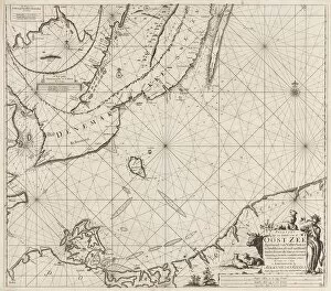
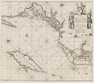
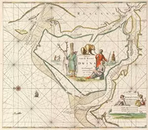
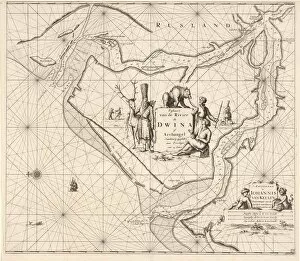
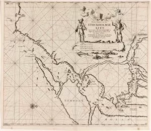
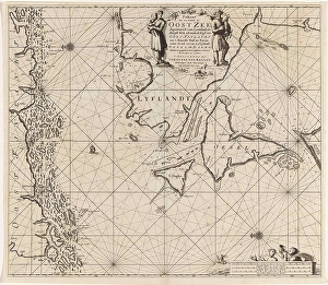
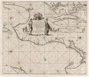
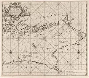
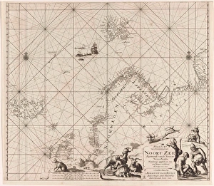
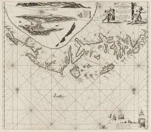
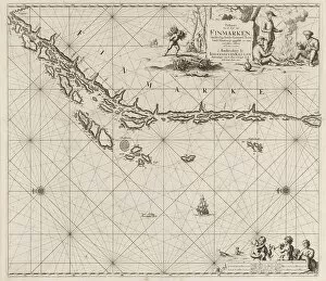
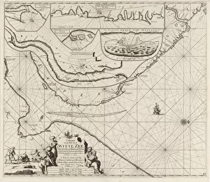
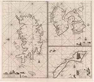
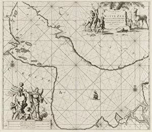
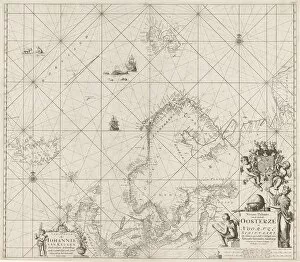
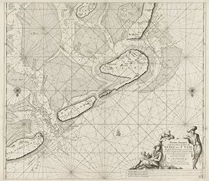
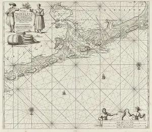
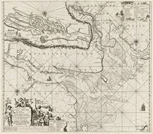
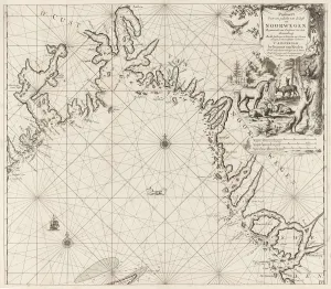
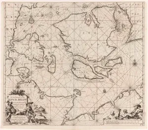
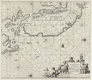
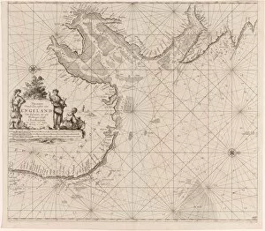
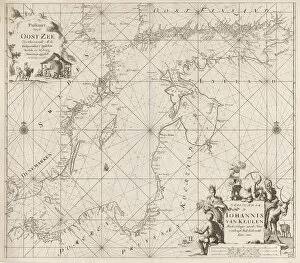
"Exploring the Baltic: Jan Luyken and Johannes van Keulen's Sea Charts (1681-1799)" Step back in time as we dive into the remarkable sea charts created by Dutch printmaker Jan Luyken and cartographer Johannes van Keulen. From the southern part of the Baltic Sea to the Arctic Ocean, their intricate maps provide a glimpse into maritime exploration during the late 17th and 18th centuries. In their "Sea chart of the southern part of the Baltic Sea, " Luyken and Van Keulen meticulously depict navigational routes, coastal landmarks, and even underwater topography. Sailors relied on these detailed charts to safely navigate treacherous waters. Moving northward, we encounter another masterpiece – "Sea chart of the northwestern part of the Baltic Sea by Swedish coast. " This map showcases Sweden's coastline with precision, highlighting key ports and islands along its shores. It served as an invaluable resource for both traders and naval forces during this era. Venturing further eastward, our journey takes us to Russia's Northern Dvina River. Here, Luyken collaborates once again with Van Keulen in creating two distinct sea charts. These maps reveal vital information about river currents, depths, and nearby settlements – essential knowledge for those navigating this strategic waterway. As we sail southwards towards Stockholm, Sweden's capital city comes alive on Luyken and Van Keulen's "Map of waters around Stockholm. " This intricately designed chart offers a comprehensive view of surrounding archipelagos while guiding mariners through narrow channels leading to one of Scandinavia's most important trading hubs. Our voyage continues westward as we explore "The mouth of Gulf Finland in The Baltic Sea. " With its accurate representation of coastal features such as capes and bays, this map facilitated safe passage through these challenging waters connecting Russia with Europe.