Home > Arts > Artists > K > Johannes van Keulen
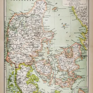
Sea chart of Denmark in the Skagerrak and Kattegat, Jan Luyken, Johannes van Keulen I

![]()
Wall Art and Photo Gifts from Liszt Collection
Sea chart of Denmark in the Skagerrak and Kattegat, Jan Luyken, Johannes van Keulen I
Sea chart of Denmark in the Skagerrak and Kattegat, Jan Luyken, Johannes van Keulen I, unknown, 1681-1799
Liszt Collection of nineteenth-century engravings and images to browse and enjoy
Media ID 12716335
© Quint Lox Limited
1681 1799 Address Amores Amoretti Buck Cartouche Chariot Compass Compass Rose Cupids Denmark Framed French Miles Goat Holding Jan Luyken Johannes Van Keulen Miles Neptune North Picture Poseidon Putti Rose Scale Sea Chart Spanish Stone Chart Kattegat Skagerrak
FEATURES IN THESE COLLECTIONS
> Animals
> Insects
> Hemiptera
> Rose Scale
> Arts
> Artists
> K
> Johannes van Keulen
> Arts
> Artists
> L
> Jan Luyken
> Maps and Charts
> World
EDITORS COMMENTS
This print showcases a remarkable sea chart of Denmark in the Skagerrak and Kattegat, created by renowned cartographers Jan Luyken and Johannes van Keulen I. Dating back to the 17th or 18th century, this exquisite piece of art captures the essence of maritime exploration during that era. The intricate details on this map are truly awe-inspiring. From mythical figures like Neptune and Poseidon to adorable cherubs known as cupids, amores, amoretti, and putti, every element adds a touch of enchantment to the composition. A majestic chariot pulled by a goat symbolizes adventure across uncharted waters. The accuracy and precision depicted in this sea chart reflect the mastery of these German-Spanish-Dutch-French-English cartographers. The compass rose points northward while an ornate cartouche provides essential information about geographical coordinates. The scale is measured in French miles, offering insight into historical navigation techniques. Framed elegantly with attention to detail, this picture print is a testament to both artistic beauty and scientific knowledge. It serves as a window into Denmark's maritime history while also showcasing advancements in cartography during that period. Whether you're an avid collector or simply appreciate the wonders of geography and history, this framed sea chart will undoubtedly captivate your imagination. Its presence on any wall will transport you back in time when intrepid explorers braved unknown seas with nothing but their trusty compasses at hand.
MADE IN THE UK
Safe Shipping with 30 Day Money Back Guarantee
FREE PERSONALISATION*
We are proud to offer a range of customisation features including Personalised Captions, Color Filters and Picture Zoom Tools
SECURE PAYMENTS
We happily accept a wide range of payment options so you can pay for the things you need in the way that is most convenient for you
* Options may vary by product and licensing agreement. Zoomed Pictures can be adjusted in the Basket.