Home > Arts > Artists > K > Johannes van Keulen
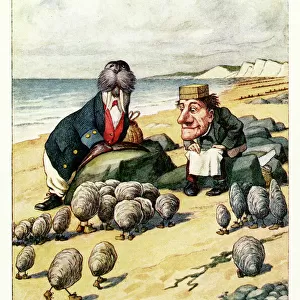
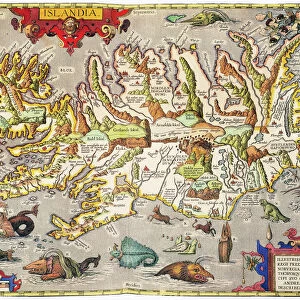
Sea chart of Northern part of Atlantic and Arctic Ocean, North Sea and Baltic Sea

![]()
Wall Art and Photo Gifts from Liszt Collection
Sea chart of Northern part of Atlantic and Arctic Ocean, North Sea and Baltic Sea
Sea chart of Northern part of Atlantic and Arctic Ocean, North Sea and Baltic Sea, Jan Luyken, Johannes van Keulen I, unknown, 1681-1799
Liszt Collection of nineteenth-century engravings and images to browse and enjoy
Media ID 12716479
© Quint Lox Limited
1681 1799 Archers Weapons Arctic Arctic Ocean Arrow Atlantic Baltic Bear Beasts Prey Bow Arrow Coast Compass Compass Roses Deer French Miles Goat Iceland Jan Luyken Johannes Van Keulen Milking North North Sea Northern Nova Ocean Pointing Predatory Animals Rocky Rocky Landscape Roses Scenic Sea Chart Sleigh Swimming Mammals Walrus Chart Nova Zembla Skis
FEATURES IN THESE COLLECTIONS
> Animals
> Mammals
> Odobenidae
> Walrus
> Arts
> Artists
> K
> Johannes van Keulen
> Arts
> Artists
> L
> Jan Luyken
> Maps and Charts
> World
EDITORS COMMENTS
This print showcases a remarkable sea chart of the Northern part of the Atlantic and Arctic Ocean, as well as the North Sea and Baltic Sea. Created by renowned cartographers Jan Luyken and Johannes van Keulen I between 1681 and 1799, this map is a true masterpiece of geographical accuracy. The intricate details on this chart are truly awe-inspiring. From compass roses guiding sailors to rocky landscapes along the coastlines, every element has been meticulously depicted. The inclusion of various predatory animals such as bears and swimming mammals adds an intriguing touch to this historical piece. Intriguingly, amidst this vast expanse lies a man with skis on his feet, traversing through icy terrain. A woman can be seen milking a goat nearby while pointing towards something in the distance. A sleigh pulled by deer stands ready for its journey ahead. The presence of archers' weapons like bows and arrows hints at both protection from potential threats and hunting opportunities in these remote regions. The French mile markers provide insight into navigation techniques used during that era. As we delve into Quint Lox's interpretation of this artwork from Liszt Collection, we are transported back in time to an era where exploration was paramount. This print not only captures history but also invites us to appreciate the beauty and complexity of our world's oceans and their surrounding landscapes.
MADE IN THE UK
Safe Shipping with 30 Day Money Back Guarantee
FREE PERSONALISATION*
We are proud to offer a range of customisation features including Personalised Captions, Color Filters and Picture Zoom Tools
SECURE PAYMENTS
We happily accept a wide range of payment options so you can pay for the things you need in the way that is most convenient for you
* Options may vary by product and licensing agreement. Zoomed Pictures can be adjusted in the Basket.