Home > Arts > Artists > K > Johannes van Keulen
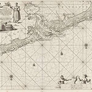
Sea chart of the Wadden Sea from Den Helder to Terschelling, Jan Luyken, Johannes van Keulen

![]()
Wall Art and Photo Gifts from Liszt Collection
Sea chart of the Wadden Sea from Den Helder to Terschelling, Jan Luyken, Johannes van Keulen
Sea chart of the Wadden Sea from Den Helder to Terschelling, Jan Luyken, Johannes van Keulen (I), unknown, 1681 - 1799
Liszt Collection of nineteenth-century engravings and images to browse and enjoy
Media ID 12716377
© Quint Lox Limited
1681 1799 Address Atlases Cartouche Compass Compasses French Miles Instruments Jan Luyken Johannes Van Keulen Lead Maps Miles North Roses Sailors Scale Sea Chart Seaman Spanish Wadden Sea Chart Den Helder Helder Terschelling Wadden
FEATURES IN THESE COLLECTIONS
> Animals
> Insects
> Hemiptera
> Rose Scale
> Arts
> Artists
> K
> Johannes van Keulen
> Arts
> Artists
> L
> Jan Luyken
> Maps and Charts
> World
EDITORS COMMENTS
This print showcases a remarkable sea chart of the Wadden Sea, stretching from Den Helder to Terschelling. Created by renowned cartographers Jan Luyken and Johannes van Keulen between 1681 and 1799, this intricate map is a testament to their mastery in the field of geography. The chart depicts the vast expanse of the Wadden Sea with meticulous detail, capturing its geographical features and navigational routes. Sailors and seamen relied on such maps to navigate these treacherous waters, making it an invaluable tool for maritime exploration. Intriguingly, amidst the wealth of information presented on this chart, we spot a seaman accompanied by his loyal canine companion. This inclusion adds a touch of humanity to an otherwise technical representation. The presence of compasses and other instruments further emphasizes the importance placed on accurate navigation during that era. With its elegant cartouche displaying addresses in German, Spanish, English, and French miles, this sea chart served as an essential resource for sailors from various nations. It not only facilitated safe passage but also fostered international cooperation among seafarers. Quint Lox's expert photography captures every minute detail of this historical artifact while preserving its rich colors and textures. As we gaze upon this print from Liszt Collection, we are transported back in time to witness the ingenuity behind early cartography—a true testament to human curiosity about our world's oceans and lands.
MADE IN THE UK
Safe Shipping with 30 Day Money Back Guarantee
FREE PERSONALISATION*
We are proud to offer a range of customisation features including Personalised Captions, Color Filters and Picture Zoom Tools
SECURE PAYMENTS
We happily accept a wide range of payment options so you can pay for the things you need in the way that is most convenient for you
* Options may vary by product and licensing agreement. Zoomed Pictures can be adjusted in the Basket.