Framed Print > Universal Images Group (UIG) > Universal Images Group > Satellite and Aerial > Planet Observer 6
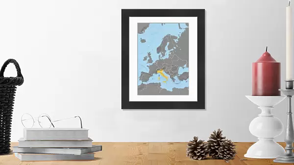
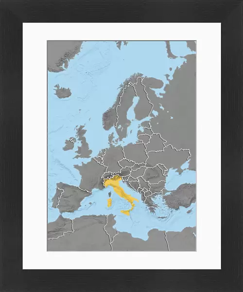
Framed Print : Europe, Relief Map With Country Borders


![]()
Framed Photos from Universal Images Group (UIG)
Europe, Relief Map With Country Borders
Relief map of Bosnia and Herzegovina in Europe with country borders. This map was processed from elevation data
Universal Images Group (UIG) manages distribution for many leading specialist agencies worldwide
Media ID 9615609
© Planet Observer
Alsace Bas Rhin Geographical Border Relief Map Satellite View
14"x12" (38x32cm) Modern Frame
Discover the beauty of Europe's diverse terrain with our Framed Prints from Media Storehouse. This stunning relief map, sourced from Universal Images Group (UIG), showcases the intricate country borders of Europe with breathtaking detail. Processed from elevation data, each print offers a unique perspective on the continent's geography. Add this captivating piece to your home or office décor and let the story of Europe's rich history unfold before your eyes.
Wood effect frame, card mounted, 10x8 archival quality photo print. Overall outside dimensions 14x12 inches (38x32cm). Environmentally and ozone friendly, 40mm wide x 15mm Polycore® moulding has the look of real wood, is durable and light and easy to hang. Biodegradable and made with non-chlorinated gases (no toxic fumes) it is efficient; producing 100 tons of polystyrene can save 300 tons of trees! Prints are glazed with lightweight, shatterproof, optical clarity acrylic (providing the same general protection from the environment as glass). The back is stapled hardboard with a sawtooth hanger attached. Note: To minimise original artwork cropping, for optimum layout, and to ensure print is secure, the visible print may be marginally smaller
Contemporary Framed and Mounted Prints - Professionally Made and Ready to Hang
Estimated Image Size (if not cropped) is 17.3cm x 24.4cm (6.8" x 9.6")
Estimated Product Size is 32.5cm x 37.6cm (12.8" x 14.8")
These are individually made so all sizes are approximate
Artwork printed orientated as per the preview above, with portrait (vertical) orientation to match the source image.
EDITORS COMMENTS
This print showcases the intricate details of Europe's relief map, specifically highlighting Bosnia and Herzegovina with its distinct country borders. Processed from elevation data, this topographic masterpiece offers a unique perspective on the physical geography of the region. The satellite view adds an extra layer of authenticity to the image, allowing viewers to appreciate the natural contours and features that shape this part of Europe. The vibrant colors used in this photograph bring life to an otherwise technical representation of landforms. With no people present in the frame, one can fully immerse themselves in studying every geographical border and contour line etched into the landscape. From towering mountains to sprawling valleys, each element is meticulously captured by Universal Images Group (UIG), ensuring a visually stunning portrayal. As you gaze upon this vertical composition, your eyes are drawn towards Bosnia and Herzegovina's diverse terrain—a testament to nature's artistry at work. This print serves as a valuable tool for cartographers or anyone interested in exploring Europe's physical characteristics up close. Whether you're an avid traveler seeking inspiration or a student delving into geographical studies, this image will undoubtedly ignite curiosity about our planet's remarkable diversity
MADE IN THE UK
Safe Shipping with 30 Day Money Back Guarantee
FREE PERSONALISATION*
We are proud to offer a range of customisation features including Personalised Captions, Color Filters and Picture Zoom Tools
SECURE PAYMENTS
We happily accept a wide range of payment options so you can pay for the things you need in the way that is most convenient for you
* Options may vary by product and licensing agreement. Zoomed Pictures can be adjusted in the Basket.