Framed Print > Universal Images Group (UIG) > Universal Images Group > Satellite and Aerial > Planet Observer 4
Framed Print : Departement of Seine-Maritime, France, Relief Map


![]()
Framed Photos from Universal Images Group (UIG)
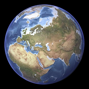
Departement of Seine-Maritime, France, Relief Map
Relief map of the departement of Seine-Maritime in Upper Normandy, France. It is situated on the northern coast of France, at the mouth of the River Seine. This image was compiled from data acquired by LANDSAT 5 & 7 satellites combined with elevation data
Universal Images Group (UIG) manages distribution for many leading specialist agencies worldwide
Media ID 9608145
© Planet Observer/UIG
Coastline English Channel Eure Relief Map Rouen Shore Upper Normandy Satellite View Seine Maritime
14"x12" (38x32cm) Modern Frame
Discover the beauty of Upper Normandy with our exquisite Framed Print of the Departement of Seine-Maritime from Media Storehouse. This stunning relief map, sourced from Universal Images Group (UIG), showcases the intricate topography of the region, located on the northern coast of France at the mouth of the River Seine. Bring a piece of France into your home or office with this captivating and detailed representation of the Department. Order yours today and let the adventure begin!
Wood effect frame, card mounted, 10x8 archival quality photo print. Overall outside dimensions 14x12 inches (38x32cm). Environmentally and ozone friendly, 40mm wide x 15mm Polycore® moulding has the look of real wood, is durable and light and easy to hang. Biodegradable and made with non-chlorinated gases (no toxic fumes) it is efficient; producing 100 tons of polystyrene can save 300 tons of trees! Prints are glazed with lightweight, shatterproof, optical clarity acrylic (providing the same general protection from the environment as glass). The back is stapled hardboard with a sawtooth hanger attached. Note: To minimise original artwork cropping, for optimum layout, and to ensure print is secure, the visible print may be marginally smaller
Contemporary Framed and Mounted Prints - Professionally Made and Ready to Hang
Estimated Image Size (if not cropped) is 17.3cm x 24.4cm (6.8" x 9.6")
Estimated Product Size is 32.5cm x 37.6cm (12.8" x 14.8")
These are individually made so all sizes are approximate
Artwork printed orientated as per the preview above, with portrait (vertical) orientation to match the source image.
FEATURES IN THESE COLLECTIONS
> Universal Images Group (UIG)
> Universal Images Group
> Satellite and Aerial
> Planet Observer 4
> Universal Images Group (UIG)
> Universal Images Group
> Satellite and Aerial
> Planet Observer 6
EDITORS COMMENTS
This print showcases the exquisite beauty of the Departement of Seine-Maritime in Upper Normandy, France. The relief map provides a detailed depiction of this region's topography, highlighting its unique geographical features. Situated on the northern coast of France, at the mouth of the majestic River Seine, this area boasts an enchanting shoreline along the English Channel. Compiled from data acquired by LANDSAT 5 & 7 satellites combined with elevation data, this image offers a satellite view that unveils an intricate tapestry of colors and contours. The vibrant hues and precise cartography allow viewers to immerse themselves in the physical geography of this remarkable region. With no people present in this photograph, it allows us to focus solely on appreciating nature's wonders. From Rouen to Eure and beyond, every inch is meticulously captured in stunning detail. This vertical composition invites exploration as one traces their gaze across each valley and peak. As we delve into this visual masterpiece, we are reminded that photography has a profound ability to transport us instantly to distant lands. Through Universal Images Group (UIG), we have been granted access to witness firsthand the breathtaking landscapes that grace our planet. Let your imagination soar as you marvel at this extraordinary relief map capturing Upper Normandy's essence – an outdoor paradise where land meets sea along its picturesque coastline.
MADE IN THE UK
Safe Shipping with 30 Day Money Back Guarantee
FREE PERSONALISATION*
We are proud to offer a range of customisation features including Personalised Captions, Color Filters and Picture Zoom Tools
SECURE PAYMENTS
We happily accept a wide range of payment options so you can pay for the things you need in the way that is most convenient for you
* Options may vary by product and licensing agreement. Zoomed Pictures can be adjusted in the Basket.