Framed Print > Universal Images Group (UIG) > Universal Images Group > Satellite and Aerial > Planet Observer 6
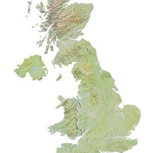
Framed Print : Asia, Relief Map With Country Borders


![]()
Framed Photos from Universal Images Group (UIG)
Asia, Relief Map With Country Borders
Relief map of Philippines in Asia with country borders. This map was processed from elevation data
Universal Images Group (UIG) manages distribution for many leading specialist agencies worldwide
Media ID 9612405
© Planet Observer
Alsace Bas Rhin Geographical Border Relief Map Satellite View
14"x12" (38x32cm) Modern Frame
Discover the beauty and complexity of Asia with our stunning Framed Print from Media Storehouse and Universal Images Group. This exquisite relief map showcases the intricate country borders of Asia, with a focus on the Philippines. Meticulously crafted from elevation data, each contour and terrain is rendered in crisp detail, making it an essential addition to any home or office decor. Elevate your space with this captivating representation of the diverse Asian continent.
Wood effect frame, card mounted, 10x8 archival quality photo print. Overall outside dimensions 14x12 inches (38x32cm). Environmentally and ozone friendly, 40mm wide x 15mm Polycore® moulding has the look of real wood, is durable and light and easy to hang. Biodegradable and made with non-chlorinated gases (no toxic fumes) it is efficient; producing 100 tons of polystyrene can save 300 tons of trees! Prints are glazed with lightweight, shatterproof, optical clarity acrylic (providing the same general protection from the environment as glass). The back is stapled hardboard with a sawtooth hanger attached. Note: To minimise original artwork cropping, for optimum layout, and to ensure print is secure, the visible print may be marginally smaller
Contemporary Framed and Mounted Prints - Professionally Made and Ready to Hang
Estimated Image Size (if not cropped) is 24.4cm x 17.3cm (9.6" x 6.8")
Estimated Product Size is 37.6cm x 32.5cm (14.8" x 12.8")
These are individually made so all sizes are approximate
Artwork printed orientated as per the preview above, with landscape (horizontal) orientation to match the source image.
EDITORS COMMENTS
This stunning print captures the intricate and diverse topography of Asia, specifically highlighting the relief map of the Philippines within its continental borders. Processed from elevation data, this map showcases the remarkable physical geography of the region. The vibrant colors and meticulous detailing bring to life every mountain range, valley, and coastline with astonishing clarity. The satellite view offers a unique perspective on this vast landmass, allowing us to appreciate its sheer magnitude and complexity. As we gaze upon this image, we are reminded of the rich cultural heritage that thrives across Asia's diverse nations. From bustling metropolises to serene rural landscapes, each country within these borders boasts its own unique identity. With no people in sight, our focus is solely on nature's grandeur as it unfolds before us. This photograph serves as a testament to mankind's ability to capture and understand our planet's ever-changing landscape through cartography. Displayed vertically like an artistic masterpiece against a backdrop of Bas Rhin in France’s Alsace region, this print invites us into a world where geographical boundaries dissolve into awe-inspiring beauty. It reminds us that despite our differences in language or culture, we all share one common home - Earth
MADE IN THE UK
Safe Shipping with 30 Day Money Back Guarantee
FREE PERSONALISATION*
We are proud to offer a range of customisation features including Personalised Captions, Color Filters and Picture Zoom Tools
SECURE PAYMENTS
We happily accept a wide range of payment options so you can pay for the things you need in the way that is most convenient for you
* Options may vary by product and licensing agreement. Zoomed Pictures can be adjusted in the Basket.