Framed Print > Sheffield City Archives > Maps and Plans > Sheffield OS maps
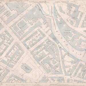
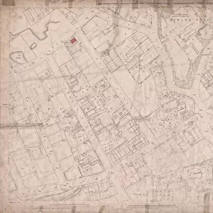
Framed Print : Ordnance Survey Map, Neepsend area of Sheffield, 1889 (Yorkshire sheet number 294. 3. 25)
")


")


![]()
Framed Photos from Sheffield City Archives
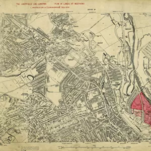
Ordnance Survey Map, Neepsend area of Sheffield, 1889 (Yorkshire sheet number 294. 3. 25)
Surveyed 1889. Reprinted 1891
This map features:
Top left: Neepsend Gas Works, Hallamshire Works [Hallamshire Steel and File Company], Bardwell Street, Manchester, Sheffield and Lincolnshire Railway, Neepsend Lane, Neepsend Tavern, Cook Street, Boyland Place, Boyland Street, Engine Shed, River Don, Gasometer (x2), Prince of Wales Public House.
Top right: Manchester, Sheffield and Lincolnshire Railway, Boyland Street, Engine Shed, Rutland Road, Corporation Yard, Neepsend Brick Works, Rutland Street, Stone Yard.
Bottom left: River Don, Neepsend Lane, Rutland Road, Cannon Brewery, Burton Road, Philadelphia Steel Works [possibly William and Samuel Butcher], Bacon Island, Rutland Works [Samuel Osborn and Co. Limited], Neepsend Bridge, School [Neepsend National School], Playground, Corn Inn, Artisan works, Rutland Hotel Public House, Timber Yard.
Bottom right: Manchester, Sheffield and Lincolnshire Railway, Rutland Road, Cannon Brewery, Burton Road, Rutland Terrace, Hicks Street, Bury Street, Burton Road Brewery [Strouts Brewery Co.], Haddon Street, Percy Street, Rutland Square, Bingley Street, Vicarage [St Michaels and All Angels, Neepsend], Smithy, Corporation Yard, Timber Yard, Platt Street, Timber Yard.
Dimensions of original: 77 x 102 cm.
Scale 10.56 feet : 1 mile [1:500].
From an original at Sheffield Libraries: q00037 (sheet number 294.3.25)
Sheffield City Archives and Local Studies Library has an unrivalled collection of images of Sheffield, England
Media ID 24104149
© Sheffield City Council - All Rights Reserved
14"x12" (38x32cm) Modern Frame
Step back in time with our vintage Ordnance Survey Framed Print from Media Storehouse. This beautifully preserved map of Neepsend area in Sheffield, dated 1889, showcases the historical landscape of the time. Detailed features include Neepsend Gas Works, Hallamshire Works (Hallamshire Steel and File Company), and Bardwell Street, as well as the Manchester, Sheffield and Lincolnshire Railway. Reprinted in 1891 from the original survey, this unique piece is a must-have for history enthusiasts and locals, adding character and charm to any room.
Wood effect frame, card mounted, 10x8 archival quality photo print. Overall outside dimensions 14x12 inches (38x32cm). Environmentally and ozone friendly, 40mm wide x 15mm Polycore® moulding has the look of real wood, is durable and light and easy to hang. Biodegradable and made with non-chlorinated gases (no toxic fumes) it is efficient; producing 100 tons of polystyrene can save 300 tons of trees! Prints are glazed with lightweight, shatterproof, optical clarity acrylic (providing the same general protection from the environment as glass). The back is stapled hardboard with a sawtooth hanger attached. Note: To minimise original artwork cropping, for optimum layout, and to ensure print is secure, the visible print may be marginally smaller
Contemporary Framed and Mounted Prints - Professionally Made and Ready to Hang
Estimated Image Size (if not cropped) is 24.4cm x 17cm (9.6" x 6.7")
Estimated Product Size is 37.6cm x 32.5cm (14.8" x 12.8")
These are individually made so all sizes are approximate
Artwork printed orientated as per the preview above, with landscape (horizontal) orientation to match the source image.
EDITORS COMMENTS
This print showcases an Ordnance Survey Map of the Neepsend area in Sheffield, dating back to 1889. The map, with a Yorkshire sheet number of 294.3.25, was surveyed and reprinted in 1889 and 1891 respectively. The map provides a detailed glimpse into the historical landscape of Neepsend during that period. In the top left corner, notable landmarks such as the Neepsend Gas Works, Hallamshire Works (Hallamshire Steel and File Company), Bardwell Street, Manchester Sheffield and Lincolnshire Railway can be observed. Other features include Neepsend Lane, Neepsend Tavern, Cook Street, Boyland Place, Boyland Street, Engine Shed, River Don along with two gasometers and Prince of Wales Public House. Moving to the top right section of the map reveals additional points of interest like Rutland Road Corporation Yard and Engine Shed alongside Manchester Sheffield and Lincolnshire Railway tracks. The presence of Neepsend Brick Works and Stone Yard further adds to this industrial landscape. In the bottom left corner lies River Don flowing through Cannon Brewery area towards Bacon Island where Philadelphia Steel Works (possibly William and Samuel Butcher) operated. Notable establishments like Rutland Works (Samuel Osborn & Co. ), Corn Inn Pub, Artisan works are also marked on this part of the map. Lastly in the bottom right section we find Burton Road Brewery (Strouts Brewery Co. ), Bingley Street leading up to St Michaels & All Angels Vicarage along with various timber yards nearby. With dimensions measuring at 77 x 102 cm. , this impressive piece offers a scale ratio of 10.56 feet : 1 mile [1:500]. It is sourced from an original document held by Sheffield Libraries under reference q00037 (sheet number 294.3.25).
MADE IN THE UK
Safe Shipping with 30 Day Money Back Guarantee
FREE PERSONALISATION*
We are proud to offer a range of customisation features including Personalised Captions, Color Filters and Picture Zoom Tools
SECURE PAYMENTS
We happily accept a wide range of payment options so you can pay for the things you need in the way that is most convenient for you
* Options may vary by product and licensing agreement. Zoomed Pictures can be adjusted in the Basket.