Framed Print > Animals > Mammals > Muridae > Western Mediterranean Mouse
Framed Print : Map of Western Europe, 1590


![]()
Framed Photos from Science Photo Library
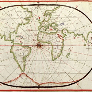
Map of Western Europe, 1590
16th century map of Western Europe. Published around 1590, this map shows the coasts of Western Europe and the Mediterranean, and forms part of a portolan atlas (a collection of navigational charts) by the cartographer Joan Oliva, who was active from 1580-1615. Several compass roses and artworks of sailing ships adorn the oceans, while the coasts are heavily annotated with the names of rivers, ports and bays. The lines on the map are rhumb lines, designed to make it easier to steer a straight course. Although the shape of the British Isles and the Scandinavian coastlines is distorted, maps like this were among the best available at the time
Science Photo Library features Science and Medical images including photos and illustrations
Media ID 1699827
© LIBRARY OF CONGRESS, GEOGRAPHY AND MAP DIVISION/SCIENCE PHOTO LIBRARY
1500s 16th Century Age Of Discovery Cartography Charts Coast Exploration Land Maritime Medieval Mediterranean Middle Ages Western 1590 Portolan
14"x12" (38x32cm) Modern Frame
Discover the rich history of Western Europe with our exquisite Framed Prints from Media Storehouse. This captivating map, published around 1590, takes you back in time to an era of exploration and discovery. Witness the intricate details of the coastlines of Western Europe and the Mediterranean, as depicted in the intriguing "Map of Western Europe, 1590" by Science Photo Library. Each print is meticulously framed to preserve the authenticity of the image, making it a stunning addition to your home or office. Travel back in time and ignite your curiosity with our Framed Prints collection.
Wood effect frame, card mounted, 10x8 archival quality photo print. Overall outside dimensions 14x12 inches (38x32cm). Environmentally and ozone friendly, 40mm wide x 15mm Polycore® moulding has the look of real wood, is durable and light and easy to hang. Biodegradable and made with non-chlorinated gases (no toxic fumes) it is efficient; producing 100 tons of polystyrene can save 300 tons of trees! Prints are glazed with lightweight, shatterproof, optical clarity acrylic (providing the same general protection from the environment as glass). The back is stapled hardboard with a sawtooth hanger attached. Note: To minimise original artwork cropping, for optimum layout, and to ensure print is secure, the visible print may be marginally smaller
Contemporary Framed and Mounted Prints - Professionally Made and Ready to Hang
Estimated Image Size (if not cropped) is 17.2cm x 24.4cm (6.8" x 9.6")
Estimated Product Size is 32.5cm x 37.6cm (12.8" x 14.8")
These are individually made so all sizes are approximate
Artwork printed orientated as per the preview above, with portrait (vertical) orientation to match the source image.
FEATURES IN THESE COLLECTIONS
> Animals
> Mammals
> Muridae
> Western Mediterranean Mouse
> Animals
> Mammals
> Muridae
> Western Mouse
> Arts
> Art Movements
> Medieval Art
> Arts
> Artists
> O
> Oceanic Oceanic
> Arts
> Landscape paintings
> Waterfall and river artworks
> River artworks
> Europe
> France
> Canton
> Landes
> Europe
> United Kingdom
> Scotland
> Western Isles
> Related Images
> Maps and Charts
> Early Maps
> Maps and Charts
> Related Images
> Science Photo Library
> History
EDITORS COMMENTS
This 16th-century map of Western Europe, dating back to 1590, offers a fascinating glimpse into the geographical knowledge and navigational techniques of the time. Created by the skilled cartographer Joan Oliva, this map forms part of a larger portolan atlas that aided sailors in their maritime journeys during the Age of Discovery. The intricately detailed print showcases the coastlines of Western Europe and the Mediterranean Sea, adorned with stunning compass roses and depictions of sailing ships. The meticulous annotations along the coasts provide valuable information on rivers, ports, and bays for seafarers to navigate these treacherous waters. While some distortions are evident in depicting regions like the British Isles and Scandinavian coastlines, it is important to remember that maps like these were considered cutting-edge during this era. The rhumb lines crisscrossing the map served as guides for sailors to maintain a straight course amidst vast expanses of ocean. As we explore this historical artifact further, we gain insight into both medieval European geography and maritime exploration. This remarkable piece exemplifies how cartography played an essential role in expanding our understanding of distant lands during an age marked by curiosity and discovery. Science Photo Library presents us with yet another invaluable window into history through this extraordinary print – reminding us how far we have come while honoring those who paved our way through their dedication to charting unknown territories.
MADE IN THE UK
Safe Shipping with 30 Day Money Back Guarantee
FREE PERSONALISATION*
We are proud to offer a range of customisation features including Personalised Captions, Color Filters and Picture Zoom Tools
SECURE PAYMENTS
We happily accept a wide range of payment options so you can pay for the things you need in the way that is most convenient for you
* Options may vary by product and licensing agreement. Zoomed Pictures can be adjusted in the Basket.