Framed Print > Europe > United Kingdom > Scotland > Highlands > Cromarty
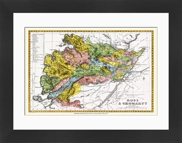
Framed Print : Old County Map of Ross and Cromarty Scotland 1847 by A&C Black


![]()
Framed Photos from MapSeeker
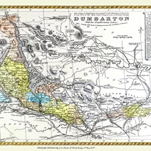
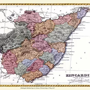
Old County Map of Ross and Cromarty Scotland 1847 by A&C Black
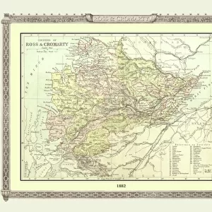
A finely detailed facimile remastered in full colour from an antique original map of Ross and Cromarty featured in A&C Blacks Atlas of 1847. Each Parish is numbered using an index table, colour rendition beautifully differentiating all of the Parishes. As well as principal roads, towns, villages and hamlets, these county maps of Scotland feature key battle sites marked with two crossed swords and the date of the battle
Welcome to the Mapseeker Image library and enter an historic gateway to one of the largest on-line collections of Historic Maps, Nostalgic Views, Vista's and Panorama's from a World gone by.
Media ID 20347576
© Mapseeker Publishing Ltd
A And C Black A And C Black Atlas A And C Black Map County Map County Map Of Scotland Historic Map Old County Map Old Scottish County Map Scottish County Map Cromarty Ross Ross And Cromarty Ross Shire
22"x18" (58x48cm) Modern Frame
Discover the rich history of Ross and Cromarty, Scotland with our exquisite Old County Map of Ross and Cromarty from A&C Black. This stunning Framed Print is a finely detailed facsimile, remastered in full colour from an antique original map featured in A&C Black's Atlas of 1847. The intricate cartography showcases the region's historical boundaries, towns, and topography. Bring a piece of Scotland's past into your home or office with this beautifully preserved and framed map, a perfect addition to any decor or collection. Experience the charm of history with every detail.
Wood effect frame, card mounted, 16x12 archival quality photo print. Overall outside dimensions 22x18 inches (58x48cm). Environmentally and ozone friendly, 40mm wide x 15mm Polycore® moulding has the look of real wood, is durable and light and easy to hang. Biodegradable and made with non-chlorinated gases (no toxic fumes) it is efficient; producing 100 tons of polystyrene can save 300 tons of trees! Prints are glazed with lightweight, shatterproof, optical clarity acrylic (providing the same general protection from the environment as glass). The back is stapled hardboard with a sawtooth hanger attached. Note: To minimise original artwork cropping, for optimum layout, and to ensure print is secure, the visible print may be marginally smaller
Contemporary Framed and Mounted Prints - Professionally Made and Ready to Hang
Estimated Image Size (if not cropped) is 39.6cm x 26.4cm (15.6" x 10.4")
Estimated Product Size is 57.9cm x 47.8cm (22.8" x 18.8")
These are individually made so all sizes are approximate
Artwork printed orientated as per the preview above, with landscape (horizontal) orientation to match the source image.
FEATURES IN THESE COLLECTIONS
> Arts
> Photorealistic artworks
> Detailed art pieces
> Masterful detailing in art
> Europe
> United Kingdom
> Scotland
> Cromartyshire
> Europe
> United Kingdom
> Scotland
> Highlands
> Cromarty
> Europe
> United Kingdom
> Scotland
> Maps
> Europe
> United Kingdom
> Scotland
> Posters
> Europe
> United Kingdom
> Scotland
> Related Images
> Europe
> United Kingdom
> Scotland
> Ross-shire
> Maps and Charts
> Early Maps
> Maps and Charts
> Related Images
> MapSeeker
> Maps from the British Isles
> England and Counties PORTFOLIO
> MapSeeker
> Maps from the British Isles
> Scotland and Counties PORTFOLIO
EDITORS COMMENTS
This beautifully crafted print showcases an exquisite "Old County Map of Ross and Cromarty, Scotland" dating back to 1847. Remastered in full color from an antique original map featured in A&C Black's Atlas, this fine reproduction captures the intricate details that make it a true historical treasure. The map is not only visually stunning but also highly informative. Each Parish is numbered using an index table, allowing for easy navigation and exploration of the region. The expertly applied colors elegantly differentiate all of the Parishes, adding depth and vibrancy to the overall composition. In addition to highlighting principal roads, towns, villages, and hamlets, this county map goes above and beyond by featuring key battle sites marked with two crossed swords alongside their respective dates. This inclusion adds a fascinating layer of historical context to the already captivating piece. Whether you have a personal connection to Ross and Cromarty or simply appreciate Scottish history, this old county map offers a window into the past like no other. Its depiction of Ross shire and Cromartyshire provides valuable insights into these regions' rich heritage. A testament to A&C Black's expertise in cartography during that era, this historic map serves as both a decorative piece for your home or office space as well as an educational tool for those passionate about Scotland's past. Immerse yourself in its intricacies and let your imagination wander through time on this remarkable journey through Ross and Cromarty's history.
MADE IN THE UK
Safe Shipping with 30 Day Money Back Guarantee
FREE PERSONALISATION*
We are proud to offer a range of customisation features including Personalised Captions, Color Filters and Picture Zoom Tools
SECURE PAYMENTS
We happily accept a wide range of payment options so you can pay for the things you need in the way that is most convenient for you
* Options may vary by product and licensing agreement. Zoomed Pictures can be adjusted in the Basket.