Framed Print > Animals > Fishes > R > Roach
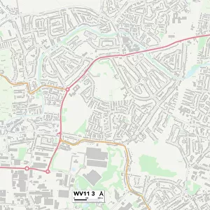
Framed Print : Wolverhampton WV11 2 Map


![]()
Framed Photos from Map Marketing
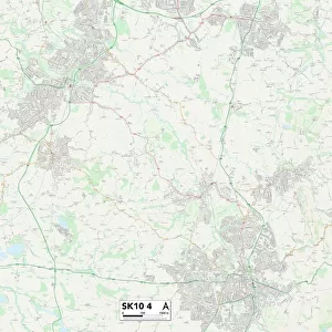
Wolverhampton WV11 2 Map
Postcode Sector Map of Wolverhampton WV11 2
Media ID 19983370
Acorn Road Ashmore Avenue Aspen Road Barnard Road Birch Road Birchwood Close Blackthorn Court Bloomfield Drive Brindley Avenue Broad Lane Buttermere Drive Charles Avenue Clare Avenue Cleveland Close Coppice Close Danes Close Downing Close Drummond Close Elmwood Avenue Exton Close Ferguson Street Ferndale Road Gilbert Close Gorse Road Hawthorne Road Hill Place Hill Street Hilton Lane Howard Road Kingsway Long Lane Meadow View Millbank Street Mitre Close New Street Oakwood Close Palmer Close Park Close Park Way Parker Road Parry Road Peacock Avenue Radstock Road Red Lane Rogers Close Rosemary Court Rosewood Gardens Rowan Drive Russell Close Springhill St Albans Close St Johns Road Stanley Close Stephens Close The Gables Thirlmere Drive Thornley Close Thornley Road Tudor Court Vernon Close Vernon Way Whitehouse Crescent Willow Grove Wolverhampton Wolverhampton Road Essington High Hill
14"x12" (38x32cm) Modern Frame
Wood effect frame, card mounted, 10x8 archival quality photo print. Overall outside dimensions 14x12 inches (38x32cm). Environmentally and ozone friendly, 40mm wide x 15mm Polycore® moulding has the look of real wood, is durable and light and easy to hang. Biodegradable and made with non-chlorinated gases (no toxic fumes) it is efficient; producing 100 tons of polystyrene can save 300 tons of trees! Prints are glazed with lightweight, shatterproof, optical clarity acrylic (providing the same general protection from the environment as glass). The back is stapled hardboard with a sawtooth hanger attached. Note: To minimise original artwork cropping, for optimum layout, and to ensure print is secure, the visible print may be marginally smaller
Contemporary Framed and Mounted Prints - Professionally Made and Ready to Hang
Estimated Image Size (if not cropped) is 24.4cm x 17.3cm (9.6" x 6.8")
Estimated Product Size is 37.6cm x 32.5cm (14.8" x 12.8")
These are individually made so all sizes are approximate
Artwork printed orientated as per the preview above, with landscape (horizontal) orientation to match the source image.
FEATURES IN THESE COLLECTIONS
> Animals
> Fishes
> R
> Roach
> Arts
> Artists
> B
> John Barnard
> Arts
> Artists
> D
> John Drummond
> Arts
> Artists
> G
> John Gilbert
> Arts
> Artists
> H
> John Hillers
> Arts
> Artists
> H
> John Hills
> Arts
> Artists
> P
> Charles Phillips
> Arts
> Artists
> P
> John Parker
> Arts
> Artists
> P
> John Phillip
> Arts
> Artists
> R
> Charles Russell
> Map Marketing
> Postcode Sector Maps
> WV - Wolverhampton
MADE IN THE UK
Safe Shipping with 30 Day Money Back Guarantee
FREE PERSONALISATION*
We are proud to offer a range of customisation features including Personalised Captions, Color Filters and Picture Zoom Tools
SECURE PAYMENTS
We happily accept a wide range of payment options so you can pay for the things you need in the way that is most convenient for you
* Options may vary by product and licensing agreement. Zoomed Pictures can be adjusted in the Basket.