Framed Print > Europe > France > Canton > Nord
Framed Print : Cyrenaique; Le Nord-Est Africain, 1914. Creator: Unknown


![]()
Framed Photos from Heritage Images
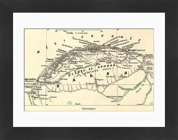
Cyrenaique; Le Nord-Est Africain, 1914. Creator: Unknown
Cyrenaique; Le Nord-Est Africain, 1914. From "Grande Geographie Bong Illustree", 1914
Heritage Images features heritage image collections
Media ID 36296389
© The Print Collector/Heritage Images
Cartography Libya Map Making Mapmaking
22"x18" (58x48cm) Modern Frame
Discover the captivating allure of the past with our Media Storehouse Framed Print of "Cyrenaique; Le Nord-Est Africain," a striking image from 1914. Originally published in Grande Geographie Bong Illustree, this vintage photograph transports you back in time, showcasing the enigmatic beauty of a North-Eastern African woman. The unknown creator's masterful use of light and shadow adds depth and intrigue to this timeless piece. Each Framed Print is meticulously crafted with museum-quality materials, ensuring a lasting impression that adds character and charm to any room. Bring a piece of history into your home and elevate your decor with this exquisite, unknown masterpiece from our Media Storehouse collection.
Wood effect frame, card mounted, 16x12 archival quality photo print. Overall outside dimensions 22x18 inches (58x48cm). Environmentally and ozone friendly, 40mm wide x 15mm Polycore® moulding has the look of real wood, is durable and light and easy to hang. Biodegradable and made with non-chlorinated gases (no toxic fumes) it is efficient; producing 100 tons of polystyrene can save 300 tons of trees! Prints are glazed with lightweight, shatterproof, optical clarity acrylic (providing the same general protection from the environment as glass). The back is stapled hardboard with a sawtooth hanger attached. Note: To minimise original artwork cropping, for optimum layout, and to ensure print is secure, the visible print may be marginally smaller
Contemporary Framed and Mounted Prints - Professionally Made and Ready to Hang
Estimated Image Size (if not cropped) is 39.6cm x 25.2cm (15.6" x 9.9")
Estimated Product Size is 57.9cm x 47.8cm (22.8" x 18.8")
These are individually made so all sizes are approximate
Artwork printed orientated as per the preview above, with landscape (horizontal) orientation to match the source image.
FEATURES IN THESE COLLECTIONS
> Africa
> Libya
> Related Images
> Europe
> France
> Canton
> Nord
> Maps and Charts
> Related Images
Cyrenaique; Le Nord-Est Africain,
EDITORS COMMENTS
a captivating and intricately detailed map print from the early 20th century, offers a glimpse into the fascinating world of colonial cartography. The map, created in 1914, is a testament to the exploratory spirit and geographical knowledge of the time, with a focus on the Nord-Est Africain, or Northeastern Africa, primarily encompassing present-day Libya. The map's title, "Cyrenaique," is a reference to Cyrenaica, an ancient region in Libya, known for its rich history and natural resources. The map's vibrant colors and meticulous attention to detail showcase the vast expanses of the African continent, with borders delineating various countries and territories under French control. The map's creation can be traced back to the period of intense French colonial expansion in Africa, with Libya becoming a French protectorate in 1912. The map's production is attributed to the unknown cartographers of "Grande Geographie Bong Illustree," a renowned French geography publication. The map's intricacies reveal the level of detail and accuracy that cartographers were able to achieve during this era. The print's rich colors and bold lines highlight various geographical features, including mountains, rivers, and bodies of water. The map also includes annotations and labels, providing valuable information about the region's topography, climate, and population. As a collector or historian, this map print offers a unique perspective on the geographical knowledge and colonial ambitions of the early 20th century. Its intricate details and historical significance make it a valuable addition to any collection focused on African history, cartography, or geography. The map's enduring allure continues to captivate and inspire, offering a glimpse into a bygone era of exploration and discovery.
MADE IN THE UK
Safe Shipping with 30 Day Money Back Guarantee
FREE PERSONALISATION*
We are proud to offer a range of customisation features including Personalised Captions, Color Filters and Picture Zoom Tools
SECURE PAYMENTS
We happily accept a wide range of payment options so you can pay for the things you need in the way that is most convenient for you
* Options may vary by product and licensing agreement. Zoomed Pictures can be adjusted in the Basket.