Framed Print > Granger Art on Demand > Maps
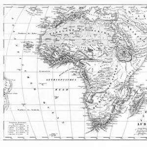
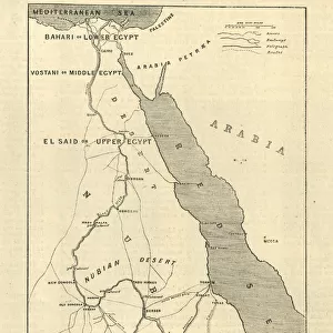
Framed Print : AFRICA: MAP, 1894. Race Chart No. 8, Showing the Geographical Distribution of


![]()
Framed Photos from Granger
AFRICA: MAP, 1894. Race Chart No. 8, Showing the Geographical Distribution of
AFRICA: MAP, 1894.
Race Chart No. 8, Showing the Geographical Distribution of the African Nigritians. Engraving, 1894
Granger holds millions of images spanning more than 25,000 years of world history, from before the Stone Age to the dawn of the Space Age
Media ID 12321279
1894 Africa African Chart Distribution Race Sudan Sudanese
14"x12" (38x32cm) Modern Frame
Discover the captivating history of Africa with our Framed Prints from Media Storehouse, featuring the rare and thought-provoking "AFRICA: MAP, 1894. Race Chart No. 8, Showing the Geographical Distribution of the African Nigritians" from The Granger Collection. This vintage engraving, originally published in 1894, offers a unique perspective into the historical understanding of African populations during that time. Each print comes expertly framed, adding an air of sophistication and intrigue to any space. Transport yourself on a journey through time and immerse yourself in the rich tapestry of African history.
Wood effect frame, card mounted, 10x8 archival quality photo print. Overall outside dimensions 14x12 inches (38x32cm). Environmentally and ozone friendly, 40mm wide x 15mm Polycore® moulding has the look of real wood, is durable and light and easy to hang. Biodegradable and made with non-chlorinated gases (no toxic fumes) it is efficient; producing 100 tons of polystyrene can save 300 tons of trees! Prints are glazed with lightweight, shatterproof, optical clarity acrylic (providing the same general protection from the environment as glass). The back is stapled hardboard with a sawtooth hanger attached. Note: To minimise original artwork cropping, for optimum layout, and to ensure print is secure, the visible print may be marginally smaller
Contemporary Framed and Mounted Prints - Professionally Made and Ready to Hang
Estimated Image Size (if not cropped) is 17.1cm x 24.4cm (6.7" x 9.6")
Estimated Product Size is 32.5cm x 37.6cm (12.8" x 14.8")
These are individually made so all sizes are approximate
Artwork printed orientated as per the preview above, with portrait (vertical) orientation to match the source image.
EDITORS COMMENTS
This print titled "AFRICA: MAP, 1894. Race Chart No. 8, Showing the Geographical Distribution of the African Nigritians" takes us back in time to the late 19th century when exploration and discovery were at their peak. The intricate engraving showcases a detailed map of Africa, highlighting the geographical distribution of the African Nigritians. As we gaze upon this historical artifact, we are transported to an era where knowledge about different races and cultures was still being unraveled. The race chart provides valuable insights into the diverse ethnic groups that inhabited Sudan and other regions across Africa during that period. The fine craftsmanship of this engraving is evident in its meticulous details and delicate lines. It serves as a testament to both artistic skill and scientific curiosity prevalent during those times. Through this image, we can appreciate how far our understanding of Africa's cultural tapestry has evolved over time while acknowledging that there is always more to learn about our shared human history. Granger Art on Demand brings us yet another remarkable piece from their Carousel Collection with this thought-provoking print. As we reflect on it, let us embrace diversity and celebrate the richness of African heritage while striving for greater inclusivity in today's world.
MADE IN THE UK
Safe Shipping with 30 Day Money Back Guarantee
FREE PERSONALISATION*
We are proud to offer a range of customisation features including Personalised Captions, Color Filters and Picture Zoom Tools
SECURE PAYMENTS
We happily accept a wide range of payment options so you can pay for the things you need in the way that is most convenient for you
* Options may vary by product and licensing agreement. Zoomed Pictures can be adjusted in the Basket.