Framed Print > Animals > Mammals > Cats (Domestic) > Russian White
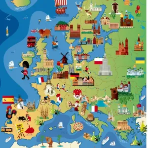
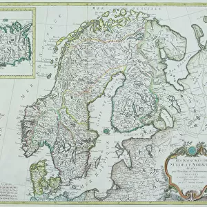
Framed Print : Map of Europe with illustrations of famous landmarks and items associated with various countries


![]()
Framed Photos from Fine Art Storehouse
Map of Europe with illustrations of famous landmarks and items associated with various countries
Unleash your creativity and transform your space into a visual masterpiece!
Dorling Kindersley
Media ID 13558379
© This content is subject to copyright
British Isles Countries Earth Finnish Lapland Former Soviet Union French Culture Geographical Locations Geography German Culture Great Britain Illustrations Irish Republic Italian Culture Landmarks Lapland Large Group Of Objects Russia Russian Culture Scandinavia Shoreline Tourist Attractions Ussr World
30"x26" (78x68cm) Modern Frame
Discover the rich cultural heritage of Europe with our exquisite Framed Print by Dorling Kindersley from the Media Storehouse Fine Art collection. This stunning representation of Europe showcases intricately detailed illustrations of famous landmarks and iconic items unique to each country. Bring the history and beauty of Europe right into your home or office with this captivating work of art. The high-quality print is expertly framed to preserve its vibrant colors and intricate details, making it a perfect addition to any space. Experience the essence of Europe like never before with our Framed Print by Dorling Kindersley.
Wood effect frame, card mounted, 24x20 archival quality photo print. Overall outside dimensions 30x26 inches (76x68cm). Environmentally and ozone friendly, 43mm wide x 32mm Polycore® moulding has the look of real wood, is durable and light and easy to hang. Biodegradable and made with non-chlorinated gases (no toxic fumes) it is efficient; producing 100 tons of polystyrene can save 300 tons of trees! Prints are glazed with lightweight, shatterproof, optical clarity acrylic (providing the same general protection from the environment as glass). The back is stapled hardboard with a sawtooth hanger attached. Note: To minimise original artwork cropping, for optimum layout, and to ensure print is secure, the visible print may be marginally smaller
Contemporary Framed and Mounted Prints - Professionally Made and Ready to Hang
Estimated Image Size (if not cropped) is 59.9cm x 54.9cm (23.6" x 21.6")
Estimated Product Size is 78.2cm x 68.2cm (30.8" x 26.9")
These are individually made so all sizes are approximate
Artwork printed orientated as per the preview above, with landscape (horizontal) orientation to match the source image.
FEATURES IN THESE COLLECTIONS
> Fine Art Storehouse
> Map
> Italian Maps
> Fine Art Storehouse
> Photo Libraries
> Dorling Kindersley Prints
> Animals
> Fishes
> G
> Grouper
> Animals
> Mammals
> Cats (Domestic)
> Russian White
> Arts
> Artists
> O
> Oceanic Oceanic
> Europe
> Finland
> Related Images
> Europe
> Germany
> Related Images
EDITORS COMMENTS
This print by Dorling Kindersley showcases a vibrant and detailed "Map of Europe with illustrations of famous landmarks and items associated with various countries". Bursting with color, this image transports us to the diverse landscapes and rich cultures that make up the European continent. From the British Isles to Scandinavia, this horizontal map takes us on an enchanting journey through geographical locations that have shaped history. The white background allows each illustration to stand out, capturing our attention as we explore every corner of this magnificent map. Famous landmarks such as the Eiffel Tower in France, the Colosseum in Italy, and Germany's Brandenburg Gate are beautifully depicted alongside iconic symbols representing Russian culture or German traditions. This large group of objects represents not only physical geography but also serves as a visual celebration of European heritage. As we follow the coastline along Spain's shores or venture into Lapland's snowy landscapes, it becomes clear that this map is more than just a tool for navigation; it is an invitation to travel destinations filled with wonder and awe-inspiring beauty. Whether you're planning your next adventure or simply appreciate artistry combined with educational value, this Map of Europe print will undoubtedly captivate your imagination. Let it transport you across borders and immerse yourself in the richness and diversity that Europe has to offer.
MADE IN THE UK
Safe Shipping with 30 Day Money Back Guarantee
FREE PERSONALISATION*
We are proud to offer a range of customisation features including Personalised Captions, Color Filters and Picture Zoom Tools
SECURE PAYMENTS
We happily accept a wide range of payment options so you can pay for the things you need in the way that is most convenient for you
* Options may vary by product and licensing agreement. Zoomed Pictures can be adjusted in the Basket.