Framed Print > Asia > Turkey > Related Images
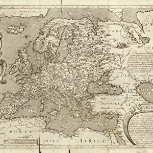
Framed Print : Antique Map of Europe, 1785


![]()
Framed Photos from Fine Art Storehouse
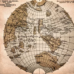
Antique Map of Europe, 1785
An accurate map of Europe from the best authorities. London: C. Dilly & G. Robinson: 1785. Original size: 35.7 x 37.4 cm. Coloured, Inset: Spitsbergen, East and West Greenland, and Iceland. Engraved for William Guthrie
Unleash your creativity and transform your space into a visual masterpiece!
BernardAllum
Media ID 13597639
© Bernard Allum
Backgrounds Baltic Countries Black Sea Continent Denmark Direction Document European Culture Finland Grunge Grunge Image Technique Hungary Latitude Longitude Manuscript Ornate Paper Past Pattern Sepia Toned Social History Square Stained Textured Effect Topography Torn Travel Backgrounds Travel Locations Turkey Turkey Middle East Vector World Map Common Market
14"x12" (38x32cm) Modern Frame
Step back in time with our exquisite Antique Map of Europe, 1785 from the Media Storehouse Fine Art collection. This beautifully preserved print, published by C. Dilly & G. Robinson in London, showcases an intricately detailed representation of Europe as it was known over 200 years ago. Richly coloured and meticulously crafted, this antique map boasts an inset of Spitsbergen, East and West Greenland, and Iceland, adding to its historical significance. Bring the old-world charm into your home or office, and transport yourself on a journey through history with this stunning piece from the Fine Art Storehouse.
Wood effect frame, card mounted, 10x8 archival quality photo print. Overall outside dimensions 14x12 inches (38x32cm). Environmentally and ozone friendly, 40mm wide x 15mm Polycore® moulding has the look of real wood, is durable and light and easy to hang. Biodegradable and made with non-chlorinated gases (no toxic fumes) it is efficient; producing 100 tons of polystyrene can save 300 tons of trees! Prints are glazed with lightweight, shatterproof, optical clarity acrylic (providing the same general protection from the environment as glass). The back is stapled hardboard with a sawtooth hanger attached. Note: To minimise original artwork cropping, for optimum layout, and to ensure print is secure, the visible print may be marginally smaller
Contemporary Framed and Mounted Prints - Professionally Made and Ready to Hang
Estimated Image Size (if not cropped) is 24.4cm x 21.3cm (9.6" x 8.4")
Estimated Product Size is 37.6cm x 32.5cm (14.8" x 12.8")
These are individually made so all sizes are approximate
Artwork printed orientated as per the preview above, with landscape (horizontal) orientation to match the source image.
FEATURES IN THESE COLLECTIONS
> Fine Art Storehouse
> Map
> Denmark Maps
> Fine Art Storehouse
> Map
> Historical Maps
> Fine Art Storehouse
> Map
> Italian Maps
> Asia
> Turkey
> Related Images
> Europe
> Denmark
> Paintings
> Europe
> Denmark
> Related Images
> Europe
> Finland
> Paintings
> Europe
> Finland
> Related Images
EDITORS COMMENTS
This antique map of Europe, dating back to 1785, offers a fascinating glimpse into the continent's rich history and cultural heritage. Created by esteemed cartographers C. Dilly & G. Robinson in London, this meticulously crafted print showcases the intricate topography and geographical accuracy of its time. Measuring at an original size of 35.7 x 37.4 cm, this beautifully colored map features an ornate design with delicate illustrations and painting techniques that add depth and character to its appearance. The inclusion of insets highlighting Spitsbergen, East and West Greenland, as well as Iceland further enhances its informational value. With its sepia-toned textured effect and subtle stains from years gone by, this vintage piece exudes a sense of nostalgia that transports us back to a different era. Its torn edges remind us of the passage of time while adding an authentic touch to the overall composition. As we explore this historical document, we are taken on a journey across Europe's diverse landscape - from Turkey to Hungary, Baltic countries to Spain, Italy to Germany - each country marked with precision along with significant bodies of water such as the Black Sea. This remarkable map serves not only as a testament to scientific advancements in cartography but also provides valuable insights into past societies and their understanding of geography. A true treasure for enthusiasts interested in European culture or those seeking inspiration from centuries-old craftsmanship.
MADE IN THE UK
Safe Shipping with 30 Day Money Back Guarantee
FREE PERSONALISATION*
We are proud to offer a range of customisation features including Personalised Captions, Color Filters and Picture Zoom Tools
SECURE PAYMENTS
We happily accept a wide range of payment options so you can pay for the things you need in the way that is most convenient for you
* Options may vary by product and licensing agreement. Zoomed Pictures can be adjusted in the Basket.