Framed Print > North America > Cuba > Cuba Heritage Sites > Old Havana and its Fortification System
Framed Print : Geography Atlas: representation of the Caribbean Sea region, the Caribbean (Cuba, Jamaica, Hispaniola, Jamaica), the Bahamas Islands, the Lesser Antilles, the northern coasts of South America and the southern coasts of the United States
, the Bahamas Islands, the Lesser Antilles, the northern coasts of South America and the southern coasts of the United States")


, the Bahamas Islands, the Lesser Antilles, the northern coasts of South America and the southern coasts of the United States")


![]()
Framed Photos From Fine Art Finder
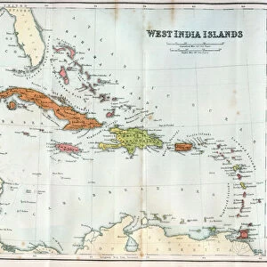
Geography Atlas: representation of the Caribbean Sea region, the Caribbean (Cuba, Jamaica, Hispaniola, Jamaica), the Bahamas Islands, the Lesser Antilles, the northern coasts of South America and the southern coasts of the United States
VEN5030043 Geography Atlas: representation of the Caribbean Sea region, the Caribbean (Cuba, Jamaica, Hispaniola, Jamaica), the Bahamas Islands, the Lesser Antilles, the northern coasts of South America and the southern coasts of the United States. Map from an Atlas by John Cary (1754-1835), 1803. Biblioteca Jose Marti, Havana, Cuba.; (add.info.: Geography Atlas: representation of the Caribbean Sea region, the Caribbean (Cuba, Jamaica, Hispaniola, Jamaica), the Bahamas Islands, the Lesser Antilles, the northern coasts of South America and the southern coasts of the United States. Map from an Atlas by John Cary (1754-1835), 1803. Biblioteca Jose Marti, Havana, Cuba.); © Marage Photos
Media ID 38478618
© © Marage Photos / Bridgeman Images
Amerique Centrale Amerique Du Nord Caraïbes Caribbean Caribbean Island Carte Geographique Central America Cuba Cuba Cubain Cubaine Cubains Cubaines Cuban Etats Unis Geographie Jamaica Jamaican Stockravenna Geographical Map
14"x12" (38x32cm) Modern Frame
Explore the beauty of the Caribbean Sea region with our framed print featuring a detailed representation from Bridgeman Images. Perfect for adding a touch of tropical charm to any space. ?? #CaribbeanArt #FineArtFinder #MediaStorehouse
Wood effect frame, card mounted, 10x8 archival quality photo print. Overall outside dimensions 14x12 inches (38x32cm). Environmentally and ozone friendly, 40mm wide x 15mm Polycore® moulding has the look of real wood, is durable and light and easy to hang. Biodegradable and made with non-chlorinated gases (no toxic fumes) it is efficient; producing 100 tons of polystyrene can save 300 tons of trees! Prints are glazed with lightweight, shatterproof, optical clarity acrylic (providing the same general protection from the environment as glass). The back is stapled hardboard with a sawtooth hanger attached. Note: To minimise original artwork cropping, for optimum layout, and to ensure print is secure, the visible print may be marginally smaller
Contemporary Framed and Mounted Prints - Professionally Made and Ready to Hang
Estimated Image Size (if not cropped) is 24.4cm x 17.5cm (9.6" x 6.9")
Estimated Product Size is 37.6cm x 32.5cm (14.8" x 12.8")
These are individually made so all sizes are approximate
Artwork printed orientated as per the preview above, with landscape (horizontal) orientation to match the source image.
FEATURES IN THESE COLLECTIONS
> Fine Art Finder
> Artists
> Pasquier (workshop of) Grenier
> Maps and Charts
> Early Maps
> Maps and Charts
> Related Images
> North America
> The Bahamas
> Maps
> North America
> The Bahamas
> Related Images
> North America
> Cuba
> Cuba Heritage Sites
> Old Havana and its Fortification System
> North America
> Cuba
> Havana
> North America
> Cuba
> Maps
> North America
> Cuba
> Related Images
> North America
> Jamaica
> Maps
EDITORS COMMENTS
This stunning print from the Geography Atlas showcases the intricate details of the Caribbean Sea region, including Cuba, Jamaica, Hispaniola, and the Bahamas Islands. Created by John Cary in 1803, this map offers a glimpse into the geographical landscape of the area during that time period.
The representation of the Lesser Antilles and the northern coasts of South America adds to the richness of this historical piece. The southern coasts of the United States are also included in this comprehensive atlas, providing a holistic view of these interconnected regions.
Displayed at Biblioteca Jose Marti in Havana, Cuba, this map serves as a valuable resource for understanding the complex geography and topography of Central America and North America during the 19th century. The detailed engravings capture not only physical features but also cultural nuances that define each location.
As you study this print closely, you can appreciate how it reflects centuries-old cartographic techniques and artistic craftsmanship. Whether you're a history buff or simply intrigued by maps, this Geography Atlas print is sure to captivate your imagination with its wealth of information about these diverse landscapes.
MADE IN THE UK
Safe Shipping with 30 Day Money Back Guarantee
FREE PERSONALISATION*
We are proud to offer a range of customisation features including Personalised Captions, Color Filters and Picture Zoom Tools
SECURE PAYMENTS
We happily accept a wide range of payment options so you can pay for the things you need in the way that is most convenient for you
* Options may vary by product and licensing agreement. Zoomed Pictures can be adjusted in the Basket.