Framed Print > Europe > Italy > Emilia-Romagna > Ravenna
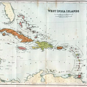
Framed Print : Geography Atlas: representation of the Bahamas islands, northern Hispaniola (Santo Domingo) and the Leewind Passage between Cuba and Hispaniola in the West Indies. Map from an atlas of 1802. Biblioteca Jose Marti, Havana, Cuba
 and the Leewind Passage between Cuba and Hispaniola in the West Indies. Map from an atlas of 1802. Biblioteca Jose Marti, Havana, Cuba")
 and the Leewind Passage between Cuba and Hispaniola in the West Indies. Map from an atlas of 1802. Biblioteca Jose Marti, Havana, Cuba")


![]()
Framed Photos From Fine Art Finder
Geography Atlas: representation of the Bahamas islands, northern Hispaniola (Santo Domingo) and the Leewind Passage between Cuba and Hispaniola in the West Indies. Map from an atlas of 1802. Biblioteca Jose Marti, Havana, Cuba
VEN5031335 Geography Atlas: representation of the Bahamas islands, northern Hispaniola (Santo Domingo) and the Leewind Passage between Cuba and Hispaniola in the West Indies. Map from an atlas of 1802. Biblioteca Jose Marti, Havana, Cuba.; (add.info.: Geography Atlas: representation of the Bahamas islands, northern Hispaniola (Santo Domingo) and the Leewind Passage between Cuba and Hispaniola in the West Indies. Map from an atlas of 1802. Biblioteca Jose Marti, Havana, Cuba.); Photo © Marco Ravenna
Media ID 38484848
© © Marco Ravenna / Bridgeman Images
Amerique Centrale Amerique Du Nord Caraïbes Caribbean Caribbean Island Carte Geographique Central America Dominium Etats Unis Geographie Haiti Saint Domingue Stockravenna Geographical Map
22"x18" (58x48cm) Modern Frame
Explore the beauty of the Caribbean with this stunning framed print showcasing a historical map from 1802. Perfect for adding a touch of vintage charm to any space. ?️? #CaribbeanArt #VintageMap
Wood effect frame, card mounted, 16x12 archival quality photo print. Overall outside dimensions 22x18 inches (58x48cm). Environmentally and ozone friendly, 40mm wide x 15mm Polycore® moulding has the look of real wood, is durable and light and easy to hang. Biodegradable and made with non-chlorinated gases (no toxic fumes) it is efficient; producing 100 tons of polystyrene can save 300 tons of trees! Prints are glazed with lightweight, shatterproof, optical clarity acrylic (providing the same general protection from the environment as glass). The back is stapled hardboard with a sawtooth hanger attached. Note: To minimise original artwork cropping, for optimum layout, and to ensure print is secure, the visible print may be marginally smaller
Contemporary Framed and Mounted Prints - Professionally Made and Ready to Hang
Estimated Image Size (if not cropped) is 39.6cm x 26.4cm (15.6" x 10.4")
Estimated Product Size is 57.9cm x 47.8cm (22.8" x 18.8")
These are individually made so all sizes are approximate
Artwork printed orientated as per the preview above, with landscape (horizontal) orientation to match the source image.
FEATURES IN THESE COLLECTIONS
> Fine Art Finder
> Artists
> Pasquier (workshop of) Grenier
> Europe
> Italy
> Emilia-Romagna
> Ravenna
> Maps and Charts
> Early Maps
> Maps and Charts
> Related Images
> North America
> The Bahamas
> Maps
> North America
> The Bahamas
> Related Images
> North America
> Cuba
> Cuba Heritage Sites
> Old Havana and its Fortification System
> North America
> Cuba
> Havana
> North America
> Cuba
> Maps
> North America
> Cuba
> Related Images
EDITORS COMMENTS
This stunning print captures a piece of history from an atlas of 1802, showcasing the Geography Atlas representation of the Bahamas islands, northern Hispaniola (Santo Domingo), and the Leewind Passage between Cuba and Hispaniola in the West Indies. The intricate details on this map provide a glimpse into the geographical landscape of these Caribbean islands during the 19th century.
Displayed at Biblioteca Jose Marti in Havana, Cuba, this map serves as a valuable historical artifact that offers insight into the early exploration and colonization of Central America. The engraving beautifully illustrates the topography and boundaries of these regions, shedding light on their dominium and significance in shaping American history.
As we gaze upon this image, we are transported back in time to an era when cartographers meticulously charted uncharted territories with precision and dedication. The vibrant colors and intricate lines on this map evoke a sense of wonder and curiosity about our world's past.
Whether you are a history enthusiast or simply appreciate fine art photography, this print by Marco Ravenna is sure to spark your imagination and ignite your passion for exploring different cultures and landscapes. Let it serve as a reminder of how far we have come in understanding our planet's diverse geography while also honoring those who paved the way for future generations to continue learning about our world.
MADE IN THE UK
Safe Shipping with 30 Day Money Back Guarantee
FREE PERSONALISATION*
We are proud to offer a range of customisation features including Personalised Captions, Color Filters and Picture Zoom Tools
SECURE PAYMENTS
We happily accept a wide range of payment options so you can pay for the things you need in the way that is most convenient for you
* Options may vary by product and licensing agreement. Zoomed Pictures can be adjusted in the Basket.