Home > Europe > Montenegro > Maps
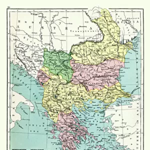
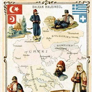
Historical map of the Ottoman Empire (Turkey), European part, 1897
, European part, 1897")
![]()
Wall Art and Photo Gifts from Fine Art Storehouse
Historical map of the Ottoman Empire (Turkey), European part, 1897
Historical map of European part of the Ottoman Empire (Turkey) at the end of the 19th century. Lithograph, published in 1897
Unleash your creativity and transform your space into a visual masterpiece!
ZU_09
Media ID 35843126
Aegean Sea Anatolia Brown Bulgaria Country Geographic Area European Culture Greece Mediterranean Sea Montenegro Ottoman Empire Romania Serbia Topographic Map Topography Turkey Middle East Turkish Culture Multi Colored
FEATURES IN THESE COLLECTIONS
> Asia
> Turkey
> Related Images
> Europe
> Montenegro
> Maps
> Fine Art Storehouse
> Map
> Historical Maps
> Maps and Charts
> Early Maps
> Maps and Charts
> Montenegro
EDITORS COMMENTS
This historical map print showcases the European part of the Ottoman Empire, as it existed at the turn of the 20th century. The intricately detailed lithograph, published in 1897, offers a glimpse into the rich history and cultural tapestry of the Middle East, Anatolia, Europe, and the Mediterranean. The Ottoman Empire, once a powerful and expansive realm, is depicted in this map with its various provinces and territories, including modern-day Turkey, Greece, Serbia, Romania, Montenegro, and Bulgaria. The intricate topography of the region is highlighted through the use of browns and earthy tones, while the bodies of water, such as the Mediterranean and Aegean Seas, are rendered in vibrant blues. The map's horizontal orientation allows for a clear and comprehensive view of the geographic area, with cities, rivers, and mountains all carefully labeled and delineated. The Ottoman Empire's complex history is brought to life through this topographic masterpiece, providing a fascinating window into the past. For history enthusiasts, travelers, and anyone with an appreciation for the cultural and geographic wonders of the world, this historical map print is an essential addition to any collection. Its antique charm, evocative of the 19th century, adds a touch of elegance and sophistication to any room. This map is a beautiful reminder of the rich history and diverse cultures that have shaped the world we live in today. Hang it on your wall and let it transport you to another time and place.
MADE IN THE UK
Safe Shipping with 30 Day Money Back Guarantee
FREE PERSONALISATION*
We are proud to offer a range of customisation features including Personalised Captions, Color Filters and Picture Zoom Tools
SECURE PAYMENTS
We happily accept a wide range of payment options so you can pay for the things you need in the way that is most convenient for you
* Options may vary by product and licensing agreement. Zoomed Pictures can be adjusted in the Basket.