Home > Arts > Artists > P > those present
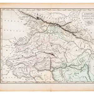
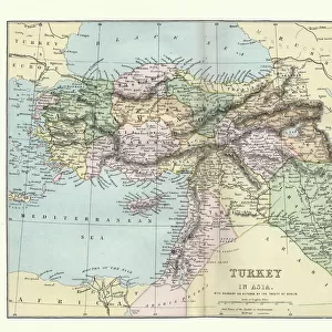
Antique map of Ancient Armenia, Colchis Iberia, Albania, Atlas of Ancient Geography

![]()
Wall Art and Photo Gifts from Fine Art Storehouse
Antique map of Ancient Armenia, Colchis Iberia, Albania, Atlas of Ancient Geography
Vintage illustration of Antique map of Ancient Armenia, Colchis Iberia, Albania, Atlas of Ancient Geography. By Samuel Butler. In Greco-Roman geography, Colchis was an exonym for the Georgian polity of Egrisi located on the coast of the Black Sea, centered in present-day western Georgia
Unleash your creativity and transform your space into a visual masterpiece!
duncan1890
Media ID 25600705
FEATURES IN THESE COLLECTIONS
> Arts
> Artists
> P
> those present
> Fine Art Storehouse
> Map
> Historical Maps
> Maps and Charts
> Early Maps
EDITORS COMMENTS
This stunning vintage print showcases an antique map of Ancient Armenia, Colchis Iberia, and Albania from the Atlas of Ancient Geography. The intricate details and rich colors transport us back in time to a bygone era. Created by Samuel Butler, this Greco-Roman geography masterpiece offers a glimpse into the historical significance of these regions. The focal point of the map is Colchis, which was known as an exonym for the Georgian polity of Egrisi during ancient times. Situated along the captivating coast of the Black Sea, it held great importance in Western Georgia's history. As we admire this print, we can imagine sailors navigating its shores and traders exchanging goods within its bustling markets. Every line on this vintage illustration tells a story - each curve representing rivers that once flowed through these lands and every marking symbolizing cities that thrived with life centuries ago. It serves as a reminder of our interconnectedness with those who came before us and their contributions to shaping our world today. Duncan1890 has skillfully captured this piece from Fine Art Storehouse, preserving its authenticity while allowing us to appreciate its beauty anew. Whether you are an avid historian or simply appreciate artistry at its finest, this antique map print is sure to captivate your imagination and spark curiosity about ancient civilizations that once flourished in Armenia, Colchis Iberia, and Albania.
MADE IN THE UK
Safe Shipping with 30 Day Money Back Guarantee
FREE PERSONALISATION*
We are proud to offer a range of customisation features including Personalised Captions, Color Filters and Picture Zoom Tools
SECURE PAYMENTS
We happily accept a wide range of payment options so you can pay for the things you need in the way that is most convenient for you
* Options may vary by product and licensing agreement. Zoomed Pictures can be adjusted in the Basket.