Fraud Blocker Skip to main content

Home > Europe > Armenia > Maps

Maps Collection

Maps of Armenia Europe are important tools for understanding the geography of the region

Choose a picture from our Maps Collection for your Wall Art and Photo Gifts

76 items

Background imageMaps Collection: Old Caucasus map

Old Caucasus map
Antique map of Caucasus

Background imageMaps Collection: Antique map of the Middle East by Halma

Antique map of the Middle East by Halma

Background imageMaps Collection: Mideast map during the Crusades

Mideast map during the Crusades
Map of the Middle East at the time of the Crusades. Printed color lithograph

Background imageMaps Collection: The Babylonian Map of the World, c. 510-c. 500 BC. Artist: Assyrian Art

The Babylonian Map of the World, c. 510-c. 500 BC. Artist: Assyrian Art
The Babylonian Map of the World, c. 510-c. 500 BC. Found in the collection of British Museum

Background imageMaps Collection: Persian Empire about 500 BC

Persian Empire about 500 BC
Map of the Persian Empire under Darius I, with principal satrapies, about 500 BC. Color lithograph reproduction of a 19th-century illustration

Background imageMaps Collection: Map of the Roman Empire

Map of the Roman Empire
Map showing the extent of the Roman Empire. Hand-colored woodcut of a 19th-century illustration

Background imageMaps Collection: Ancient Mesopotamia

Ancient Mesopotamia
Map of the ancient Tigris and Euphrates region. Printed color 19th-century illustration

Background imageMaps Collection: Ottoman Empire, lithograph, published in 1878

Ottoman Empire, lithograph, published in 1878
Ancient map of Ottoman Empire. Lithograph, published in 1878

Background imageMaps Collection: Sketch map of Armenia, c1472-c1519 (1883). Artist: Leonardo da Vinci

Sketch map of Armenia, c1472-c1519 (1883). Artist: Leonardo da Vinci
Sketch map of Armenia, c1472-c1519 (1883). From the Codex Atlanticus. From The Literary Works of Leonardo Da Vinci, Vol. II by Jean Paul Richter, PH. DR

Background imageMaps Collection: Geography Map of Asia Minor by Pierre Lapie 1816 Private Collection

Geography Map of Asia Minor by Pierre Lapie 1816 Private Collection
JAB5037396 Geography Map of Asia Minor by Pierre Lapie 1816 Private Collection; (add.info.: Geography Map of Asia Minor by Pierre Lapie 1816 Private Collection); Photo ©Jaime Abecasis

Background imageMaps Collection: Maps of Russia from 1462 to 1689 (left) and map of territories added to the Russian Empire (right)

Maps of Russia from 1462 to 1689 (left) and map of territories added to the Russian Empire (right) from 1689 to 1825
NWI4872109 Maps of Russia from 1462 to 1689 (left) and map of territories added to the Russian Empire (right) from 1689 to 1825

Background imageMaps Collection: Map of the Middle East (Middle East) in antiquity, birth of civilization

Map of the Middle East (Middle East) in antiquity, birth of civilization. We see the territories of: Egypt, Nubia
NWI4860542 Map of the Middle East (Middle East) in antiquity, birth of civilization. We see the territories of: Egypt, Nubia, Ethiopia, the Red Sea, Babylon, Phenicia, Tyre, Mesopotamia, Armenia

Background imageMaps Collection: Geographic map of the Middle East at the time of the Crusades. Lithography, 19th century

Geographic map of the Middle East at the time of the Crusades. Lithography, 19th century
NWI4876898 Geographic map of the Middle East at the time of the Crusades. Lithography, 19th century.; (add.info.: Geographic map of the Middle East at the time of the Crusades)

Background imageMaps Collection: Plan of Constantinople and its Suburbs, 1856. Creator: John Dower

Plan of Constantinople and its Suburbs, 1856. Creator: John Dower
Plan of Constantinople and its Suburbs, 1856. Map showing the city of Constantinople (modern Istanbul, Turkey), including the Golden Horn or the Port'; the Bosphorus or Channel of Constantinople

Background imageMaps Collection: Black Maps Earth Tones 94

Black Maps Earth Tones 94
Emiliano Deificus

Background imageMaps Collection: 1 Maps 66

1 Maps 66
Emiliano Deificus

Background imageMaps Collection: City Love Maps 94

City Love Maps 94
Emiliano Deificus

Background imageMaps Collection: City Heart Maps 94

City Heart Maps 94
Emiliano Deificus

Background imageMaps Collection: Black Maps 94

Black Maps 94
Emiliano Deificus

Background imageMaps Collection: 0066 City

0066 City
Emiliano Deificus

Background imageMaps Collection: City Heart Maps 94

City Heart Maps 94
Emiliano Deificus

Background imageMaps Collection: Kurd. Armenian, 1862. Creator: Frants Taikhel

Kurd. Armenian, 1862. Creator: Frants Taikhel
Kurd. Armenian, 1862. Sheet 16 from the album "Description ethnographique des peuples de la Russie", volume 1. Description ethnographique des peuples de la Russie

Background imageMaps Collection: Erivan Province, 1856. Creator: Unknown

Erivan Province, 1856. Creator: Unknown
Erivan Province, 1856. This card is one of a souvenir set of 82 illustrated cards-one for each province of the Russian Empire as it existed in 1856

Background imageMaps Collection: Old topographic map of Asia Minor (Turkey), lithograph, published 1897

Old topographic map of Asia Minor (Turkey), lithograph, published 1897
Old topographic map of Asia Minor (Turkey). Lithograph, published 1897

Background imageMaps Collection: Rome v. Persia (Sassanian), circa 300 A. D. c1915. Creator: Emery Walker Ltd

Rome v. Persia (Sassanian), circa 300 A. D. c1915. Creator: Emery Walker Ltd
Rome v. Persia (Sassanian), circa 300 A.D. c1915. Map of the eastern Mediterranean and Near East, showing the ancient empires of Rome, Persia, and Armenia

Background imageMaps Collection: The Omayyad Caliphate v. Byzantine Empire, circa 748 A. D. c1915. Creator: Emery Walker Ltd

The Omayyad Caliphate v. Byzantine Empire, circa 748 A. D. c1915. Creator: Emery Walker Ltd
The Omayyad Caliphate v. Byzantine Empire, circa 748 A.D. c1915. Map of the Mediterranean and Near East, showing the Kingdom of Mohammed, Additions under the Caliphs

Background imageMaps Collection: Map of Turkey

Map of Turkey, Mesopotania, Armenia and Syria Date: circa 1910

Background imageMaps Collection: Antique map of Ancient Armenia, Colchis Iberia, Albania, Atlas of Ancient Geography

Antique map of Ancient Armenia, Colchis Iberia, Albania, Atlas of Ancient Geography
Vintage illustration of Antique map of Ancient Armenia, Colchis Iberia, Albania, Atlas of Ancient Geography. By Samuel Butler

Background imageMaps Collection: Armenians leaving Turkish lands (litho)

Armenians leaving Turkish lands (litho)
7171092 Armenians leaving Turkish lands (litho) by American School, (20th century); Private Collection; (add.info.: Armenians leaving Turkish lands)

Background imageMaps Collection: Vue d Odessa depuis la mer (View of Odessa from the sea) (Ukraine)

Vue d Odessa depuis la mer (View of Odessa from the sea) (Ukraine). Peinture de Ivan Konstantinovich Aivazovsky
FIA5329767 Vue d Odessa depuis la mer (View of Odessa from the sea) (Ukraine). Peinture de Ivan Konstantinovich Aivazovsky (1817-1900). Huile sur toile, 45 x 58 cm, 1865, art russe, romantisme

Background imageMaps Collection: Map of Armenia, c. 1567. (mural painting)

Map of Armenia, c. 1567. (mural painting)
LRI4595523 Map of Armenia, c.1567. (mural painting) by Danti, Egnazio (1536-86); Palazzo Vecchio, Florence, Italy; (add.info.: LaRmenie" Map made by Egnazio Danti (1536-1586) mathematician

Background imageMaps Collection: Takht-E-Ravan and The Key Kaj Excercise, 1818 (coloured engracing)

Takht-E-Ravan and The Key Kaj Excercise, 1818 (coloured engracing)
3744554 Takht-E-Ravan and The Key Kaj Excercise, 1818 (coloured engracing) by Morier, James Justinian (c.1780-1849) (after); Private Collection; (add.info.: A second journey through Persia, Armenia)

Background imageMaps Collection: Map of Asia, including Armenia, Iran, Afghanistan, with wind rose, details of ports

Map of Asia, including Armenia, Iran, Afghanistan, with wind rose, details of ports
AIS5334412 Map of Asia, including Armenia, Iran, Afghanistan, with wind rose, details of ports, coasts and sea routes, in Atlas de Joan Martines, 1587 (colour manuscript) by Martines

Background imageMaps Collection: Map of Persia (Iran), Armenia, Anatolia (Turkey)) and Arabia (Arabian peninsula

Map of Persia (Iran), Armenia, Anatolia (Turkey)) and Arabia (Arabian peninsula
LRI4710614 Map of Persia (Iran), Armenia, Anatolia (Turkey)) and Arabia (Arabian peninsula: Saudi Arabia, Kuwait, United Arab Emirates, Oman, Qatar, Yemen, Bahrain) (etching, 1671) by Wit

Background imageMaps Collection: A Picturesque Map of the Seat of War, in the Danubian Provinces, Turkey, Asia Minor, Southern Russia

A Picturesque Map of the Seat of War, in the Danubian Provinces, Turkey, Asia Minor, Southern Russia
1607993 A Picturesque Map of the Seat of War, in the Danubian Provinces, Turkey, Asia Minor, Southern Russia, and the Crimea (engraving) by English School

Background imageMaps Collection: Asian Turkey, including Antolia, Georgia, Armenia, Kurdestan, Diarbec, Irak-Arabi, Syria

Asian Turkey, including Antolia, Georgia, Armenia, Kurdestan, Diarbec, Irak-Arabi, Syria, engraving by G
3572580 Asian Turkey, including Antolia, Georgia, Armenia, Kurdestan, Diarbec, Irak-Arabi, Syria, engraving by G. Zuliani taken from Tome IV of the " Newest Atlas" published in Venice in

Background imageMaps Collection: Map of neighboring countries of the Caspian Sea (Russia, Armenia, Persia, Kazakhstan

Map of neighboring countries of the Caspian Sea (Russia, Armenia, Persia, Kazakhstan
LRI4706723 Map of neighboring countries of the Caspian Sea (Russia, Armenia, Persia, Kazakhstan, Turkmenistan) (etching, 1730) by Delisle

Background imageMaps Collection: Map of the Arabian Peninsula, with wind rose and details of ports and sea coasts

Map of the Arabian Peninsula, with wind rose and details of ports and sea coasts
AIS5334416 Map of the Arabian Peninsula, with wind rose and details of ports and sea coasts, in Atlas de Joan Martines, 1587 (manuscript) by Martines, Joan (1556-1590); Biblioteca Nacional, Madrid

Background imageMaps Collection: Asia Minor, Armenia, Mesopotamia, Assyria and Syria in Antiquite - Plate extracted

Asia Minor, Armenia, Mesopotamia, Assyria and Syria in Antiquite - Plate extracted
XEE4152137 Asia Minor, Armenia, Mesopotamia, Assyria and Syria in Antiquite - Plate extracted from " Universal Atlas of Ancient

Background imageMaps Collection: A Nautical Map, detail of the Gran Turco, 1564 (colour litho)

A Nautical Map, detail of the Gran Turco, 1564 (colour litho)
955466 A Nautical Map, detail of the Gran Turco, 1564 (colour litho) by Maggiolo, Giacomo (16th Century); Biblioteca Civica Bertoliana, Vicenza, Italy; Alinari

Background imageMaps Collection: Ancient map of Armenia and Albania 1863

Ancient map of Armenia and Albania 1863
An Atlas of Ancient Geography by Samuel Butler - London 1863

Background imageMaps Collection: Anglesey LL65 1 Map

Anglesey LL65 1 Map
Postcode Sector Map of Anglesey LL65 1

Background imageMaps Collection: Pre-Persian, circa 600 B. C. c1915. Creator: Emery Walker Ltd

Pre-Persian, circa 600 B. C. c1915. Creator: Emery Walker Ltd
Pre-Persian, circa 600 B.C. c1915. Map of the eastern Mediterranean and near East, showing the ancient civilisations of empires of Lydia, Media, Babylonia, Independent States, and free Greek cities

Background imageMaps Collection: Rome v. Parthia, circa 50 B. C. c1915. Creator: Emery Walker Ltd

Rome v. Parthia, circa 50 B. C. c1915. Creator: Emery Walker Ltd
Rome v. Parthia, circa 50 B.C. c1915. Map of the eastern Mediterranean and Near East, showing the ancient empires of Rome, Parthia, Armenia, and Protected and Independent States

Background imageMaps Collection: Persian, circa 500 B. C. c1915. Creator: Emery Walker Ltd

Persian, circa 500 B. C. c1915. Creator: Emery Walker Ltd
Persian, circa 500 B.C. c1915. Map of the eastern Mediterranean and Near East, showing the ancient Persian empire and Independent States

Background imageMaps Collection: Post-Persian, circa 188 B. C. c1915. Creator: Emery Walker Ltd

Post-Persian, circa 188 B. C. c1915. Creator: Emery Walker Ltd
Post-Persian, circa 188 B.C. c1915. Map of the eastern Mediterranean and Near East, showing the ancient empires of Pergamum, Seleucid, Free Greek States, Gauls, Ptolemy, and Independent States

Background imageMaps Collection: Map of Yerevan, 1762

Map of Yerevan, 1762. Private Collection

Background imageMaps Collection: The Russo-Turkish frontiers, 1915

The Russo-Turkish frontiers, 1915. From The Manchester Guardian History of the War, Vol. II. - 1914-15. [John Heywood Ltd, London, 1915]


All Professionally Made to Order for Quick Shipping


-

Maps Collection

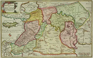
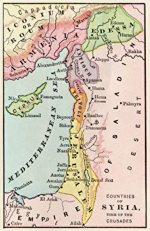
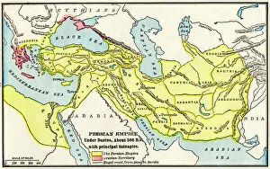
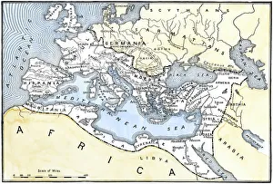
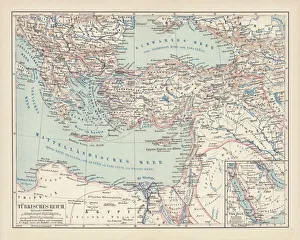
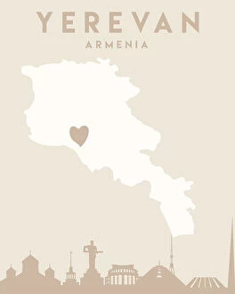
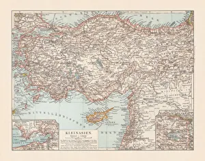
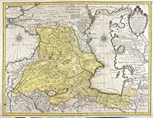
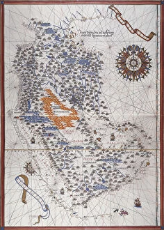
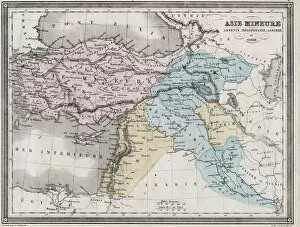
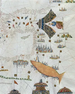
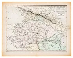
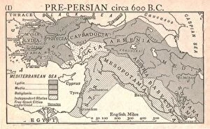
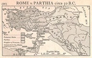
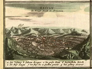
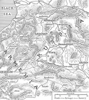
Maps of Armenia Europe are important tools for understanding the geography of the region. Armenia is a landlocked country located in the Caucasus region between Europe and Asia, and is bordered by Turkey, Georgia, Azerbaijan, and Iran. Maps of Armenia provide detailed information about its physical features such as rivers, lakes, mountains, valleys and other topographical features. They also show major cities and towns as well as roads and railroads that connect them to each other. Maps of Armenia can also be used to identify natural resources such as oil fields or mineral deposits. Additionally, they provide information about political boundaries between countries in the region which can be useful for travelers who need to know where they are allowed to go when crossing borders.
+

Our beautiful pictures are available as Framed Prints, Photos, Wall Art and Photo Gifts

Media Storehouse offers a collection of Maps of Armenia Europe, which includes high-quality wall art and framed prints. Our collection features various maps that showcase the geography, topography, and political boundaries of Armenia in Europe. These maps are created by skilled cartographers who have accurately depicted the country's landscape and its surrounding regions. The Maps of Armenia Europe collection is an excellent resource for those interested in exploring Armenian history or studying its geography. It provides a visual representation of how the country has evolved over time and helps to understand its place within the European continent. The wall art and framed prints offered by Media Storehouse are made using premium materials to ensure longevity and durability. They can be used to decorate homes, offices, or educational institutions with beautiful artwork that also serves as informative tools. The Maps of Armenia Europe collection from Media Storehouse is an ideal choice for anyone seeking high-quality wall art or framed prints depicting accurate representations of Armenian geography and history.
+

What are Maps of Armenia Europe art prints?

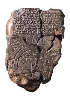
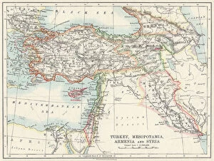
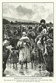
Maps of Armenia Europe art prints are high-quality reproductions of maps that depict the geographical features and political boundaries of Armenia, a country located in the South Caucasus region of Eurasia. These art prints showcase various historical periods and styles, ranging from antique maps dating back to the 17th century to modern-day cartography. These art prints offer a unique way to explore and appreciate Armenian history, culture, and geography. They can be used as educational resources for students or as decorative pieces for homes or offices. Maps of Armenia Europe art prints come in different sizes and formats, including framed or unframed options. Whether you're an avid collector of maps or simply interested in learning more about this fascinating country's past and present, these art prints are an excellent choice. With their intricate details and vibrant colors, they capture the beauty and complexity of Armenia's landscapes while providing valuable insights into its rich cultural heritage.
+

What Maps of Armenia Europe art prints can I buy from Media Storehouse?

We offer a wide range of Maps of Armenia Europe art prints that you can buy. These maps are available in different sizes, styles, and formats to suit your preferences. You can choose from vintage maps that showcase the historical evolution of Armenia or contemporary ones that highlight its modern infrastructure and landmarks. Some popular options include detailed topographical maps that display the country's mountain ranges, rivers, and valleys or political maps that show its administrative divisions and neighboring countries. There are also artistic renditions featuring colorful illustrations or calligraphy designs inspired by Armenian culture and heritage. Whether you're an avid traveler who wants to explore Armenia's geography or a history buff interested in tracing its roots, we have something for everyone. With high-quality printing techniques and premium materials used for each print, you can be assured of getting a stunning piece of artwork that will last for years to come.
+

How do I buy Maps of Armenia Europe art prints?

To buy Maps of Armenia Europe art prints from Media Storehouse, you can browse our extensive collection of maps and select the one that appeals to you. Once you have found your desired print, simply add it to your cart and proceed to checkout. You will be prompted to enter your shipping and payment information, after which you can complete the purchase. We offer a variety of sizes for their prints, so make sure to choose the size that best fits your needs. We also offer framing options if you want a ready-to-hang piece of art. If you have any questions or concerns about purchasing from Media Storehouse, they have a customer service team available to assist you. Buying Maps of Armenia Europe art prints from Media Storehouse is a straightforward process that allows you to easily bring beautiful artwork into your home or office space.
+

How much do Maps of Armenia Europe art prints cost?

Maps of Armenia Europe art prints are available for purchase at Media Storehouse. The cost of these prints varies depending on the size, material, and framing options selected by the buyer. You can choose from a range of sizes to suit their needs and budget. Additionally, there are various materials available such as canvas or paper that affect the price. The prices for Maps of Armenia Europe art prints at Media Storehouse are competitive with other online retailers offering similar products. However, it is important to note that prices may vary depending on where you live in the world due to currency exchange rates. If you're looking for high-quality Maps of Armenia Europe art prints at affordable prices then Media Storehouse is an excellent option to consider. Their selection is vast and varied so you're sure to find something that suits your taste and budget.
+

How will my Maps of Armenia Europe art prints be delivered to me?

Your Maps of Armenia Europe art prints will be delivered to you via a reliable and secure shipping service. The prints are carefully packaged to ensure that they arrive in perfect condition, ready for framing or display. Depending on your location, the delivery may take a few days or longer, but rest assured that we work with trusted carriers who prioritize safe and timely delivery. We understand how important it is for our customers to receive their orders promptly and without any damages. That's why we take great care in packaging your order so that it arrives at your doorstep in pristine condition. Whether you're ordering one print or several, we treat each item with the same level of attention and care. Once your order has been shipped, you will receive a tracking number so that you can monitor its progress until it reaches you. We strive to make the entire process as seamless as possible so that all you have to do is sit back and wait for your beautiful Maps of Armenia Europe art prints to arrive.