Fine Art Print > Arts > Artists > H > Franz Hogenberg
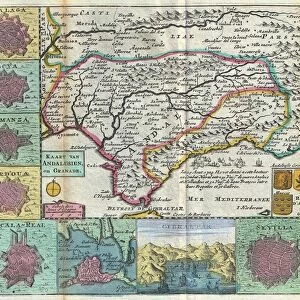
Fine Art Print : Spain. Castile and Leon. Burgos. Map, 1576 at Civitates


![]()
Fine Art Prints from Mary Evans Picture Library
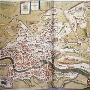
Spain. Castile and Leon. Burgos. Map, 1576 at Civitates
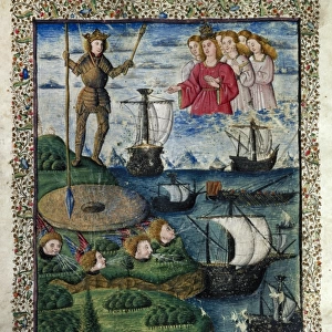
Spain. Castile and Leon. Burgos. Map, 1576 at Civitates Orbis Terrarum by Georg Braun (1541-1622) and Franz Hogenberg (1536-1590). Salamanca University Library
Mary Evans Picture Library makes available wonderful images created for people to enjoy over the centuries
Media ID 14406726
© Thaliastock / Mary Evans
1576 Burgos Cartography Castile Castilia Castilian Cattle Civitates Crop Donkey Farmer Flock Hogenberg Leon Livestock Orbis Raising Terrarum
A2 (42x59cm) Fine Art Print
Discover the rich history and culture of Spain's Castile and Leon region with our exquisite Fine Art Print of the ancient map of Burgos, dating back to 1576. This captivating piece, taken from the renowned Civitates Orbis Terrarum collection, is a stunning representation of the geographical knowledge of the time, meticulously crafted by Georg Braun and Franz Hogenberg. Bring a piece of history into your home or office with this beautifully detailed and intriguing work of art, now available through Media Storehouse's extensive range of rights-managed prints from Mary Evans Prints Online.
Our Fine Art Prints are printed on 100% acid free, PH neutral paper with archival properties. This printing method is used by museums and art collections to exhibit photographs and art reproductions. Hahnemühle certified studio for digital fine art printing. Printed on 308gsm Photo Rag Paper.
Our fine art prints are high-quality prints made using a paper called Photo Rag. This 100% cotton rag fibre paper is known for its exceptional image sharpness, rich colors, and high level of detail, making it a popular choice for professional photographers and artists. Photo rag paper is our clear recommendation for a fine art paper print. If you can afford to spend more on a higher quality paper, then Photo Rag is our clear recommendation for a fine art paper print.
Estimated Image Size (if not cropped) is 59.4cm x 23.4cm (23.4" x 9.2")
Estimated Product Size is 59.4cm x 42cm (23.4" x 16.5")
These are individually made so all sizes are approximate
Artwork printed orientated as per the preview above, with landscape (horizontal) orientation to match the source image.
FEATURES IN THESE COLLECTIONS
> Animals
> Farm
> Cattle
> Related Images
> Animals
> Farm
> Donkeys
> Related Images
> Animals
> Mammals
> Bovidae
> Cattle
> Arts
> Artists
> H
> Franz Hogenberg
> Arts
> Landscape paintings
> Landscape art
> Landscape paintings
> Europe
> France
> Canton
> Landes
> Europe
> Spain
> Related Images
> Maps and Charts
> Related Images
EDITORS COMMENTS
This map print, titled "Burgos" from the atlas "Civitates Orbis Terrarum," was created by the renowned cartographers Georg Braun and Franz Hogenberg in the year 1576. The map is part of the extensive collection housed in the historic Salamanca University Library in Spain. The map provides an intriguing glimpse into the geography and topography of Castile and Leon, specifically the province of Burgos during the 16th century. The intricate detail and vibrant colors of the map bring the landscape to life, depicting a diverse range of landscapes, from rolling hills and lush fields to sprawling cities and bustling markets. The map features several notable landmarks, including the city of Burgos, situated at the heart of the region. The city is shown with its impressive cathedral, surrounded by defensive walls and fortifications. The map also highlights several other towns and villages, connected by winding roads and rivers. The rural areas of the map are filled with images of farmers and herdsmen tending to their livestock, with cattle and sheep grazing in the fields. The use of color adds depth and texture to the map, with different crops depicted in various shades of green and brown. This map is a testament to the remarkable cartographic skills of Braun and Hogenberg, who meticulously documented the world as it was known at the time. It offers a fascinating window into the history and culture of Castile and Leon during the late 16th century, providing valuable insights into the daily life and economic activities of the region.
MADE IN THE UK
Safe Shipping with 30 Day Money Back Guarantee
FREE PERSONALISATION*
We are proud to offer a range of customisation features including Personalised Captions, Color Filters and Picture Zoom Tools
SECURE PAYMENTS
We happily accept a wide range of payment options so you can pay for the things you need in the way that is most convenient for you
* Options may vary by product and licensing agreement. Zoomed Pictures can be adjusted in the Basket.