Fraud Blocker Skip to main content

Home > Arts > Artists > P > Portuguese School

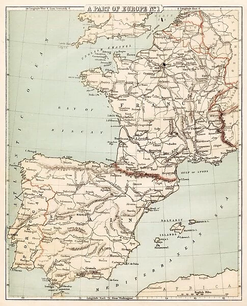
Map of Spain and France 1869

Map of Spain and France 1869
Sold 2
In Stock
We accept all major credit cards

Fine Art Storehouse Photo Prints and Wall Art

Map of Spain and France 1869

Cornells Grammars-School Geography - S.S. Cornell - New York D. Appleton and Company 1869. Unleash your creativity and transform your space into a visual masterpiece. © Roberto A Sanchez

THEPALMER

Media ID 13668859

62990 Earth Globe Man Made Object Globe Navigational Equipment Portugal Obsolete Retro Styled

FEATURES IN THESE COLLECTIONS

> Arts > Artists > P > Portuguese School

> Arts > Artists > S > Spanish School

> Europe > France > Maps

> Europe > Portugal > Maps

> Europe > Portugal > Posters

> Europe > Portugal > Related Images

> Europe > Spain > Maps

> Europe > Spain > Posters

> Fine Art Storehouse > The Magical World of Illustration > Palmer Illustrated Collection

> Fine Art Storehouse > Map > Historical Maps

> Fine Art Storehouse > Map

> Maps and Charts > France

> Maps and Charts > Portugal

SECURE PAYMENTS
We happily accept a wide range of payment options so you can pay for the things you need in the way that is most convenient for you

MADE IN THE UK
Safe Shipping with 30 Day Money Back Guarantee

FREE PERSONALISATION
We are proud to offer a range of customisation including Cropping, Captions, and Filters. Zoom Cropping can be adjusted in the Basket.


EDITORS COMMENTS

This print showcases a vintage map of Spain and France from the year 1869. The intricate details and retro styling of this antique piece take us back in time to an era when cartography was meticulously engraved by hand. This particular image is sourced from "Cornells Grammars-School Geography" a renowned publication by S. S. Cornell, published in New York by D. Appleton and Company. The map itself offers a fascinating glimpse into the past, depicting the physical geography of Spain, Portugal, and France during that period. Its old-world charm evokes feelings of nostalgia as we observe the delicate engravings that bring these countries to life on paper. As we examine this engraving closely, we can appreciate how it represents not only an artistic creation but also a valuable navigational tool used at the time. The globe man-made object featured within adds another layer of intrigue to this composition. "The Map of Spain and France 1869" is more than just an obsolete relic; it serves as a testament to human curiosity about our world's landscapes throughout history. With its vertical orientation and detailed illustration, this print invites us to explore Europe's rich tapestry through both geographical knowledge and artistic appreciation. THEPALMER has skillfully captured this timeless piece with precision, allowing viewers to immerse themselves in its historical significance while admiring its aesthetic beauty.


Framed Prints

Introducing the exquisite "Map of Spain and France 1869" from our Media Storehouse Framed Prints collection. This beautiful vintage map, hailing from the prestigious S.S. Cornell - New York D. Appleton and Company publication, transports you back in time to an era of exploration and discovery. The intricate detailing of the geographical features, political boundaries, and topographical elements of Spain and France in 1869 are showcased in this stunning piece. The rich history of cartography is brought to life with every carefully crafted line and color. Frame this captivating piece in your home or office to add a unique touch of historical charm and elegance to your space. The Media Storehouse Framed Prints are not only a beautiful addition to your decor but also a fascinating glimpse into the past. Embrace the timeless allure of this map from THEPALMER's Fine Art Storehouse collection.


Photo Prints

Introducing the captivating "Map of Spain and France 1869" by THEPALMER from our Media Storehouse Fine Art Prints collection. This exquisite vintage map transports you back in time to an era of exploration and discovery. Originally published in S.S. Cornell's Cornell's Grammars-School Geography by D. Appleton and Company in New York in 1869, this map offers a fascinating glimpse into the geography of Spain and France during that period. The intricate details and beautiful cartography make this a must-have for history enthusiasts, geography buffs, and art collectors alike. Bring a piece of the past into your home or office with this stunning fine art print from Media Storehouse.


Poster Prints

Introducing the captivating "Map of Spain and France 1869" by THEPALMER from our Media Storehouse Poster Prints collection. This exquisite piece is a reproduction of a map published in S.S. Cornell's Cornell's Grammars-School Geography book by D. Appleton and Company in 1869. Travel back in time and explore the historical geography of Europe with this detailed and intricately designed map. The rich colors and high-quality print bring the map to life, making it a perfect addition to any classroom, office, or home decor. Immerse yourself in the history of Europe and add a touch of vintage charm to your space with this stunning poster print.


Jigsaw Puzzles

Discover the rich history and cultural connections between Spain and France with our stunning jigsaw puzzle from Media Storehouse. This captivating puzzle features the intricately detailed "Map of Spain and France 1869" by THEPALMER, originally published in Cornell's Grammars-School Geography by S.S. Cornell, New York D. Appleton and Company in 1869. Immerse yourself in the intricacies of this vintage map, bringing the classic cartography of yesteryears into your modern home. Piecing together this puzzle is not just a fun and engaging activity, but a journey through time, showcasing the geographical changes and historical context of Europe in the late 19th century. Perfect for puzzle enthusiasts, history buffs, or anyone looking for a challenging and rewarding hobby, our Media Storehouse jigsaw puzzles offer a unique blend of education, entertainment, and relaxation. Enjoy the satisfaction of completing a beautiful and intricate puzzle, while expanding your knowledge and appreciation for the world around us.

diamond
Made With High Grade Materials
thumb_up
Professional Quality Finish
package_2
Carefully Packed To Aid Safe Arrival

You May Also Like


Broxi Bear: The Exuberant Mascot of Rangers Football ClubBroxi Bear: The Exuberant Mascot of Rangers Football Club
Add to Basket
Title-page of Thomas Paines pamphlet Common Sense, which urged Americans to declare their independence from Great Britain. It reputedly sold 120, 000 copies in the three months following its publication at Philadelphia on 10 January 1776Title-page of Thomas Paines pamphlet Common Sense, which urged Americans to declare their independence from Great Britain. It reputedly sold 120, 000 copies in the three months following its publication at Philadelphia on 10 January 1776
Add to Basket
Ayr, BR poster, 1948-1965Ayr, BR poster, 1948-1965
Add to Basket
Shire HorseShire Horse
Add to Basket
Joe Marler - England rugby playerJoe Marler - England rugby player
Add to Basket
Thierry Henry (Arsenal). Liverpool 1: 0 Arsenal. FA PremiershipThierry Henry (Arsenal). Liverpool 1: 0 Arsenal. FA Premiership
Add to Basket
Andre Pasdoc PhotoAndre Pasdoc Photo
Add to Basket
Pork Pie Shop 1960SPork Pie Shop 1960S
Add to Basket
Vocal Cornet (Wurlitzer) 1Vocal Cornet (Wurlitzer) 1
Add to Basket
Pearly King & Queen 1920Pearly King & Queen 1920
Add to Basket
Trinity / Cambridge / 1907Trinity / Cambridge / 1907
Add to Basket
Injustice Nawab / BengalInjustice Nawab / Bengal
Add to Basket

Gallery Wall Inspiration

Map of Ireland 1897
Morel mushroom 1891
Poison plants lithograph 1895
Map of the world 1800
Brain anatomy engraving 1895
Human Heart Anatomy 1888
Alice and the Jabberwocky Knight engraving 1899
Greek Urns and Amphoras Lithograph 1897
Map of Venice 1897
Scotland map 1875
The Mad Hatter Tea Party - Alice in Wonderland 1897
The Mouth of Hell of engraving
Dipper bird engraving 1896
Map of Maine USA 1883
Map of Texas 1867
Map of the world 1869
Map of Australia and New Zealand 1856
France Spain Portugal map 1856
Map of Panama 1864
Prague map 1896
India map 1881
White bryony poison plant engraving 1857
England and wales map 1895
Map of Spain and France 1869
Old map of California 1855
Charon the ferryman engraving
Map of Berlin 1895

Discover Our Collections


MapMap
View Collection
Palmer Illustrated CollectionPalmer Illustrated Collection
View Collection
Portugal Related ImagesPortugal Related Images
View Collection
MapsMaps
View Collection
MapsMaps
View Collection
MapsMaps
View Collection
Portuguese SchoolPortuguese School
View Collection
Spanish SchoolSpanish School
View Collection
FranceFrance
View Collection
PortugalPortugal
View Collection
PostersPosters
View Collection
PostersPosters
View Collection
Historical MapsHistorical Maps
View Collection


© Copyright Media Storehouse, All Rights Reserved 2003 - 2024
Facebook     Pinterest     Card Payments     Reviews IO