Fine Art Print > Europe > Italy > Sicily > Messina
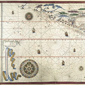
Fine Art Print : Portolan chart, 1582. Map of the central part


![]()
Fine Art Prints from Mary Evans Picture Library
Portolan chart, 1582. Map of the central part
Portolan chart, 1582. Map of the central part of the Mediterranean sea. Printed in Messina. Renaissance art. Miniature Painting
Mary Evans Picture Library makes available wonderful images created for people to enjoy over the centuries
Media ID 8282571
© Mary Evans Picture Library 2015 - https://copyrighthub.org/s0/hub1/creation/maryevans/MaryEvansPictureID/10681992
Chart Cities Compass Geographic Geographical Illuminated Italia Italians Manuscript Manuscripts Mediterranean Messina Miniatures Peninsula Portolan Renaissance
A2 (42x59cm) Fine Art Print
Discover the captivating allure of the past with our exquisite selection of Fine Art Prints from Media Storehouse. This particular print showcases a stunning Portolan chart from 1582, depicting the central part of the Mediterranean Sea. Originally created in Messina during the Renaissance period, this intricately detailed miniature painting is a testament to the artistic mastery of the time. Each print is meticulously reproduced to preserve the authenticity and vibrancy of the original work, making it an exceptional addition to any home or office. Immerse yourself in history and beauty with our Fine Art Prints.
Our Fine Art Prints are printed on 100% acid free, PH neutral paper with archival properties. This printing method is used by museums and art collections to exhibit photographs and art reproductions. Hahnemühle certified studio for digital fine art printing. Printed on 308gsm Photo Rag Paper.
Our fine art prints are high-quality prints made using a paper called Photo Rag. This 100% cotton rag fibre paper is known for its exceptional image sharpness, rich colors, and high level of detail, making it a popular choice for professional photographers and artists. Photo rag paper is our clear recommendation for a fine art paper print. If you can afford to spend more on a higher quality paper, then Photo Rag is our clear recommendation for a fine art paper print.
Estimated Image Size (if not cropped) is 40.9cm x 59.4cm (16.1" x 23.4")
Estimated Product Size is 42cm x 59.4cm (16.5" x 23.4")
These are individually made so all sizes are approximate
Artwork printed orientated as per the preview above, with portrait (vertical) orientation to match the source image.
FEATURES IN THESE COLLECTIONS
> Arts
> Art Movements
> Renaissance Art
> Europe
> Italy
> Related Images
> Europe
> Italy
> Sicily
> Messina
> Historic
> Renaissance art
> Italian Renaissance art
EDITORS COMMENTS
This exquisite print, dating back to 1582, showcases a captivating Portolan chart, focusing on the central part of the Mediterranean Sea. The map, produced in Messina, Italy, is a prime example of the Renaissance period's artistic and geographical advancements. The intricately detailed chart illustrates the Italian peninsula, various cities, and islands scattered throughout the Mediterranean. The urban landscapes are depicted with a sense of realism, showcasing the architectural beauty and vibrancy of each city. The geographical features are rendered with precision, making this chart an essential tool for mariners of the time. The map is adorned with an illuminated compass rose, adding an artistic touch to the functional chart. The use of miniature painting techniques adds depth and dimension to the map, making it a work of art in its own right. The rich colors and fine lines create a visual feast for the eyes, transporting us back to the bustling ports and vibrant cities of the Mediterranean during the Renaissance period. Despite its age, this Portolan chart remains an impressive testament to the Italians' mastery of cartography and their commitment to the pursuit of knowledge during the Renaissance era. The intricate details and artistic elements make it a valuable addition to any collection of historical maps or works of art.
MADE IN THE UK
Safe Shipping with 30 Day Money Back Guarantee
FREE PERSONALISATION*
We are proud to offer a range of customisation features including Personalised Captions, Color Filters and Picture Zoom Tools
SECURE PAYMENTS
We happily accept a wide range of payment options so you can pay for the things you need in the way that is most convenient for you
* Options may vary by product and licensing agreement. Zoomed Pictures can be adjusted in the Basket.