Fine Art Print > Aerial Photography > Related Images
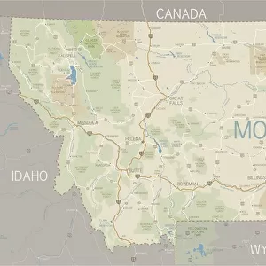
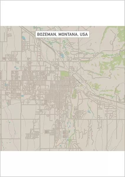
Fine Art Print : Bozeman Montana US City Street Map


![]()
Fine Art Prints from Fine Art Storehouse
Bozeman Montana US City Street Map
Vector Illustration of a City Street Map of Bozeman, Montana, USA. Scale 1:60, 000.
All source data is in the public domain.
U.S. Geological Survey, US Topo
Used Layers:
USGS The National Map: National Hydrography Dataset (NHD)
USGS The National Map: National Transportation Dataset (NTD)
Unleash your creativity and transform your space into a visual masterpiece!
Frank Ramspott
Media ID 15054905
© Frank Ramspott, all rights reserved
Aerial View City Map Computer Graphic Directly Above Downtown District Gray Montana Road Map Text Bozeman Digitally Generated Image Green Color White Color
A2 (42x59cm) Fine Art Print
Discover the charm of Bozeman, Montana with our stunning Fine Art Print by Frank Ramspott. This intricately detailed vector illustration of the city street map showcases the unique character and layout of this vibrant US city. With a scale of 1:60,000 and all source data in the public domain, this print is not only a beautiful addition to any home or office, but also a valuable resource for those with a connection to Bozeman or an appreciation for fine cartography. Bring a piece of Montana's history and culture into your space with this exquisite Fine Art Print from Media Storehouse.
Our Fine Art Prints are printed on 100% acid free, PH neutral paper with archival properties. This printing method is used by museums and art collections to exhibit photographs and art reproductions. Hahnemühle certified studio for digital fine art printing. Printed on 308gsm Photo Rag Paper.
Our fine art prints are high-quality prints made using a paper called Photo Rag. This 100% cotton rag fibre paper is known for its exceptional image sharpness, rich colors, and high level of detail, making it a popular choice for professional photographers and artists. Photo rag paper is our clear recommendation for a fine art paper print. If you can afford to spend more on a higher quality paper, then Photo Rag is our clear recommendation for a fine art paper print.
Estimated Image Size (if not cropped) is 42cm x 42cm (16.5" x 16.5")
Estimated Product Size is 42cm x 59.4cm (16.5" x 23.4")
These are individually made so all sizes are approximate
Artwork printed orientated as per the preview above, with landscape (horizontal) or portrait (vertical) orientation to match the source image.
FEATURES IN THESE COLLECTIONS
> Aerial Photography
> Related Images
> Animals
> Insects
> Hemiptera
> Green Scale
> Arts
> Contemporary art
> Digital artwork
> Street art
> Arts
> Landscape paintings
> Waterfall and river artworks
> River artworks
> Arts
> Portraits
> Pop art gallery
> Street art portraits
> Arts
> Street art graffiti
> Digital art
> Digital paintings
> Arts
> Street art graffiti
> Digital art
> Vector illustrations
> Maps and Charts
> Geological Map
> Maps and Charts
> Related Images
> North America
> United States of America
> Lakes
> Related Images
> Fine Art Storehouse
> Map
> Street Maps
> Fine Art Storehouse
> Map
> USA Maps
EDITORS COMMENTS
This print showcases a meticulously crafted vector illustration of the charming city street map of Bozeman, Montana, USA. With a scale of 1:60,000, every intricate detail is brought to life in this visually stunning artwork. The source data used for this creation is from the public domain and includes USGS The National Map's National Hydrography Dataset (NHD) and National Transportation Dataset (NTD). The image captures the essence of Bozeman's downtown district with its vibrant streets, meandering river, and picturesque lake. Its expertly designed cartography seamlessly blends various shades of gray, blue, white, and green to create a visually striking composition that highlights both the physical geography and urban layout of the city. Rendered as a digitally generated image from an aerial perspective directly above Bozeman, this artwork offers viewers an immersive experience into the heart of this thriving town. Notably absent are any human figures; instead, attention is solely focused on appreciating the beauty and intricacy of this masterfully created map. Created by talented artist Frank Ramspott exclusively for Fine Art Storehouse's collection, this unique piece combines artistry with functionality. Whether you are a resident or visitor to Bozeman or simply appreciate exceptional cartographic design, this print promises to be an eye-catching addition to any space.
MADE IN THE UK
Safe Shipping with 30 Day Money Back Guarantee
FREE PERSONALISATION*
We are proud to offer a range of customisation features including Personalised Captions, Color Filters and Picture Zoom Tools
SECURE PAYMENTS
We happily accept a wide range of payment options so you can pay for the things you need in the way that is most convenient for you
* Options may vary by product and licensing agreement. Zoomed Pictures can be adjusted in the Basket.