Fine Art Print > Fine Art Storehouse > Map
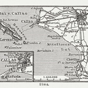
Fine Art Print : Antique map of Peru and Ecuador with plans for Lima


![]()
Fine Art Prints from Fine Art Storehouse
Antique map of Peru and Ecuador with plans for Lima
Unleash your creativity and transform your space into a visual masterpiece!
Hemera Technologies
Media ID 13609431
© Getty Images
18th Century 18th Century Style Columns Culture Custom Ecuador Equator Geography Natural Column Peru Plan Scene Scenes South America Text Vignette Vignettes Words Chatelain Lima Lima Peru Plans
A2 (42x59cm) Fine Art Print
Step back in time with our exquisite Antique Map of Peru and Ecuador with Plans for Lima from the Media Storehouse Fine Art Prints collection. This captivating piece, produced by Hemera Technologies, showcases intricate details of the region's historical geography and urban planning. The vintage map design transports you to a bygone era, making it a stunning addition to any home or office space. Bring history to life with this beautiful fine art print.
Our Fine Art Prints are printed on 100% acid free, PH neutral paper with archival properties. This printing method is used by museums and art collections to exhibit photographs and art reproductions. Hahnemühle certified studio for digital fine art printing. Printed on 308gsm Photo Rag Paper.
Our fine art prints are high-quality prints made using a paper called Photo Rag. This 100% cotton rag fibre paper is known for its exceptional image sharpness, rich colors, and high level of detail, making it a popular choice for professional photographers and artists. Photo rag paper is our clear recommendation for a fine art paper print. If you can afford to spend more on a higher quality paper, then Photo Rag is our clear recommendation for a fine art paper print.
Estimated Image Size (if not cropped) is 42cm x 55.1cm (16.5" x 21.7")
Estimated Product Size is 42cm x 59.4cm (16.5" x 23.4")
These are individually made so all sizes are approximate
Artwork printed orientated as per the preview above, with portrait (vertical) orientation to match the source image.
FEATURES IN THESE COLLECTIONS
> Fine Art Storehouse
> Map
> Historical Maps
EDITORS COMMENTS
This 18th-century print showcases an antique map of Peru and Ecuador, adorned with intricate plans for the vibrant city of Lima. A true treasure from the past, this archival piece takes us on a journey through time, revealing the rich cartography and historical significance of South America. The expertly engraved details bring to life the cultural heritage of these nations, as vignettes and scenes gracefully intertwine with columns of text. The vintage color image adds a touch of nostalgia, immersing viewers in a bygone era where exploration and discovery were paramount. As we delve into this remarkable artwork, our eyes are drawn to Lima's grandeur depicted in its meticulously crafted plans. The bustling streets come alive with custom scenes that capture the essence of daily life during that period. From historic landmarks to natural columns dotting the landscape, every element tells a story about Peru's fascinating history and physical geography. With its vertical composition and exquisite craftsmanship, this antique map invites us to appreciate not only its aesthetic beauty but also its educational value. It serves as a testament to human curiosity and our relentless pursuit of knowledge throughout centuries. Hemera Technologies has preserved this invaluable piece from their collection at Fine Art Storehouse so that we may continue to marvel at its splendor today.
MADE IN THE UK
Safe Shipping with 30 Day Money Back Guarantee
FREE PERSONALISATION*
We are proud to offer a range of customisation features including Personalised Captions, Color Filters and Picture Zoom Tools
SECURE PAYMENTS
We happily accept a wide range of payment options so you can pay for the things you need in the way that is most convenient for you
* Options may vary by product and licensing agreement. Zoomed Pictures can be adjusted in the Basket.