Home > Europe > United Kingdom > England > Yorkshire > Richmond
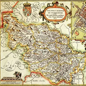
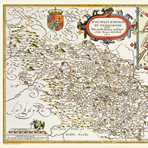
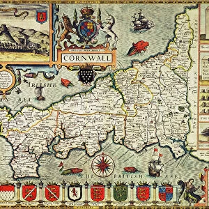
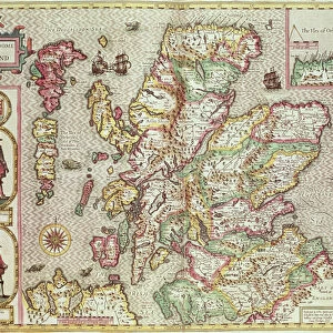
The West Ridinge of Yorkeshyre, engraved by Jodocus Hondius (1563-1612) from John
 from John")
![]()
Wall Art and Photo Gifts from Fine Art Finder
The West Ridinge of Yorkeshyre, engraved by Jodocus Hondius (1563-1612) from John
XCF306017 The West Ridinge of Yorkeshyre, engraved by Jodocus Hondius (1563-1612) from John Speeds Theatre of the Empire of Great Britain, 1611-12 (hand-coloured copper engraving) by Speed, John (1552-1629) (after); Private Collection; English, out of copyright
Media ID 12840926
© www.bridgemanart.com
Borders Boundaries Cartography Cartouche Compass County Crest Divisions Geographical Hull Mapping Richmond Stuart York Yorkshire Cherubs Yorke
FEATURES IN THESE COLLECTIONS
> Arts
> Artists
> H
> Jodocus Hondius
> Arts
> Artists
> S
> John Speed
> Europe
> United Kingdom
> England
> Maps
> Europe
> United Kingdom
> England
> York
> Europe
> United Kingdom
> England
> Yorkshire
> Hull
> Europe
> United Kingdom
> England
> Yorkshire
> Richmond
> Fine Art Finder
> Artists
> John (after) Speed
> Fine Art Finder
> Maps (celestial & Terrestrial)
EDITORS COMMENTS
This print showcases "The West Ridinge of Yorkeshyre" an exquisite engraved map created by Jodocus Hondius in the late 16th century. The intricate details and stunning craftsmanship are evident in this hand-coloured copper engraving, which is a part of John Speed's renowned Theatre of the Empire of Great Britain collection. The map depicts the historic region of Yorkshire, England, with its various towns and cities beautifully illustrated. From Hull to Richmond, each location is meticulously portrayed along with their distinctive coat of arms. The compass rose adds a touch of elegance while cherubs gracefully adorn the corners, adding a whimsical charm to the overall composition. With its elaborate cartouche and precise mapping techniques, this artwork offers us a glimpse into the rich history and geography that defined 17th-century England. It serves as both a historical document and a testament to the skillful artistry employed during that era. As we explore this remarkable piece further, we can appreciate how it captures not only geographical boundaries but also cultural divisions within Yorkshire during the Stuart period. This print invites us to delve into English heritage and discover more about our past through cartography. Displayed here courtesy of www. bridgemanart. com, this print allows us to marvel at an extraordinary work that combines artistry with historical significance.
MADE IN THE UK
Safe Shipping with 30 Day Money Back Guarantee
FREE PERSONALISATION*
We are proud to offer a range of customisation features including Personalised Captions, Color Filters and Picture Zoom Tools
SECURE PAYMENTS
We happily accept a wide range of payment options so you can pay for the things you need in the way that is most convenient for you
* Options may vary by product and licensing agreement. Zoomed Pictures can be adjusted in the Basket.