Home > Historic > Battles > Related Images
Map of the United States of America, British provinces, Mexico, West Indies and Central America

![]()
Wall Art and Photo Gifts from Fine Art Finder
Map of the United States of America, British provinces, Mexico, West Indies and Central America
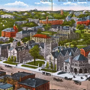
XOS1765719 Map of the United States of America, British provinces, Mexico, West Indies and Central America, 1850 (hand coloured print) by American School, (19th century); 87x107 cm; New York Public Library, USA; (add.info.: Inset maps of the Atlantic Ocean showing the American & European ports and the routes of the ocean steamers and another of the Isthmus of Panama and pictures of Vallery of the Connecticut, Washington Capitol, Mexico Cathedral, Willammette Falls & Astoria in Oregon, Saratoga Lake in New York & various monuments. ); American, out of copyright
Media ID 12742625
© www.bridgemanimages.com
Atlantic Ocean Atlas Baltimore British Colony Bunker Hill Caribbean Caribbean Sea Central America Colonial America Gulf Of Mexico Hydrography Islands Navigation Panama Sea Chart Washington Pulaski
FEATURES IN THESE COLLECTIONS
> Fine Art Finder
> Schools
> American School
> Historic
> Battles
> Related Images
> North America
> Mexico
> Lakes
> Related Images
> North America
> Mexico
> Related Images
> North America
> Panama
> Lakes
> Related Images
> North America
> Panama
> Related Images
> North America
> Related Images
> North America
> United States of America
> Connecticut
> Related Images
> North America
> United States of America
> Lakes
> Related Images
> North America
> United States of America
> New Mexico
> Related Images
> North America
> United States of America
> New York
> Related Images
EDITORS COMMENTS
This hand-coloured print from the 19th century showcases a detailed and captivating "Map of the United States of America, British provinces, Mexico, West Indies and Central America". Spanning an impressive 87x107 cm, this historical map is housed in the prestigious New York Public Library. The map not only provides a comprehensive view of North and South America but also includes inset maps highlighting the American and European ports as well as the routes taken by ocean steamers. Another intriguing inset focuses on the Isthmus of Panama. Additionally, this print features picturesque images such as the Valley of Connecticut, Washington Capitol, Mexico Cathedral, Willamette Falls & Astoria in Oregon, Saratoga Lake in New York, and various monuments. Cartography enthusiasts will appreciate how this map delves into maritime navigation with its depiction of sea charts and hydrography along coastlines. The Atlantic Ocean takes center stage here with its islands scattered throughout—particularly those found within the Caribbean Sea and Gulf of Mexico. Historically significant locations are also highlighted on this print: from colonial America to British colonies like Port Bunker Hill; from pivotal battles like Pulaski to iconic landmarks such as Baltimore. Overall, this stunning piece offers a glimpse into both past geography and cartographic expertise while providing viewers with an immersive journey through time.
MADE IN THE UK
Safe Shipping with 30 Day Money Back Guarantee
FREE PERSONALISATION*
We are proud to offer a range of customisation features including Personalised Captions, Color Filters and Picture Zoom Tools
SECURE PAYMENTS
We happily accept a wide range of payment options so you can pay for the things you need in the way that is most convenient for you
* Options may vary by product and licensing agreement. Zoomed Pictures can be adjusted in the Basket.