Home > Europe > Albania > Maps
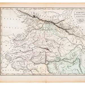
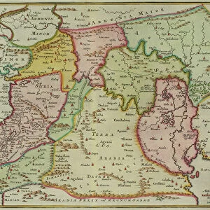
Map of Armenia, Colchis, Iberia and Albania, from The Atlas of Ancient Geography

![]()
Wall Art and Photo Gifts from Fine Art Finder
Map of Armenia, Colchis, Iberia and Albania, from The Atlas of Ancient Geography
KW288096 Map of Armenia, Colchis, Iberia and Albania, from The Atlas of Ancient Geography, by Samuel Butler, published in London, c.1829 (colour litho) by English School, (19th century); Private Collection; Ken Welsh; English, out of copyright
Media ID 12791709
© www.bridgemanimages.com
FEATURES IN THESE COLLECTIONS
> Asia
> Armenia
> Related Images
> Europe
> Albania
> Related Images
> Europe
> Armenia
> Related Images
> Europe
> Russia
> Related Images
> Fine Art Finder
> Schools
> English School
EDITORS COMMENTS
This print showcases a remarkable piece of history - the "Map of Armenia, Colchis, Iberia and Albania" from The Atlas of Ancient Geography. Created by Samuel Butler and published in London around 1829, this exquisite map offers a glimpse into the past with its intricate details and vibrant colors. The map takes us on a journey through time as we explore the ancient lands of Armenia, Colchis, Iberia, and Albania. Each region is meticulously depicted with precision and accuracy, allowing us to visualize the geographical features that shaped these civilizations. From towering mountains to winding rivers, this map highlights the diverse landscapes that once thrived in these territories. It invites us to imagine how people navigated through these lands centuries ago and how they interacted with their surroundings. As we study this masterpiece closely, it becomes evident that cartography is not just about geography; it's an art form that tells stories of cultures long gone. This particular print captures our attention with its rich hues and fine lithographic technique. Whether you are a history enthusiast or simply appreciate beautiful artwork, this print will transport you back in time. It serves as a reminder of the importance of preserving our collective heritage while also celebrating the artistic achievements found within historical maps like this one.
MADE IN THE UK
Safe Shipping with 30 Day Money Back Guarantee
FREE PERSONALISATION*
We are proud to offer a range of customisation features including Personalised Captions, Color Filters and Picture Zoom Tools
SECURE PAYMENTS
We happily accept a wide range of payment options so you can pay for the things you need in the way that is most convenient for you
* Options may vary by product and licensing agreement. Zoomed Pictures can be adjusted in the Basket.