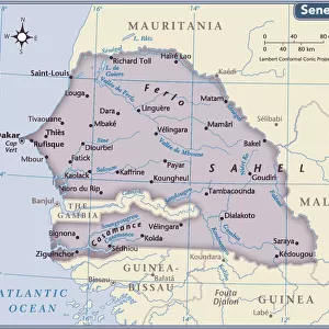
Home > Arts > Portraits > Pop art gallery > Street art portraits
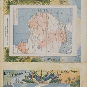
Africa Francaise, Senegal - France and its Colonies. Atlas illustrates one hundred and five maps from the maps of the depot of war, bridges and footwear and the Navy by M. VUILLEMIN. 1876

![]()
Wall Art and Photo Gifts from Fine Art Finder
Africa Francaise, Senegal - France and its Colonies. Atlas illustrates one hundred and five maps from the maps of the depot of war, bridges and footwear and the Navy by M. VUILLEMIN. 1876
XEE4144393 Africa Francaise, Senegal - France and its Colonies. Atlas illustrates one hundred and five maps from the maps of the depot of war, bridges and footwear and the Navy by M. VUILLEMIN. 1876. by Vuillemin, Alexandre (1812-1886); Private Collection; (add.info.: Africa Francaise, Senegal - France and its Colonies. Atlas illustrates one hundred and five maps from the maps of the depot of war, bridges and footwear and the Navy by M. VUILLEMIN. 1876.); Stefano Bianchetti
Media ID 25213552
© Stefano Bianchetti / Bridgeman Images
Alexandre Vuillemin Atlas Book City Map City Plan General Map Geographical Map Senegal Senegalese Street Plan Vuillemin Alexandre 1812 1886 Afica Afric Central Africa
FEATURES IN THESE COLLECTIONS
> Africa
> Related Images
> Africa
> Senegal
> Related Images
> Arts
> Artists
> Related Images
> Arts
> Portraits
> Pop art gallery
> Street art portraits
> Fine Art Finder
> Artists
> Alexandre Vuillemin
> Fine Art Finder
> Artists
> Ludvik Strimpl
> Maps and Charts
> Early Maps
EDITORS COMMENTS
This print showcases a historical atlas titled "Africa Francaise, Senegal - France and its Colonies". Created in 1876 by Alexandre Vuillemin, this atlas features an impressive collection of one hundred and five maps. The maps were sourced from the depot of war, bridges, footwear, and the Navy, providing valuable geographical information about Africa during that time. The image captures the essence of colonialism as it depicts French influence throughout Africa. The vibrant colors used in the engraving bring life to each map, highlighting various regions within Africa. From central Africa to Senegal and beyond, these maps offer a comprehensive view of French territories on the continent. Alexandre Vuillemin's artistic talent shines through his intricate engravings. His attention to detail is evident in every line and contour depicted on these maps. This piece serves not only as a historical record but also as a work of art that reflects the artist's dedication to capturing accurate representations. As we observe this print from Stefano Bianchetti's private collection today, we are reminded of both the beauty and complexity of African geography during this period. It offers us an opportunity to reflect on France's colonial past while appreciating Vuillemin's contribution to cartography and artistry in creating such an exquisite atlas.
MADE IN THE UK
Safe Shipping with 30 Day Money Back Guarantee
FREE PERSONALISATION*
We are proud to offer a range of customisation features including Personalised Captions, Color Filters and Picture Zoom Tools
SECURE PAYMENTS
We happily accept a wide range of payment options so you can pay for the things you need in the way that is most convenient for you
* Options may vary by product and licensing agreement. Zoomed Pictures can be adjusted in the Basket.