Home > Europe > United Kingdom > Scotland > Edinburgh > Edinburgh
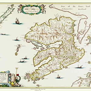
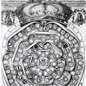
Map of the Kingdom of Great Britain and Ireland, 1610 (hand coloured engraving)
")
![]()
Wall Art and Photo Gifts from Fine Art Finder
Map of the Kingdom of Great Britain and Ireland, 1610 (hand coloured engraving)
XCF275034 Map of the Kingdom of Great Britain and Ireland, 1610 (hand coloured engraving) by Hondius, Jodocus (1567-1611); Private Collection; Dutch, out of copyright
Media ID 12790623
© www.bridgemanart.com
Cartouche Countries Edinburgh Geographical Mapping Stuart
FEATURES IN THESE COLLECTIONS
> Arts
> Artists
> H
> Jodocus Hondius
> Europe
> Republic of Ireland
> Maps
> Europe
> United Kingdom
> England
> Maps
> Europe
> United Kingdom
> Scotland
> Edinburgh
> Edinburgh
> Europe
> United Kingdom
> Scotland
> Edinburgh
> Europe
> United Kingdom
> Scotland
> Lothian
> Edinburgh
> Europe
> United Kingdom
> Scotland
> Maps
> Europe
> United Kingdom
> Scotland
> Posters
> Europe
> United Kingdom
> Scotland
> Related Images
> Fine Art Finder
> Artists
> Jodocus Hondius
EDITORS COMMENTS
This print showcases a beautifully hand-coloured engraving of the "Map of the Kingdom of Great Britain and Ireland, 1610" by Jodocus Hondius. The intricate details and vibrant colors bring this historical map to life, offering a glimpse into the geographical landscape of that era. The map highlights various significant features, including the Irish Sea, London, Edinburgh, and other prominent cities within the British Isles. It also displays a stunning cartouche that adds an artistic touch to this cartographic masterpiece. As we delve into this ancient representation of geography, we are transported back in time to witness how Scotland, England, and Ireland were united under one kingdom during the Stuart era. This visual depiction not only serves as a valuable historical document but also offers insights into political boundaries and regional divisions at that time. With its meticulous craftsmanship and attention to detail, this hand-coloured engraving is truly a remarkable piece of art. Whether you're an enthusiast for mapping or simply intrigued by history's unfolding narratives through visual mediums like cartography, this print is sure to captivate your imagination. Displayed here courtesy of www. bridgemanart. com from their private collection; it allows us to appreciate both the beauty and significance behind such extraordinary works without any commercial intent.
MADE IN THE UK
Safe Shipping with 30 Day Money Back Guarantee
FREE PERSONALISATION*
We are proud to offer a range of customisation features including Personalised Captions, Color Filters and Picture Zoom Tools
SECURE PAYMENTS
We happily accept a wide range of payment options so you can pay for the things you need in the way that is most convenient for you
* Options may vary by product and licensing agreement. Zoomed Pictures can be adjusted in the Basket.