Antique Framed Print > Fine Art Finder > Artists > Jodocus Hondius
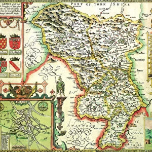
Antique Framed Print : Map of the Kingdom of Great Britain and Ireland, 1610 (hand coloured engraving)
")
")


Please select a smaller print size for this image
![]()
Framed Photos from Fine Art Finder
Map of the Kingdom of Great Britain and Ireland, 1610 (hand coloured engraving)
XCF275034 Map of the Kingdom of Great Britain and Ireland, 1610 (hand coloured engraving) by Hondius, Jodocus (1567-1611); Private Collection; Dutch, out of copyright
Media ID 12790623
© www.bridgemanart.com
Cartouche Countries Edinburgh Geographical Mapping Stuart
14"x12" (36x31cm) Antique Frame
Bevelled wood effect frame, card mounted, 10x8 archival quality photo print. Overall outside dimensions 14x12 inches (36x31cm). Environmentally and ozone friendly, the Polycore® moulding has the look of real wood, is durable and light and easy to hang. Biodegradable and made with non-chlorinated gases (no toxic fumes) it is efficient; producing 100 tons of polystyrene can save 300 tons of trees! Prints are glazed with lightweight, shatterproof, optical clarity acrylic (providing the same general protection from the environment as glass). The back is stapled hardboard with a sawtooth hanger attached. Note: To minimise original artwork cropping, for optimum layout, and to ensure print is secure, the visible print may be marginally smaller
Bevelled Wood Effect Framed and Mounted Prints - Professionally Made and Ready to Hang
Estimated Image Size (if not cropped) is 24.4cm x 18cm (9.6" x 7.1")
Estimated Product Size is 36.3cm x 31.2cm (14.3" x 12.3")
These are individually made so all sizes are approximate
Artwork printed orientated as per the preview above, with landscape (horizontal) orientation to match the source image.
EDITORS COMMENTS
This print showcases a beautifully hand-coloured engraving of the "Map of the Kingdom of Great Britain and Ireland, 1610" by Jodocus Hondius. The intricate details and vibrant colors bring this historical map to life, offering a glimpse into the geographical landscape of that era. The map highlights various significant features, including the Irish Sea, London, Edinburgh, and other prominent cities within the British Isles. It also displays a stunning cartouche that adds an artistic touch to this cartographic masterpiece. As we delve into this ancient representation of geography, we are transported back in time to witness how Scotland, England, and Ireland were united under one kingdom during the Stuart era. This visual depiction not only serves as a valuable historical document but also offers insights into political boundaries and regional divisions at that time. With its meticulous craftsmanship and attention to detail, this hand-coloured engraving is truly a remarkable piece of art. Whether you're an enthusiast for mapping or simply intrigued by history's unfolding narratives through visual mediums like cartography, this print is sure to captivate your imagination. Displayed here courtesy of www. bridgemanart. com from their private collection; it allows us to appreciate both the beauty and significance behind such extraordinary works without any commercial intent.
MADE IN THE UK
Safe Shipping with 30 Day Money Back Guarantee
FREE PERSONALISATION*
We are proud to offer a range of customisation features including Personalised Captions, Color Filters and Picture Zoom Tools
SECURE PAYMENTS
We happily accept a wide range of payment options so you can pay for the things you need in the way that is most convenient for you
* Options may vary by product and licensing agreement. Zoomed Pictures can be adjusted in the Basket.